
Method and system for space and time analysis of urban road traffic states

A technology of road traffic and spatio-temporal analysis, which is applied in traffic flow detection and other directions, can solve the problem of error and lack of spatio-temporal data analysis methods, and achieve the effect of improving rationality and effectiveness

Inactive Publication Date: 2013-04-17
BEIJING JIAOTONG UNIV
View PDF2 Cites 57 Cited by
  • Summary
  • Abstract
  • Description
  • Claims
  • Application Information

AI Technical Summary

Problems solved by technology

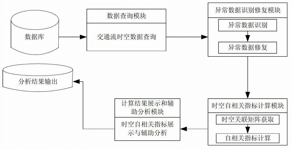
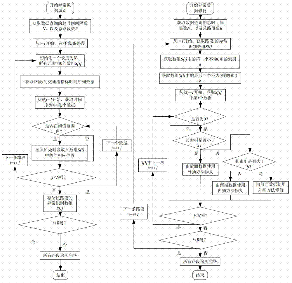
[0008] In order to solve the problems existing in existing researches, such as large errors with actual traffic conditions and lack of spatio-temporal data analysis methods, the technical solution adopted is: a spatio-temporal analysis method and system for urban road traffic status

Method used


Image

  • Method and system for space and time analysis of urban road traffic states
  • Method and system for space and time analysis of urban road traffic states
  • Method and system for space and time analysis of urban road traffic states

Examples


Embodiment Construction

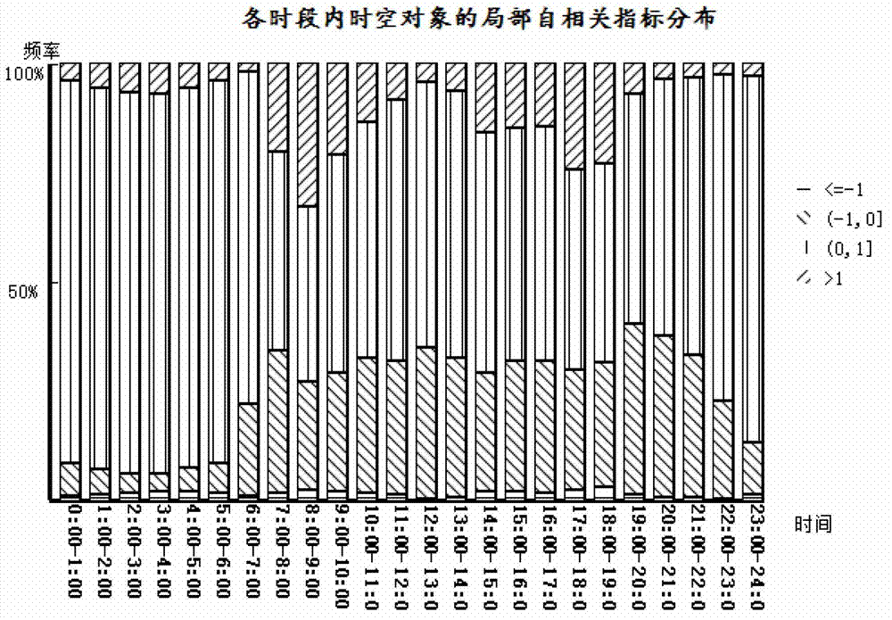
[0047] The present invention is a kind of time-space analysis method of urban road traffic state, this method is based on the theory of space autocorrelation and time autocorrelation, defines the state of a certain road section at a certain moment as a time-space object, then time-space autocorrelation refers to a space-time object The correlation between an attribute value (such as traffic conditions, traffic, etc.) of a road section at a certain moment and the same attribute value of all adjacent spatio-temporal objects. From the perspective of mathematical statistics, an index to measure the spatiotemporal autocorrelation is proposed, and the evolution process of the spatiotemporal state of traffic flow is studied from the perspective of autocorrelation.

[0048] Method of the present invention mainly comprises the following steps:

[0049] Step 1: Read the spatio-temporal data of road network traffic flow required for calculation and analysis from the database. The spatio...


PUM


Abstract

The invention relates to a method and a system for space and time analysis of urban road traffic states. On the basis of a space and time autocorrelation theory, a basic theory of mathematical statistics is applied, and according to the real-time traffic flow data of a road network, the space and time evolution of the traffic states and the generation, development and dissipation process of congestion are analyzed. The distribution features of different road states in space and time are subjected to statistical analysis by the method, the space and time rule of the evolution of the road traffic states of the urban road network is analyzed, the congestion rush hour in time and the bottleneck road in space are identified and judged, and the formulation and implementation of traffic measures are further supported.

Description

technical field [0001] The invention relates to a traffic state analysis system, in particular to a time-space analysis method and system for urban road traffic state. Background technique [0002] Traffic problems are a common challenge faced by big cities. In order to solve the traffic problem, cities at home and abroad have made many efforts, including road network expansion, intersection optimization, intelligent transportation system construction, traffic demand management and other measures. However, the urban road network is a comprehensive and complex large system, and the traffic behavior it undertakes is the evolution process of the interaction between traffic demand and traffic supply. Before formulating and adopting traffic management measures, if the traffic status (smooth and congested) on the traffic network and its temporal and spatial evolution rules cannot be accurately identified, there may be deviations between the measures taken and the actual traffic c...

Claims


Application Information

Patent Timeline
IPC IPC(8): G08G1/01
Inventor 陈绍宽毛保华关伟韦伟刘爽柏赟
Owner BEIJING JIAOTONG UNIV
Learn More