Navigation GEO (geosynchronous orbit) satellite and stationary communication satellite collocating method

A technology of communication satellites and satellites, which is applied in the field of co-location of navigation GEO satellites and stationary communication satellites, to meet the requirements of maintaining cycle between east and west and facilitate engineering operations

Active Publication Date: 2013-05-22
BEIJING INST OF SPACECRAFT SYST ENG
View PDF1 Cites 10 Cited by
  • Summary
  • Abstract
  • Description
  • Claims
  • Application Information

AI Technical Summary

Problems solved by technology

[0005] The technical solution problem of the present invention is: overcome the deficiencies in the prior art, provide a kind of co-location method of navigation GEO satellite and stationary communication satellite, this method is aimed at the mission characteristic of navigation GEO satellite, through eccentricity vector difference and inclination angle vector difference Settings and relative distance settings to solve the problem of safe co-location operation of satellites

Method used


Image

  • Navigation GEO (geosynchronous orbit) satellite and stationary communication satellite collocating method

Examples


Embodiment Construction

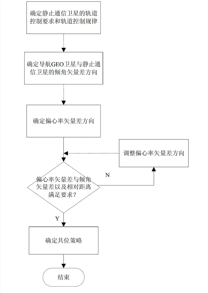
[0022] Such as figure 1 Shown, be the flow chart diagram of the inventive method, concrete steps are as follows:

[0023] The first step is to determine the orbit control requirements and orbit control laws of the geostationary communication satellites to be co-located. strategy, orbit inclination control laws of geostationary communication satellites, etc. By determining the orbit control requirements and orbit control rules of the geostationary communication satellite, the co-location strategy between the navigation GEO satellite and the satellite can be prepared.

[0024] The second step is to determine the direction of the inclination vector difference between the navigation GEO satellite and the stationary communication satellite and the change law of the inclination vector difference according to the satellite's orbit control requirements and orbit control law.

[0025] When determining the direction of the inclination vector difference and the change rule of the incli...


PUM


Abstract

The invention discloses a navigation GEO (geosynchronous orbit) satellite and stationary communication satellite collocating method. The method includes: (1) confirming orbit controlling requirements and orbit controlling rules of a stationary communication satellite; (2) confirming direction and change rules of phasor difference of an inclination angle between the navigation GEO satellite and the stationary communication satellite; (3) confirming the direction of the phasor difference of eccentricity ratio of the navigation GEO satellite compared with the stationary communication satellite; (4) if an included angle between the phasor difference of the inclination angle and the phasor difference of the eccentricity ratio, and the corresponding distance between the navigation GEO satellite and the stationary communication satellite cannot meet set requirements, adjusting the phasor difference of the eccentricity ratio; and (5) confirming a collocating strategy for the navigation GEO satellite and the stationary communication satellite. Aiming at mission feathers of the navigation GEO satellite, the problem of safe collocating operation of the satellites is solved.

Description

technical field [0001] The invention belongs to the field of aerospace vehicle design and relates to a method for co-locating a navigation GEO satellite and a stationary communication satellite. Background technique [0002] Geostationary orbit satellites are widely used in communication, meteorology, navigation and other fields due to their synchronous nature with the earth's rotation. With the utilization of geostationary orbit by various countries, the number of satellites in geostationary orbit is increasing day by day, and its orbital position is becoming increasingly tight. Therefore, the "multi-satellite co-location" method can be used to solve the problem of shortage of orbital position resources. Multi-satellite co-location refers to placing two or more satellites at a fixed point, so that they do not exceed a given orbital interval (fixed point position ± 0.1°) during operation by controlling the orbit. Can not collide and interfere with each other. Among them, p...

Claims


Application Information

Patent Timeline
Patent Type & Authority Applications(China)
IPC IPC(8): B64G1/10
Inventor 高照照杨慧袁莉芳李美红王海红周静雪丹
Owner BEIJING INST OF SPACECRAFT SYST ENG
Why Eureka
Try Eureka