Method and device for simultaneous positioning and map building

A map construction and equipment technology, applied in the directions of maps/plans/charts, 3D modeling, image data processing, etc., can solve the problems of poor map correction ability, time-consuming processing, inaccurate positioning results, etc., to improve the output accuracy , the effect of reducing the computational load

Active Publication Date: 2013-05-29
LENOVO (BEIJING) CO LTD
View PDF7 Cites 32 Cited by
  • Summary
  • Abstract
  • Description
  • Claims
  • Application Information

AI Technical Summary

Problems solved by technology

However, the disadvantages of this algorithm are: 1) the noise of the depth data frequently leads to the mismatch of the closest point; 2) the map correction ability is poor especially for

Method used


Image

  • Method and device for simultaneous positioning and map building
  • Method and device for simultaneous positioning and map building
  • Method and device for simultaneous positioning and map building

Examples


Embodiment Construction

[0022] Various preferred embodiments of the present invention will be described below with reference to the accompanying drawings. The following description with reference to the accompanying drawings is provided to assist understanding of example embodiments of the invention as defined by the claims and their equivalents. It includes various specific details to aid in understanding but they are to be regarded as exemplary only. Accordingly, those of ordinary skill in the art will recognize that various changes and modifications of the embodiments described herein can be made without departing from the scope and spirit of the invention. Also, detailed descriptions of functions and constructions well-known in the art will be omitted to make the description clearer and more concise.

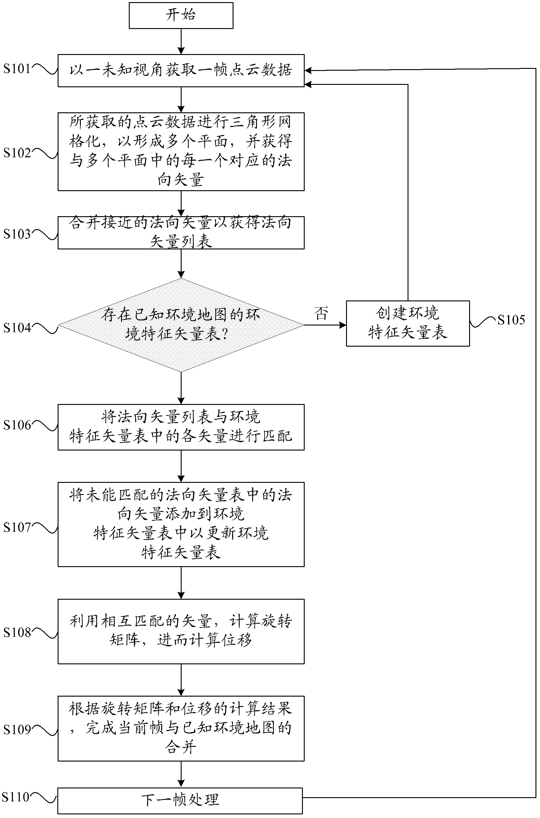
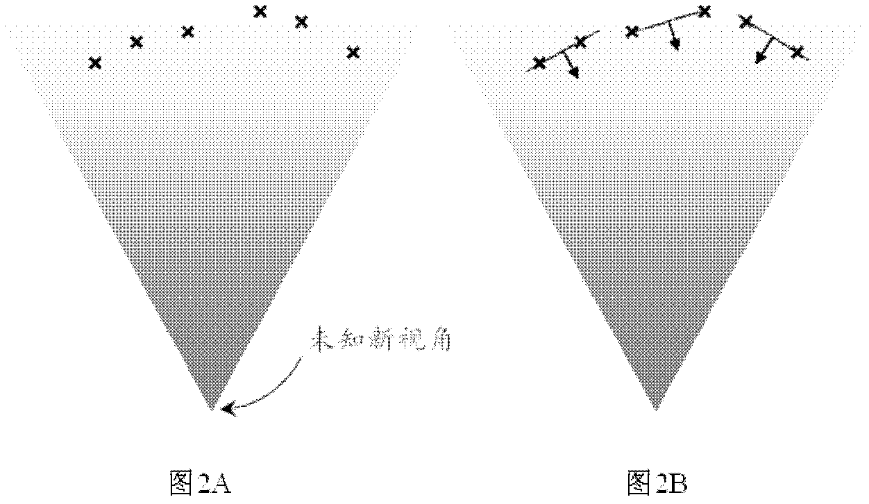
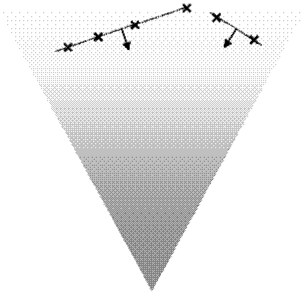
[0023] First, refer to figure 1 A vector-based real-time positioning and map construction method according to an embodiment of the present invention is described, which is used for 3D modeling an...


PUM


Abstract

Provided is a method and device for simultaneous positioning and map building based on vectors. The method is used for conducting three-dimensional (3D) positioning and map building in an unknown environment. The method includes: using an unknown visual angle to obtain a frame of point cloud data; conducting triangular meshing on the obtained point cloud data so as to form a plurality of planes and obtain normal vectors corresponding to each plane of the plurality of planes; combining adjacent normal vectors so as to obtain a normal vector list; obtaining an environment characteristic vector list of a known environment map; matching the normal vector list and vectors in the environment characteristic vector list; adding normal vectors in the normal vector list which is not matched to the environment characteristic vector list so as to update the environment characteristic vector list; calculating a rotation matrix by using matched vectors so as to calculate displacement; and finishing combining of a current frame and the known environment map according to a calculating result of the rotation matrix and the displacement.

Description

technical field [0001] The invention relates to a method and device for real-time positioning and map construction. More specifically, it relates to an instant positioning and map construction method and device capable of reducing calculation load and improving accuracy. Background technique [0002] Simultaneous Localization and Mapping (SLAM) is currently a hot research topic in robot localization. The so-called SLAM is the integration of mobile robot positioning and environmental map creation, that is, the robot builds an incremental environmental map according to its own pose estimation and sensor perception of the environment during the movement process, and uses the map to realize its own positioning. [0003] In SLAM, there are two coordinate systems: the robot coordinate system and the global coordinate system. The pose of the robot refers to its absolute coordinates in the global coordinate system. For example, in a three-dimensional environment, it is recorded as...

Claims


Application Information

Patent Timeline
IPC IPC(8): G06T17/00G09B29/00
Inventor 李南君
Owner LENOVO (BEIJING) CO LTD
Why Eureka
Try Eureka