Real-time data processing and management system for three-dimensional digital earth

A real-time data processing, three-dimensional digital technology, applied in electrical digital data processing, special data processing applications, instruments, etc., can solve problems such as low efficiency, cumbersome real-time data processing, and only focusing on high-precision display and restoration.

Active Publication Date: 2013-06-12
TERRA DIGITAL CREATING SCI & TECH (BEIJING) CO LTD
View PDF4 Cites 2 Cited by
  • Summary
  • Abstract
  • Description
  • Claims
  • Application Information

AI Technical Summary

Problems solved by technology

This means that the real-time processing of data is relatively cumbersome and inefficient
At the same time, the existing digital earth technology only focuses on the high-precision display and restoration of the current scene in the spatial range, and there is no method or system to integrate the influence of the time dimension into the scene

Method used


Image

  • Real-time data processing and management system for three-dimensional digital earth

Examples


Embodiment Construction

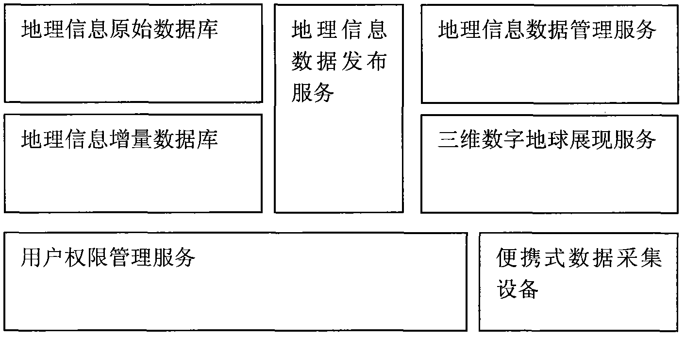
[0013] The specific implementation of the present invention requires the following equipment: a portable data collection device, a geographic information data server, a digital earth display server, and multiple client computers. Specifically, it mainly includes:

[0014] (1) Make original geographic information data, and generate original geographic information data including terrain data, image data, vector data, building models and other data content through general data processing software such as aerial photographs, satellite images, and digital elevation models. And publish the above data in the geographic information data publishing service.

[0015] (2) Load the released original geographic information data through the 3D digital earth display service and display it on the client computer to realize the basic 3D digital earth scene. And based on the three-dimensional digital earth scene, the terrain can be edited, modified and stored.

[0016] (3) Field data collecti...


PUM


Abstract

The invention discloses an application system for processing, managing and comparing data in a three-dimensional geographical information space scene. The data is incrementally stored in a platform, and is incrementally loaded and comparatively displayed in a defining way. The data is published by a data publication platform, and incremental data can be integrated and loaded to a terminal for use at one time according to the requirements of a user. In addition, each piece of incremental data is recorded by a system, and indexes are generated to realize rapid data loading and multi-effect data model comparison.

Description

technical field [0001] The invention relates to a real-time data processing and management system for digital earth, in particular to a system for realizing real-time data processing and management in a three-dimensional digital earth scene. Background technique [0002] With the acceleration of social information construction, 3D digital earth technology has been rapidly developed and widely used in various fields because of its intuitive image and the characteristics of restoring real scenes. [0003] However, in the traditional 3D digital earth system, geographic information data, as an important part of supporting the normal operation of the system, is used in the form of pre-compiled files. This means that the real-time processing of data is relatively cumbersome and inefficient. At the same time, the existing digital earth technology only focuses on the high-precision display and restoration of the current scene in the spatial range, and there is no method or system t...

Claims


Application Information

Patent Timeline
Patent Type & Authority Applications(China)
IPC IPC(8): G06F17/30
Inventor 杨晓峰刘俊伟李蔚蔚杨俊
Owner TERRA DIGITAL CREATING SCI & TECH (BEIJING) CO LTD
Why Eureka
Try Eureka