Picture positioning method and system based on mobile terminal navigation function

A technology of a mobile terminal and a positioning method, applied in the field of mobile communications, can solve the problems of high price, inability to popularize and limit photographic equipment, etc., and achieve the effect of increasing cost

Active Publication Date: 2013-06-19
TENCENT TECH (SHENZHEN) CO LTD
View PDF3 Cites 28 Cited by
  • Summary
  • Abstract
  • Description
  • Claims
  • Application Information

AI Technical Summary

Problems solved by technology

[0003] Although GPS technology has been popularized in daily life, because the camera equipment with GPS navigation function, such as digital cameras, is far more expensive than ordinary camera equipment, this leads to the camera equipment with GPS navigation function not being popularized.
However, the photos taken by ordinary camera equipment do not carry geographical location information, which limits the subsequent management of photos by using the geographical location information of photos.

Method used


Image

  • Picture positioning method and system based on mobile terminal navigation function
  • Picture positioning method and system based on mobile terminal navigation function
  • Picture positioning method and system based on mobile terminal navigation function

Examples


Embodiment Construction

[0029] In order to make the object, technical solution and advantages of the present invention clearer, the present invention will be described in detail below in conjunction with the accompanying drawings and specific embodiments.

[0030] The method provided by the present invention can realize that the photos taken by ordinary camera equipment without navigation function such as GPS navigation function have geographic location information, and the method provided by the present invention is described below:

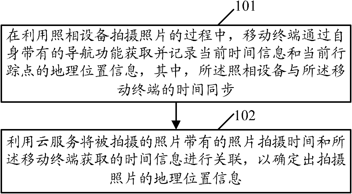
[0031] see figure 1 , figure 1 The flow chart of the method provided by the embodiment of the present invention. Such as figure 1 As shown, the process may include the following steps:

[0032] Step 101, during the process of taking photos with the camera device, the mobile terminal obtains and records the current time information and the geographic location information of the current track point through its own navigation function, wherein the time of the camera de...


PUM


Abstract

The invention provides a picture positioning method and a system based on a mobile terminal navigation function. The method comprises that A, in the process of utilizing of camera equipment to take pictures, a mobile terminal obtains and records current time information and geographic position information of a current tracking point through a self navigation function; and B, a cloud service is utilized to connect picture taking time of taken pictures and time information obtained by the mobile terminal so as to confirm the geographic position information of the taken pictures, wherein the camera equipment is synchronous with time of the mobile terminal.

Description

technical field [0001] The invention relates to mobile communication technology, in particular to a photo positioning method and system based on the navigation function of a mobile terminal. Background technique [0002] In mobile communication technology, GPS is the abbreviation of Global Positioning System in English, and Global Positioning System in Chinese, referred to as the ball position system for short. GPS is a new generation of space satellite navigation and positioning system jointly developed by the U.S. Army, Navy and Air Force in the 1970s. Some military purposes such as emergency communications. After more than 20 years of research and experiments, GPS technology has developed rapidly. Compared with many other wireless positioning technologies, it has the advantages of wide coverage, high positioning accuracy, short positioning time and small positioning dependence. Based on these advantages, it was originally only used in the military. The GPS technology us...

Claims


Application Information

Patent Timeline
Patent Type & Authority Applications(China)
IPC IPC(8): H04W4/02H04W88/02G01S19/42H04M1/72457
CPCH04M2250/52G01S19/51G01S5/16H04W4/185H04N21/422G06F16/9537H04W4/02H04M1/72457H04W4/024H04N21/4524H04W4/029H04W88/18H04N5/91
Inventor 吴永坚
Owner TENCENT TECH (SHENZHEN) CO LTD
Why Eureka
Try Eureka