Waterfowl habitat suitability evaluation method based on combination of remote sensing and geographical information system (GIS)
What is AI technical title?
AI technical title is built by PatSnap AI team. It summarizes the technical point description of the patent document.
An evaluation method and habitat technology, applied in data processing applications, instruments, calculations, etc., can solve problems such as wetland environmental damage
Inactive Publication Date: 2013-07-17
NORTHEAST INST OF GEOGRAPHY & AGRIECOLOGY C A S
View PDF3 Cites 13 Cited by
Summary
Abstract
Description
Claims
Application Information
AI Technical Summary
This helps you quickly interpret patents by identifying the three key elements:
Problems solved by technology
Method used
Benefits of technology
Problems solved by technology
However, the high-intensity agricultural development of humans has severely damaged the wetland environment, and at the same time, it has also caused tremendous pressure on the living environment of wetland waterfowl
Method used
Image
Click on the blue label to locate the original text in one second.
Reading with bidirectional positioning of images and text.
Examples
specific Embodiment approach 1
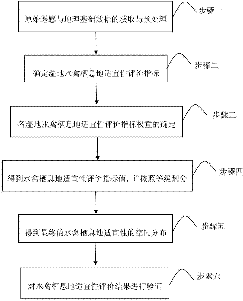
[0015] Specific implementation mode 1: Combination figure 1 versus figure 2 Explain this embodiment:
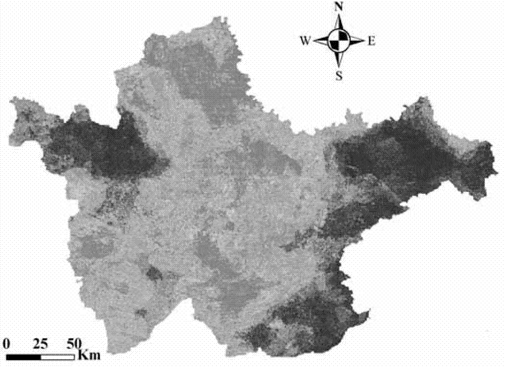
[0016] The western part of Jilin was selected as the experimental area for analysis to evaluate the suitability of the waterfowl habitat in the area in 2010:
[0017] 1. The acquisition and preprocessing of original remote sensing and geographic basic data:
[0018] Mainly include 2010 land use data, DEM data and TM remote sensing image data in western Jilin;
[0019] Preprocessing is mainly to extract vector data of rivers, lakes, roads and residential areas from land use data, extract the slope of western Jilin through DEM data, and use TM remote sensing image operation to obtain NDVI;
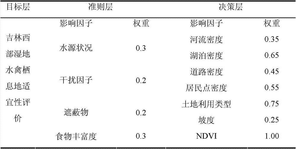
[0020] 2. According to the characteristics of wetland and waterfowl on the habitat, by analyzing the relationship between waterfowl habitat and the environment, determine the suitability evaluation index of wetland waterfowl habitat:
[0021] Select water source conditions (density of rivers and lak...
specific Embodiment approach 2
[0036] Specific embodiment two: This embodiment is different from specific embodiment one in that the evaluation index for determining the suitability of wetland waterfowl habitat described in step two is specifically:
[0037] Select water source conditions, disturbance conditions, shelters and food abundance that directly affect waterfowl habitats as the first-level evaluation indicators;
[0038] Select river density and lake density as the secondary evaluation index of water source status;
[0039] Select road density and residential area density as the secondary evaluation index of interference conditions;
[0040] Select slope and land use type as the secondary evaluation index of shelter;
[0041] NDVI was selected as the secondary evaluation index of food richness. Other steps and parameters are the same as in the first embodiment.
specific Embodiment approach 3
[0042] Specific embodiment three: This embodiment is different from the specific embodiment two in that the NDVI calculation method is:
[0043] NDVI=(NIR-R) / (NIR+R) formula (1)
[0044] Among them, NIR is the near-infrared band of remote sensing images, and R is the red band. Other steps and parameters are the same as in the second embodiment.
PUM
Abstract
The invention discloses a waterfowlhabitat suitability evaluation method based on the combination of remote sensing and a geographical information system (GIS), relates to the wetlandecological environment evaluation and protection technology, and aims to provide an efficient waterfowlhabitat suitability evaluation method. The method comprises the following steps of: 1, acquiring and preprocessing original remote sensing and geographical basic data; 2, analyzing the relation between a waterfowlhabitat and the environment; 3, analyzing the influence degree of each wetland waterfowl habitat suitability evaluation index on the waterfowl habitat, and determining the weight of each wetland waterfowl habitat suitability evaluation index according to a level analysis method; 4, obtaining waterfowl habitat suitability evaluation index values through the spatial analysis technology, and dividing the waterfowl habitat suitability evaluation index values according to the level; 5, obtaining final spatial distribution of waterfowl habitat suitability by adopting the GIS spatial analysis and superposition technology; and 6, acquiring accurate positions of a waterfowl nest site and a rest site, and verifying the waterfowl habitat suitability evaluation result. The method is applied in the field of waterfowl habitat suitability evaluation.
Description
Technical field [0001] The invention relates to wetland ecological environment evaluation and protection technology, in particular to a waterfowl habitat suitability evaluation method based on the combination of remote sensing and GIS. Background technique [0002] In recent years, the degree of incoordination between the stability of the ecological environment and the development of human society has increased significantly, which has caused a series of ecological and environmental problems. For example, habitat loss and habitat fragmentation caused by natural and human factors have seriously affected the survival and development of wild animals. . Wetland waterfowl are an important part of the wetland ecosystem and play an important role in maintaining the stability of the wetland ecosystem. However, human's high-intensity agricultural development has caused severe damage to the wetland environment, and at the same time, it has also caused tremendous pressure on the living env...
Claims
Application Information
Patent Timeline
Application Date:The date an application was filed.
Publication Date:The date a patent or application was officially published.
First Publication Date:The earliest publication date of a patent with the same application number.
Issue Date:Publication date of the patent grant document.
PCT Entry Date:The Entry date of PCT National Phase.
Estimated Expiry Date:The statutory expiry date of a patent right according to the Patent Law, and it is the longest term of protection that the patent right can achieve without the termination of the patent right due to other reasons(Term extension factor has been taken into account ).
Invalid Date:Actual expiry date is based on effective date or publication date of legal transaction data of invalid patent.
IPC IPC(8): G06Q10/00G06Q50/00
Inventor王宗明董张玉刘殿伟任春颖汤旭光贾明明丁智邵田田
OwnerNORTHEAST INST OF GEOGRAPHY & AGRIECOLOGY C A S

