Method for comprehensively evaluating optical remote sensing image quality

An optical remote sensing and image quality technology, applied in image analysis, image data processing, instruments, etc., can solve the problems of measuring the overall quality of remote sensing images that cannot be comprehensively measured

Active Publication Date: 2013-08-28
SATELLITE SURVEYING & MAPPING APPL CENTSASMAC NAT ADMINISTATION OF SURVEYING MAPPING & GEOINFORMATION OF CHINANASG
View PDF3 Cites 14 Cited by
  • Summary
  • Abstract
  • Description
  • Claims
  • Application Information

AI Technical Summary

Problems solved by technology

[0011] At present, whether it is ground resolution GSD, modulation transfer function MTF and average signal-to-noise ratio SNR mean , from the three aspects of geometric resolution, radiation response capability based on continuous spatial frequenc

Method used


Image

  • Method for comprehensively evaluating optical remote sensing image quality
  • Method for comprehensively evaluating optical remote sensing image quality
  • Method for comprehensively evaluating optical remote sensing image quality

Examples


Embodiment Construction

[0020] The present invention will be described in detail below in conjunction with the accompanying drawings and embodiments.

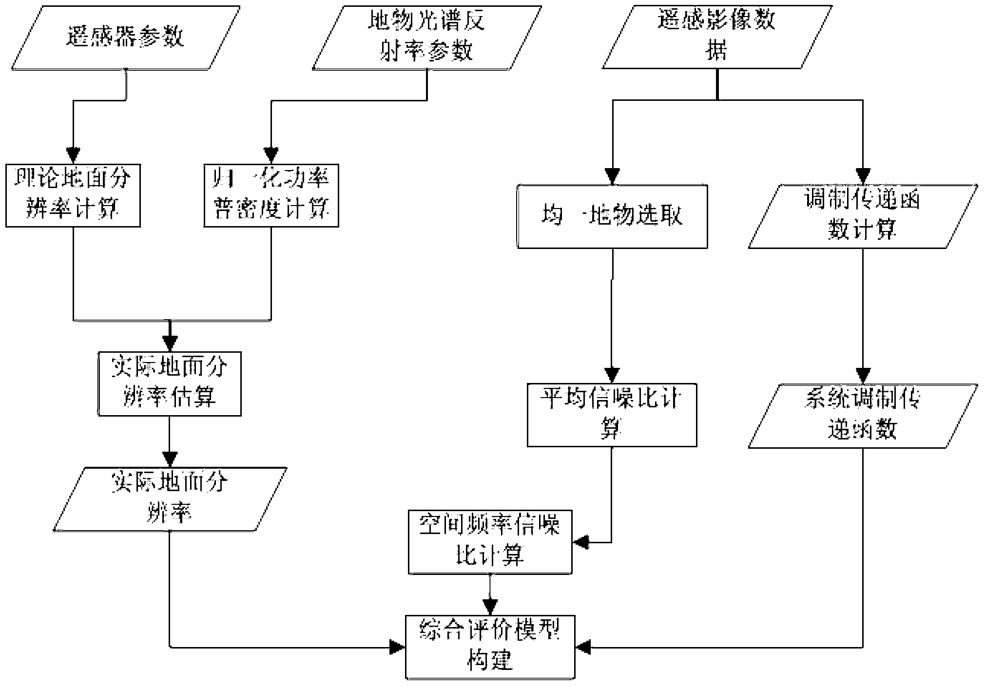
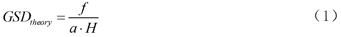
[0021] In the present invention, the actual ground resolution GSD of the optical remote sensing image is real , modulation transfer function (MTF) and signal-to-noise ratio (SNR) are expressed as functions of spatial frequency (u, v) respectively, and a comprehensive evaluation index P :

[0022] P=F(GSD real (u,v),MTF(u,v),SNR(u,v)) (4)

[0023] In the formula, F represents the mapping relationship function between the comprehensive evaluation index P and GSD, MTF, and SNR.

[0024] Such as figure 1 As shown, based on the above-mentioned comprehensive evaluation idea of ​​optical remote sensing image quality, the present invention proposes a comprehensive evaluation method for optical remote sensing image quality, which includes the following steps:

[0025] 1. Estimate the actual ground resolution according to the theoretical ground resolution ...


PUM


Abstract

The invention relates to a method for comprehensively evaluating optical remote sensing image quality. The method for comprehensively evaluating the optical remote sensing image quality comprises the following steps that 1) according to theoretical ground resolution and ground object spectral reflectivity characteristics, actual ground resolution GSD<real> is estimated; 2) according to radiation response of ground objects with different spatial frequencies (u and v), an optical modulation transfer function MTF is established; 3) according to the ground object reflectivity characteristics R and the average signal noise ratio SNR<mean>, the SNR (u and v) based on continuous spatial frequencies is solved; 4) optical remote sensing image quality evaluation indexes integrating the ground resolution GSD<real>, the optical MTF and the SNR are established; 5) according to a set threshold value, the evaluation indexes P are adopted for quality evaluation of different optical remote sensing images, wherein the specific processes are that the evaluation indexes P of the different optical remote sensing images are calculated simultaneously at a certain spatial frequency (u and v), if the evaluation indexes P are greater than the set threshold value, the quality of the optical remote sensing images corresponding to the evaluation indexes P is good, and target information extraction and geometric correction are carried out on the optical remote sensing images with the good quality. The method can be widely applied to quality evaluation of the optical remote sensing images.

Description

technical field [0001] The invention relates to a quality evaluation method, in particular to a comprehensive evaluation method for optical remote sensing image quality. Background technique [0002] Aerospace optical remote sensing images have been widely used in various fields such as agriculture, forestry, environment, geology, ocean, meteorology, surveying and mapping because of their rich information and large coverage. The quality of optical remote sensing images is directly related to the accuracy of remote sensing image information acquisition, and it is also the key to the extraction and application of remote sensing image information. With the improvement and development of aerospace remote sensing imaging technologies such as optics, microwave, and lidar, the number of remote sensing images is increasing rapidly, and the importance of quality evaluation of remote sensing images is becoming increasingly prominent. If all rely on manual subjective evaluation, it wil...

Claims


Application Information

Patent Timeline
IPC IPC(8): G06T7/00
Inventor 唐新明赵世湖付兴科王霞窦显辉
Owner SATELLITE SURVEYING & MAPPING APPL CENTSASMAC NAT ADMINISTATION OF SURVEYING MAPPING & GEOINFORMATION OF CHINANASG
Why Eureka
Try Eureka