
Onboard InSAR data processing method based on BP algorithm and time-varying baseline

A technology of time-varying baseline and BP algorithm, applied in radio wave reflection/re-radiation, radio wave measurement system, utilization of re-radiation, etc., can solve problems such as elevation measurement error and interference phase error, and achieve reduction of elevation error, Expand the effect of the solution

Active Publication Date: 2014-01-01
INST OF ELECTRONICS CHINESE ACAD OF SCI
View PDF2 Cites 24 Cited by
  • Summary
  • Abstract
  • Description
  • Claims
  • Application Information

AI Technical Summary

Problems solved by technology

The approximate processing of the above two aspects will cause interferometric phase errors, which will eventually lead to elevation measurement errors

Method used

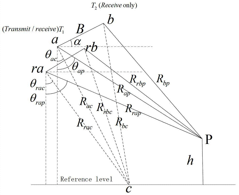
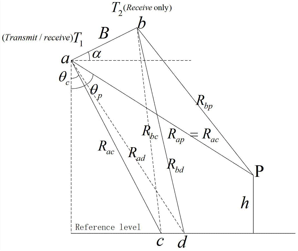

Image

  • Onboard InSAR data processing method based on BP algorithm and time-varying baseline
  • Onboard InSAR data processing method based on BP algorithm and time-varying baseline
  • Onboard InSAR data processing method based on BP algorithm and time-varying baseline

Examples


Embodiment Construction

[0055] In order to make the object, technical solution and advantages of the present invention clearer, the present invention will be further described in detail below in conjunction with specific embodiments and with reference to the accompanying drawings.

[0056] The invention discloses an airborne InSAR data processing method based on BP algorithm and time-varying baseline, which mainly includes BP algorithm imaging, phase unwrapping, time-varying baseline calculation, elevation inversion and other processes.

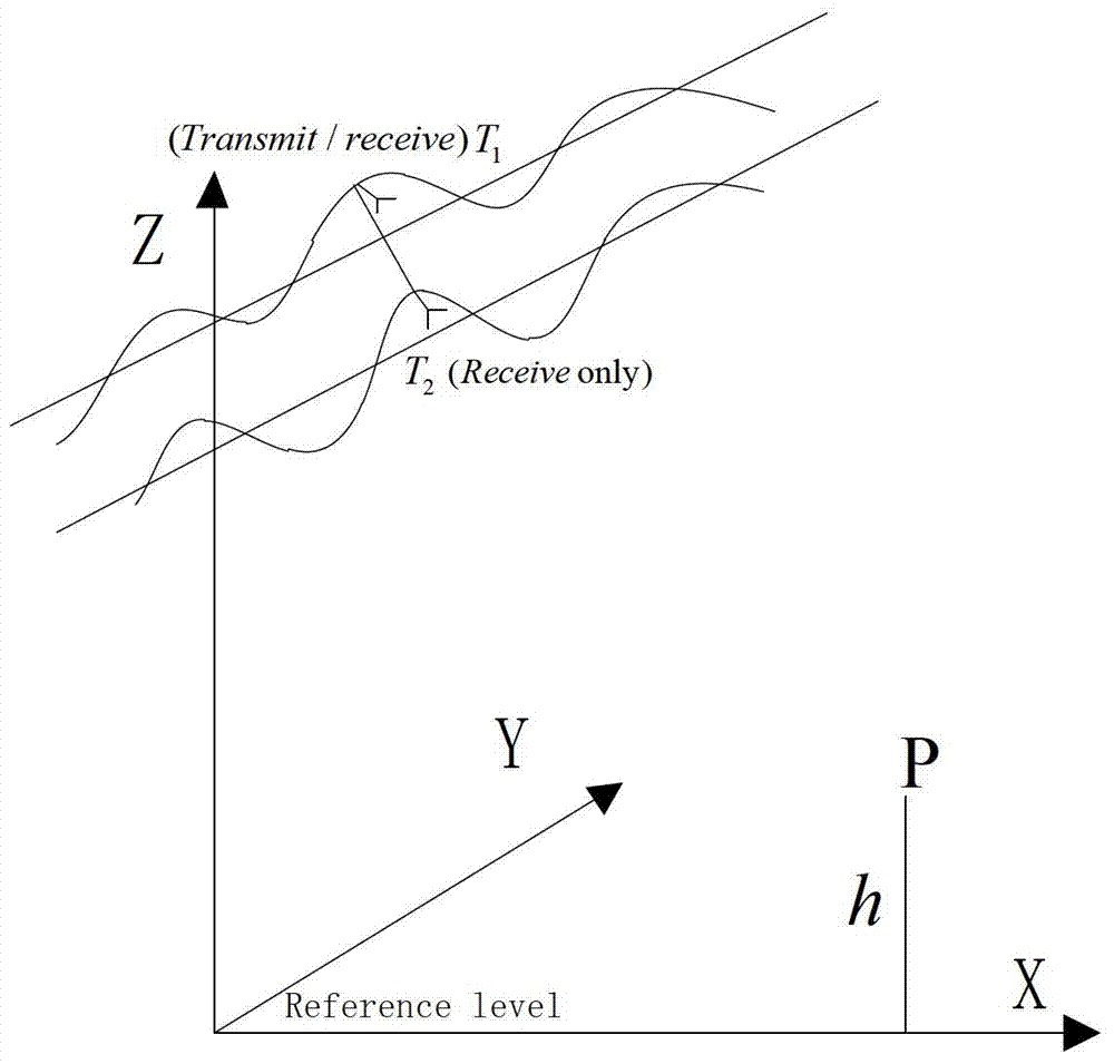
[0057] The side-view imaging geometric model of a single-pass airborne dual-antenna InSAR system is as follows: figure 1 As shown, the system works in the X-band, with a wavelength of 0.03m, adopts the right side view, one transmission and two reception modes, and the antenna T 1 Transmitting a chirp signal, antenna T 1 and T 2 Simultaneous reception, the system works in the case of non-ideal trajectory. In the 150m×150m ground simulation scene, place 25×20 dot m...


PUM


Abstract

The invention discloses an onboard InSAR data processing method based on a BP algorithm and a time-varying baseline, and belongs to the field of radar imaging and InSAR signal processing. According to the onboard InSAR data processing method based on the BP algorithm and the time-varying baseline, the BP imaging algorithm is used for obtaining complex image data of double antennas, an interferometric phase representing the landform elevation is obtained through phase difference processing, phase filtering processing and phase unwrapping processing, and an accurate digital landform elevation is obtained through an elevation inversion method of the time-varying baseline. According to the BP imaging algorithm, an imaging area is divided into grids, and coherent accumulation in the azimuth direction is carried out on data obtained through pulse compression processing in the distance direction pulse by pulse to obtain high-accuracy complex image data according to motion tracks of phase centers of the antennas. According to the elevation inversion method of the time-varying baseline, parameters of the time-varying baseline change along the imaging grids in the azimuth direction point by point, namely, the parameters of the time-varying baseline change along the slow time, and the parameters of the time-varying baseline are determined by the space positions, at each moment, of the phase centers of the two antennas, and comprise the length of the time-varying baseline and the dip angle of the time-varying baseline.

Description

technical field [0001] The invention relates to the technical field of radar imaging and InSAR data processing, and can be used for InSAR data processing in the case of drastic changes in the attitude of the carrier aircraft. Background technique [0002] The side-view imaging geometric model of the airborne dual-antenna InSAR system, such as figure 1 As shown, under normal circumstances, due to atmospheric disturbances, the performance of the airborne platform itself, and other factors, the trajectory of the airborne SAR cannot be an ideal straight line, and it is impossible to ensure that the antenna is parallel to the ground with a stable pointing and a constant speed. linear motion. Traditional SAR imaging requires that the trajectory of the antenna phase center be an ideal straight line. When the motion trajectory of the antenna phase center deviates from the ideal straight line trajectory, motion errors that affect the quality of SAR images will occur, and then phase...

Claims


Application Information

Patent Timeline
Patent Type & Authority Applications(China)
IPC IPC(8): G01S13/90
CPCG01S7/2923G01S13/0209G01S13/5242G01S13/5244G01S13/882G01S13/9023G01S2013/466
Inventor 李道京潘舟浩刘波张清娟
Owner INST OF ELECTRONICS CHINESE ACAD OF SCI
Learn More