Method and module for extracting and interpreting information of remote-sensing image

An information extraction and remote sensing image technology, applied in character and pattern recognition, instruments, computer parts, etc., can solve problems such as lack of random forest classification methods and modules, little research on random forest classification, and lack of in-depth analysis of feature optimization strategies.

Inactive Publication Date: 2014-01-08
CHINESE ACAD OF SURVEYING & MAPPING
View PDF1 Cites 64 Cited by
  • Summary
  • Abstract
  • Description
  • Claims
  • Application Information

AI Technical Summary

Problems solved by technology

The above studies are mainly limited to the pixel-level classification of medium and low-resolution remote sensing images. There are few studies on object-oriented random for

Method used


Image

  • Method and module for extracting and interpreting information of remote-sensing image
  • Method and module for extracting and interpreting information of remote-sensing image
  • Method and module for extracting and interpreting information of remote-sensing image

Examples


Embodiment Construction

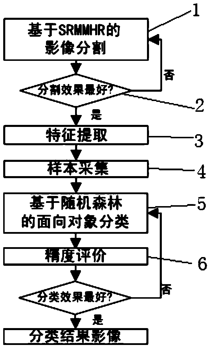
[0031] In order to make the object, technical solution and advantages of the present invention clearer, the present invention will be described in further detail below in conjunction with specific embodiments and with reference to the accompanying drawings.

[0032] The remote sensing image object-oriented information extraction and interpretation method provided by the present invention at least includes the following steps:

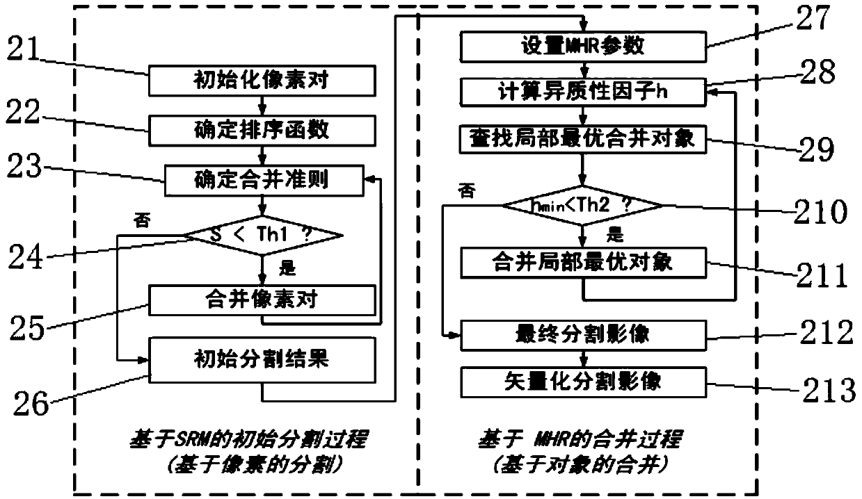
[0033] Step 1: Image segmentation based on SRMMHR. In this step, image segmentation is performed using the statistical region growing and heterogeneity minimum principle combined segmentation method (SRMMHR), and the image is segmented into homogeneous polygonal objects; after the image is segmented into homogeneous polygonal objects, you can use The fractal index evaluates the segmentation quality until a homogeneous polygonal object of good quality is obtained.

[0034] In some embodiments, step 1 may further include an initial segmentation process b...


PUM


Abstract

The invention discloses a method and module for extracting and interpreting information of a remote-sensing image, and provides a geographical element object based automatic interpreting method based on SRMMHR and random forest. The module extracts and interprets the information of the remote-sensing image by the adoption of the method. The method and module for extracting and interpreting the information of the remote-sensing image can achieve effective segmentation of the remote-sensing image, automatic optimization of characteristics, and automatic establishment of a classification rule set; a means which is little in manual intervention, high in degree of automation and high in interpreting precision is provided for extracting and interpreting the information of the remote-sensing image.

Description

technical field [0001] The invention relates to remote sensing image information extraction and interpretation, in particular to an object-oriented classification method. Background technique [0002] Remote sensing image information extraction and interpretation is the process of comprehensively analyzing, comparing, inferring and judging various features on remote sensing images, and finally extracting various ground object information. computer-interactive interpretation, knowledge-based remote sensing image interpretation, intelligent image interpretation (ie automatic interpretation), etc. Remote sensing interpretation has experienced from manual interpretation to semi-automatic interpretation, and is developing in the direction of automation and intelligence. [0003] With the improvement of the spatial resolution of remote sensing images, geographic object based image analysis (GEOBIA) has become the mainstream direction of remote sensing image interpretation. Its mo...

Claims


Application Information

Patent Timeline
IPC IPC(8): G06K9/66G06K9/46G06K9/00
Inventor 李海涛顾海燕韩颜顺余凡杨懿刘佳
Owner CHINESE ACAD OF SURVEYING & MAPPING
Why Eureka
Try Eureka