Three-dimensional laser radar point cloud target segmentation method based on depth map

A three-dimensional laser and target segmentation technology, applied in image analysis, image enhancement, image data processing and other directions, can solve the problems of sparse point cloud data, under-segmentation and noise in point cloud segmentation processing, to achieve point cloud segmentation, improve real-time effects

Active Publication Date: 2019-07-02
CHONGQING UNIV OF POSTS & TELECOMM
View PDF11 Cites 36 Cited by
  • Summary
  • Abstract
  • Description
  • Claims
  • Application Information

AI Technical Summary

Problems solved by technology

The point cloud generated by 3D lidar is a massive, sparse, and disordered collection of points. To realize the recognition of objects around the environment, the first and most important step is to separate the point cloud clusters into independent subsets, each of which corresponds to For targets with physical meaning, this segmentation provides an important basis for subsequent target recognition and tracking. Secondly, the algorithm running time and segmentation effect directly affect the subsequent data processing, but ordinary clustering algorithms cannot meet the real-time performance of point cloud segmentation. Accuracy, so it is necessary to study a fast, accurate and efficient segmentation method
[0004] At present, the research on point cloud segmentation at home and abroad can be roughly divided into two categories: feature-based and ground-based projection. The first type of research directly constructs complex features in 3D space, and then uses clustering algorithms to segment objects. This type of feature-based method Although better segmentation results can be obtained, it often consumes a lot of time and computing resources.
The second type of research projects the point cloud onto the top view plane, and uses the raster elevation map to process it. First, it is judged whether the cell is occupied, and then the obstacles of various geometric shapes are detected by clustering and feature extraction of the occupied cells. This type of method is simple and efficient, but the grid unit parameters cannot be adjusted adaptively, which may easily cause under-segmentation or over-segmentation
[0006] (1) The working characteristics of the lidar and the complexity of the surrounding environment of the unmanned vehicle make the generated point cloud data sparse, uneven and noisy, and the point cloud segmentation often has problems of under-segmentation and over-segmentation
[0007] (2) The existing methods are not very real-time in processing 3D point cloud segmentation, and cannot meet the real-time requirements in unmanned vehicle scenarios

Method used


Image

  • Three-dimensional laser radar point cloud target segmentation method based on depth map
  • Three-dimensional laser radar point cloud target segmentation method based on depth map
  • Three-dimensional laser radar point cloud target segmentation method based on depth map

Examples


Embodiment Construction

[0057] In order to make the purpose, technical solutions and advantages of the present invention clearer, the technical solutions in the embodiments of the present invention will be clearly and completely described below in conjunction with the accompanying drawings. Obviously, the described embodiments are only part of the embodiments of the present invention, and Not all examples. The specific implementation manners of the present invention will be further described in detail below in conjunction with the accompanying drawings and embodiments. The following examples are used to illustrate the present invention, but are not intended to limit the scope of the present invention.

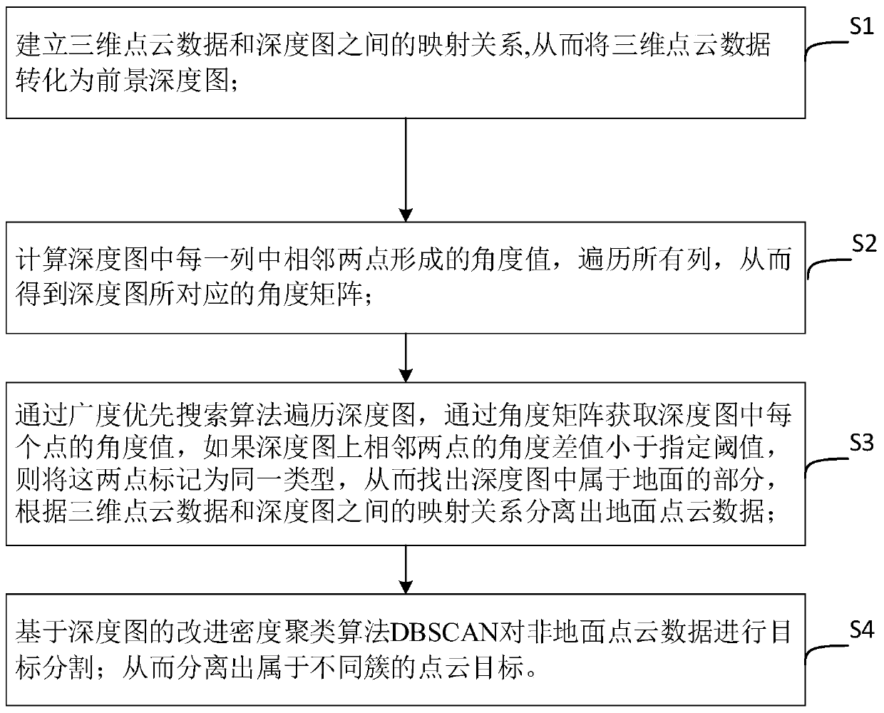
[0058] Such as figure 1 As shown, a kind of three-dimensional lidar point cloud object segmentation method based on depth map that the present invention adopts comprises the following steps:

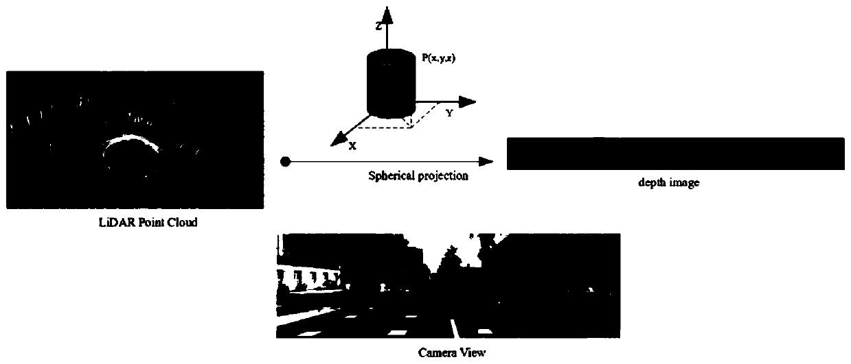
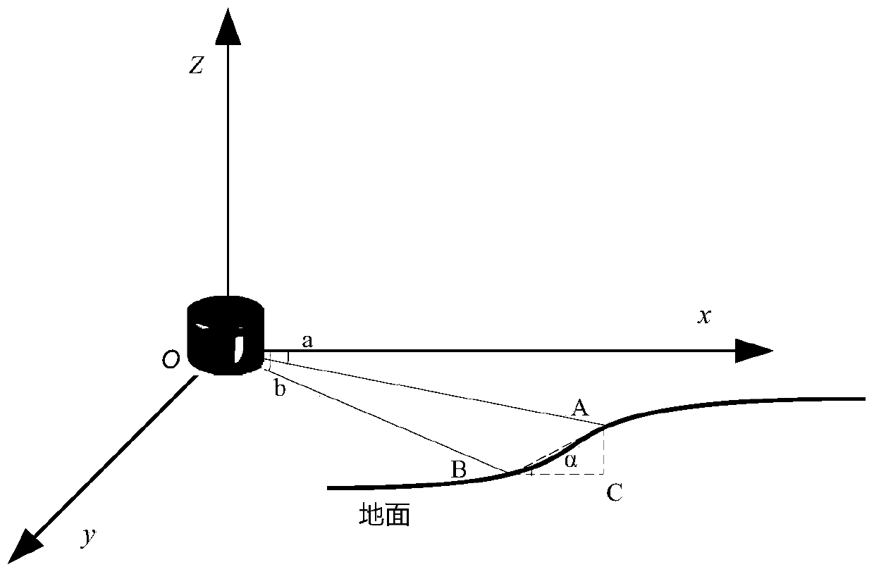
[0059] S1: Establish the mapping relationship between the 3D point cloud data and the depth map, so as to c...


PUM


Abstract

The invention belongs to the technical field of laser radars, and discloses a depth map-based three-dimensional laser radar point cloud target segmentation method, which comprises the following stepsof: converting three-dimensional point cloud data acquired by a three-dimensional laser radar into a two-dimensional depth map; calculating an angle value formed by two adjacent points in each columnin the depth map, and traversing to obtain an angle matrix corresponding to the depth map; traversing the depth map through a breadth-first search algorithm, if the angle difference between two pointson adjacent positions of the depth map is smaller than a specified threshold value, marking the depth map as the same type, thereby finding out the part, belonging to the ground, in the depth map, and removing ground point cloud data according to the mapping relation between the point cloud and the depth map; and carrying out target segmentation on the non-ground point cloud based on an improvedDBSCAN algorithm, and judging whether the point cloud is a core point or not according to an adaptive parameter eps while considering a spatial Euclidean distance and an angle distance. According to the method, the segmentation efficiency on the depth map is improved, the real-time requirement is met, and the problems of under-segmentation and over-segmentation are effectively solved.

Description

technical field [0001] The invention relates to the technical field of laser radar, in particular to a method for segmenting a three-dimensional laser radar point cloud target based on a depth map. Background technique [0002] With the continuous development of artificial intelligence and big data, unmanned driving has also received extensive attention. In the future, unmanned driving technology will play a key role in assisting driving, solving urban problems, and reducing traffic accidents. Usually, in the road environment, the interactive objects of unmanned vehicles are generally vehicles and pedestrian targets. Therefore, stable and real-time detection of targets in complex environments is the research focus of unmanned vehicle technology, and it is also the follow-up road planning and intelligent decision-making of unmanned vehicles. Provides a basis for perception. [0003] At present, in the field of target detection and recognition, there are many kinds of sensors...

Claims


Application Information

Patent Timeline
Patent Type & Authority Applications(China)
IPC IPC(8): G06T7/10G06T7/521G06K9/62
CPCG06T7/10G06T7/521G06T2207/10028G06T2207/30252G06F18/2321
Inventor 王茜竹范小辉许国良李万林雒江涛
Owner CHONGQING UNIV OF POSTS & TELECOMM
Why Eureka
Try Eureka