A Processing Method of Reverse Geocoding Processing System

A geocoding and processing system technology, which is applied in digital data processing, geographic information databases, special data processing applications, etc., can solve problems such as inability to query administrative codes, does not support the development of Chinese maps, and limits the maximum number of queries, etc., to achieve query Fast, precise, and scalable effects

Active Publication Date: 2016-08-31
TIANZE INFORMATION IND
View PDF4 Cites 0 Cited by
  • Summary
  • Abstract
  • Description
  • Claims
  • Application Information

AI Technical Summary

Problems solved by technology

[0004] It is precisely because of the above needs that more and more map service providers at home and abroad (such as Google Maps, Yahoo Maps, Map ABC, Map Bar, Microsoft Maps) have successively carried out research in this area and provided corresponding APIs for Call, but some of these APIs do not support the development of Chinese maps (such as Yahoo Maps, Microsoft Maps), and some have a maximum number of queries per day (such as Google Maps, Microsoft Maps), and can only query road-related information in provinces and cities. However, other relevant information such as administrative codes and road grades cannot be queried. Therefore, there are great restrictions and inconveniences for domestic users.

Method used


Image

  • A Processing Method of Reverse Geocoding Processing System
  • A Processing Method of Reverse Geocoding Processing System
  • A Processing Method of Reverse Geocoding Processing System

Examples


Embodiment Construction

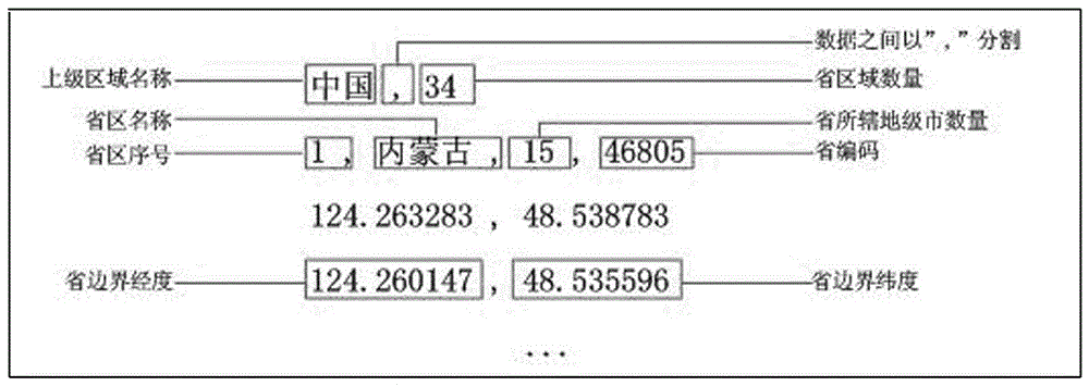
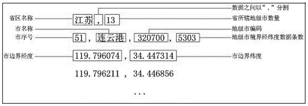
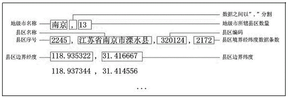
[0051] Refer to attached Figure 1~6 , a processing method for an inverse geocoding processing system, comprising the following steps,

[0052] 1) Obtain geographical location information data from a map in MapInfo format

[0053] The geographic location information data includes the longitude and latitude data of each province in China, the name and number of each province, the latitude and longitude data of each city, the name and number of each city, the latitude and longitude data of each county, the name and number of each county, and the features and roads of each county. Longitude and latitude data, feature names, road names and grades and other related information;

[0054] 2) Process and store the geographic location information obtained in step 1), and the processing and storage structure is as follows,

[0055] The latitude and longitude data of provincial borders are stored in txt file format, and the data are separated by ",". The latitude and longitude data are...


PUM


Abstract

The invention relates to a processing method of an inverse geocoding processing system, which relates to a processing system and a processing method for converting geographic coordinates into corresponding address representations. The processing method is: 1) Obtain geographic location information data; 2) Process and store; 3) Load the data stored in step 2); 4) Find the name corresponding to the coordinates in the cache system in step 3); 4.1) Find the province Name information; 4.2) Find city name information; 4.3) Find district / county name information; 4.4) Find the nearest feature information; 4.5) Find the nearest road information; 5) Combine the query results into a complete address description and return it to the request By.

Description

technical field [0001] The invention relates to a processing method of an inverse geocoding processing system, which relates to a processing system and a processing method for converting geographic coordinates into corresponding address representations. Background technique [0002] In recent years, the automobile industry has become a pillar industry in our country, and the role of automobiles in daily life production has become more and more prominent. However, for those managers who use GIS+GPS technology to manage their large fleets, how can they quickly and efficiently know the precise geographic location of their vehicles at a certain moment, so as to determine whether the vehicle is driving as required. This service of obtaining the geographic location of the vehicle can be called reverse geocoding. [0003] Reverse Geocoding (Reverse Geocoding) can also be called reverse address query, which refers to the process of obtaining the corresponding geographic location fr...

Claims


Application Information

Patent Timeline
Patent Type & Authority Patents(China)
IPC IPC(8): G06F17/30
CPCG06F16/29G06F16/9537G06F16/986
Inventor 周玉巧陈智也陈进薛扬
Owner TIANZE INFORMATION IND
Why Eureka
Try Eureka