Water conservancy planning system

A planning system and water conservancy technology, applied in the field of virtual reality, can solve the problems of inability to dynamically combine and change, unintuitive water conservancy planning and deployment screen, and poor interactivity, and achieve intuitive performance, powerful distance measuring and marking functions, and reduce losses and regrets Effect

Inactive Publication Date: 2014-04-16
浙江贵仁信息科技股份有限公司
View PDF3 Cites 3 Cited by
  • Summary
  • Abstract
  • Description
  • Claims
  • Application Information

AI Technical Summary

Problems solved by technology

[0005] This application provides a water conservancy planning system to solve the problems that the deployment screen of water conservancy planning is not intuitive, has poor interactivity, and cannot be dynamically combined and changed

Method used


Image

  • Water conservancy planning system
  • Water conservancy planning system
  • Water conservancy planning system

Examples


Embodiment Construction

[0076] In order to make the above objects, features and advantages of the present application more obvious and comprehensible, the present application will be further described in detail below in conjunction with the accompanying drawings and specific implementation methods.

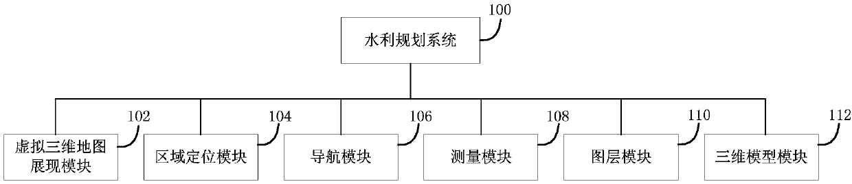
[0077] This application provides a water conservancy planning system, which can display a virtual three-dimensional map on a web page, has three-dimensional (Three Dimensions; 3D) visualization performance, and can visualize water conservancy construction and river network reconstruction, and the performance is intuitive. At the same time, the water conservancy planning system can realize regional positioning and navigation functions, layer data loading and deletion functions, three-dimensional model addition and modification functions, and measurement functions. Both the layer data and the 3D model are stored in the database and can be called quickly. The interface is simple and easy to operate, and user...


PUM


Abstract

The invention provides a water conservancy planning system which comprises a virtual three-dimensional map display module, an area locating module, a navigation module, a measuring module, a layer module and a three-dimensional model module. The virtual three-dimensional map display module is used for displaying a virtual three-dimensional map on a webpage, the area locating module is used for carrying out area locating on the virtual three-dimensional map, the navigation module is used for adjusting the direction, the angle and the size of the virtual three-dimensional map, the measuring module is used for measuring line segments, the area and the reservoir storage on the virtual three-dimensional map, the layer module is used for loading layer data to the virtual three-dimensional map, and the three-dimensional model module is used for loading a three-dimensional model to the virtual three-dimensional map. The water conservancy planning system can solve the problems that in water conservancy planning and deploying, picture showing is not visual, interaction is poor, and the result is solidified and can not be subjected to dynamic combination.

Description

technical field [0001] This application relates to the field of virtual reality technology, in particular to a water conservancy planning system. Background technique [0002] Reasonable planning and deployment of water conservancy can effectively prevent and control floods and droughts, and rationally develop and utilize water and soil resources. At present, the water conservancy department usually adopts the following methods when carrying out water conservancy planning and deployment: on traditional media (such as paper), to display water conservancy planning and deployment with graphics; or to use electronic sand table to display water conservancy planning and deployment. [0003] Using traditional means to carry out water conservancy planning and deployment, the results of water conservancy planning and deployment are usually displayed on traditional media (such as paper) with renderings, floor plans, etc. Government planning departments, project developers, engineering...

Claims


Application Information

Patent Timeline
IPC IPC(8): G06Q50/06
Inventor 桂发二
Owner 浙江贵仁信息科技股份有限公司
Why Eureka
Try Eureka