A multi-platform point cloud data fusion method

A technology of point cloud data and fusion method, which is applied in the fields of surveying, mapping and engineering

Active Publication Date: 2017-02-08
星际空间(天津)科技发展有限公司
View PDF1 Cites 0 Cited by
  • Summary
  • Abstract
  • Description
  • Claims
  • Application Information

AI Technical Summary

Problems solved by technology

[0004] At present, there is no technology that can fuse point cloud data collected based on different platforms to make up for the limitations of each single method, and finally obtain 360-degree all-round laser point cloud data, providing a comprehensive basis for data production Data; integrated management of multi-platform, multi-time point cloud data collection helps to achieve multi-temporal and multi-platform data integration; it can bring new data support for the production of 3D body frame models, and lay the foundation for the establishment of real and detailed 3D scenes

Method used


Image

  • A multi-platform point cloud data fusion method
  • A multi-platform point cloud data fusion method
  • A multi-platform point cloud data fusion method

Examples


Embodiment 1

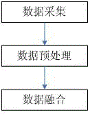
[0062]figure 1 A schematic flow diagram of the multi-platform point cloud data fusion method provided in this embodiment, as shown in the figure, the method is as follows:

[0063] S1 data collection: Obtain three-dimensional data of ground objects and landforms in the target area through data collection equipment set up on different platforms, and obtain raw data with different precision, density and orientation;

[0064] S2 data preprocessing: Preprocessing the collected raw data respectively to obtain the preprocessed point cloud data;

[0065] S3 data fusion: compare the accuracy of the preprocessed point cloud data, and based on the point cloud data with higher accuracy, correct and analyze the data with lower accuracy, obtain the point cloud data conversion model, and perform correction and fusion.

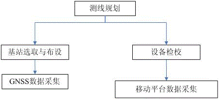
[0066] Such as image 3 As shown, a multi-platform point cloud data fusion method, wherein the specific steps of data collection are:

[0067] S1.1) Preparation before col...

Embodiment 2

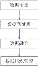
[0123] figure 2 A schematic flow diagram of the multi-platform point cloud data fusion method provided in this embodiment, as shown in the figure, the method is as follows:

[0124] S1 data collection: Obtain three-dimensional data of ground objects and landforms in the target area through data collection equipment set up on different platforms, and obtain raw data with different precision, density and orientation;

[0125] S2 data preprocessing: Preprocessing the collected raw data respectively to obtain the preprocessed point cloud data;

[0126] S3 data fusion: compare the accuracy of the preprocessed point cloud data, and based on the point cloud data with higher accuracy, correct and analyze the data with lower accuracy, obtain the point cloud data conversion model, and perform corrective fusion;

[0127] S4 data organization and management: extract key points from the fused point cloud data, and carry out engineering organization and management of key points.

[0128]...

Embodiment 3

[0201] figure 2 A schematic flow diagram of the multi-platform point cloud data fusion method provided in this embodiment, as shown in the figure, the method is as follows:

[0202] S1 data collection: Obtain three-dimensional data of ground objects and topography in the target area through data collection equipment set up on different platforms, and obtain raw data of different precision, density and orientation;

[0203] S2 data preprocessing: Preprocessing the collected raw data respectively to obtain the preprocessed point cloud data;

[0204] S3 data fusion: compare the accuracy of the preprocessed point cloud data, and based on the point cloud data with higher accuracy, correct and analyze the data with lower accuracy, obtain the point cloud data conversion model, and perform corrective fusion;

[0205] S4 data organization and management: extract key points from the fused point cloud data, and carry out engineering organization and management of key points.

[0206] ...


PUM


Abstract

The invention discloses a multi-platform point cloud data fusion method and relates to the fields of mapping and engineering surveying. The method comprises the following steps: data collecting: original data of ground objects and landform in an object region are obtained through data acquisition equipment and fixed type ground laser scanning equipment carried on mobile platforms; data preprocessing: preprocessing work such as engineered organizational management, filtering and noise reduction and the like are respectively performed on the collected original data; data fusion: after filtering and noise reduction to the point cloud data are performed, the point cloud data is accurately analyzed, point cloud data with highest accuracy is used as a basis to carry out accuracy rectification on other data, in addition, coordinate transformation of data obtained by the fixed type ground laser scanning equipment is achieved on the basis of the mobile platforms, and that point coordinate transformation without field control is achieved. The multi-platform point cloud data fusion method has the advantages that point cloud data collected by different platforms at different time are fused, so as to enable respective advantage complementation to be achieved, further comprehensive utilization of date is further improved, and fusion using of the multi-platforms and multi-scale point cloud data can be achieved.

Description

technical field [0001] The invention relates to the fields of surveying and mapping and engineering, and in particular to a multi-platform point cloud data fusion method for obtaining point cloud data of different densities based on different acquisition platforms and performing precision correction and fusion of the above point cloud data to form three-dimensional spatial information. Background technique [0002] With the continuous and rapid development of social economy, airborne, vehicle-mounted, and ground-based lidar equipment can collect point cloud data of different ranges, different precision, and different densities, which can be used to generate digital ground models for terrain mapping, engineering surveying, and urban and rural planning. etc. to provide basic data; in addition, point cloud data can be filtered and classified to achieve special feature extraction, such as buildings and vegetation, because point cloud data contains positioning information, it can ...

Claims


Application Information

Patent Timeline
Patent Type & Authority Patents(China)
IPC IPC(8): G06F17/30
CPCG06F16/215G06F16/29
Inventor 王国飞闫继扬田春来江贻芳李建平周泽兵李文棋陈春明
Owner 星际空间(天津)科技发展有限公司
Why Eureka
Try Eureka