Planting area remote sensing estimation method for grain subsidy accounting of prefecture level and county level

A technology of area and prefecture and city, which is applied in the field of remote sensing estimation of grain planting area, which can solve problems such as difficult to guarantee data quality, waste of national financial funds, false reporting, etc.

Active Publication Date: 2014-04-30
INST OF REMOTE SENSING & DIGITAL EARTH CHINESE ACADEMY OF SCI
View PDF5 Cites 14 Cited by
  • Summary
  • Abstract
  • Description
  • Claims
  • Application Information

AI Technical Summary

Problems solved by technology

[0003] Estimating the planting area of ​​crops through statistical methods is the main method of the statistical department at present, but due to sample layout, ground survey and statistical errors, as well as subjective facto

Method used


Image

  • Planting area remote sensing estimation method for grain subsidy accounting of prefecture level and county level
  • Planting area remote sensing estimation method for grain subsidy accounting of prefecture level and county level
  • Planting area remote sensing estimation method for grain subsidy accounting of prefecture level and county level

Examples


Embodiment Construction

[0063] The present invention will be further described with reference to the accompanying drawings:

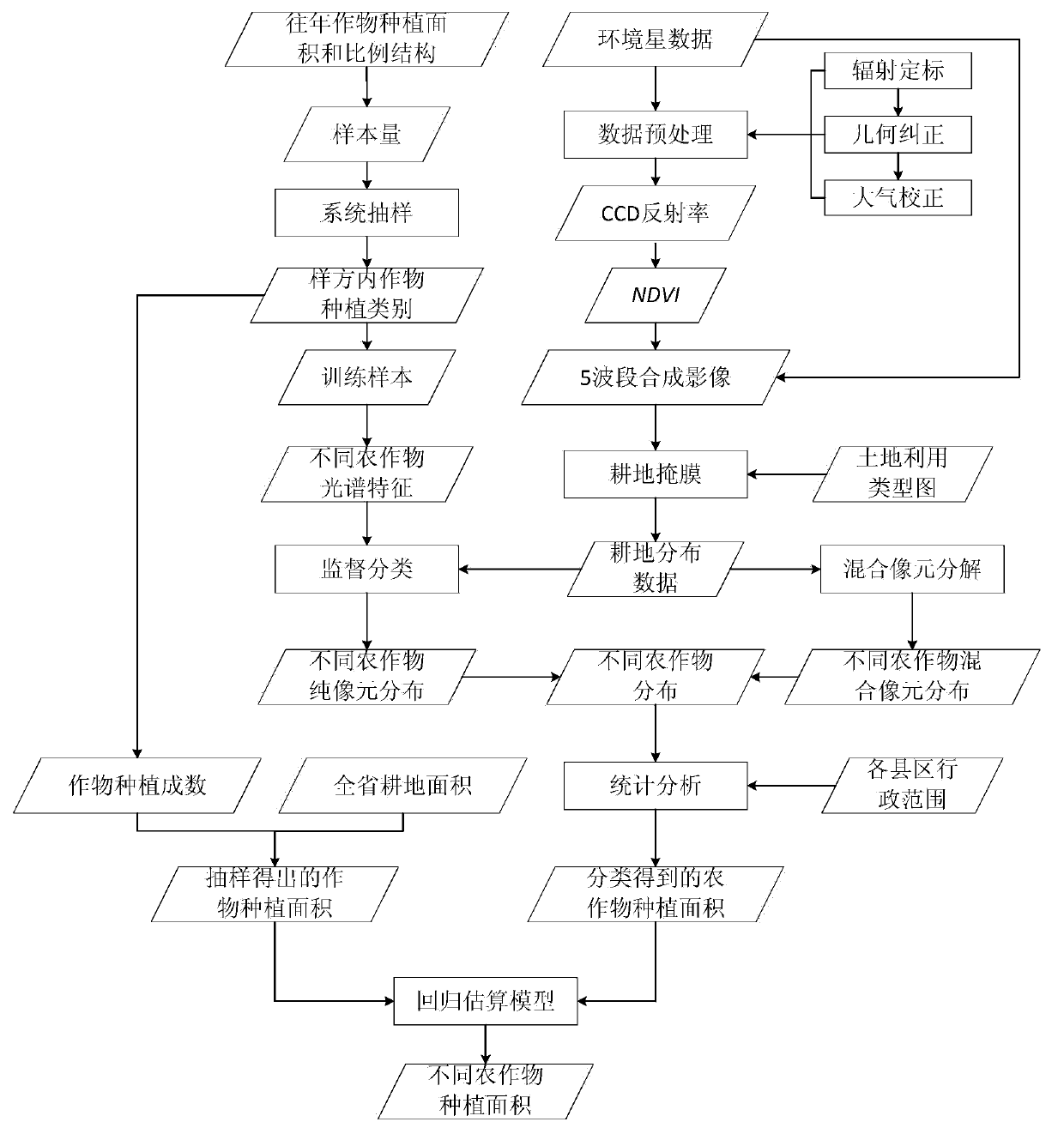
[0064] like figure 2 As shown, the remote sensing estimation method of planting area used for the calculation of grain subsidies at the prefecture and county levels of the present invention comprises the following steps:

[0065] Step P1: conduct a sample survey on the planting area of ​​grain crops in the target province.

[0066] Based on the historical crop planting area and planting proportion structure in the study area, a provincial area sampling frame was established, and the sample size was calculated according to the planting structure, expected accuracy and reliability of grain crops, and the samples were distributed systematically. Specifically include the following steps:

[0067] Step P101: Use ArcGIS and other geographic information system (GIS) tools to generate a rectangular grid. The size of the rectangular grid is: length and width are both 5 kilometers, a...


PUM


Abstract

The invention discloses a planting area remote sensing estimation method for grain subsidy accounting of the prefecture level and the county level. The method comprises the following steps: P1, conducting sample investigation on the planting area of grain corps in a province; P2, selecting and preprocessing a remote-sensing image; P3, conducting remote sensing recognition on the grain crops; P4, processing mixed pixels; P5, establishing a grain crop planting area estimation model, and estimating the planting area of large quantity of the grain crops in district-and-county-level administrative units.

Description

technical field [0001] The invention relates to a remote sensing monitoring method, in particular to a remote sensing estimation method for grain planting area used for grain subsidy accounting at the prefecture and county levels. Background technique [0002] The grain direct subsidy policy is one of the most important government policies to support agriculture in my country in recent years. With the continuous increase of subsidy funds for farmers, the government's management of subsidy funds also needs to be strengthened. At present, all provinces in my country have launched a subsidy policy based on grain planting area. In order to implement grain planting subsidies, it is necessary to calculate the grain planting area of ​​prefecture-level and county-level administrative units. At present, the method of statistical reporting is mainly adopted, and the counties report the grain planting area, and then the provincial finance department calculates the subsidy amount acco...

Claims


Application Information

Patent Timeline
IPC IPC(8): G06F19/00
Inventor 李强子张焕雪杜鑫刘吉磊王红岩
Owner INST OF REMOTE SENSING & DIGITAL EARTH CHINESE ACADEMY OF SCI
Why Eureka
Try Eureka