Inland river hydrological and water administrative ship real-time location monitoring system and method

A monitoring system and real-time positioning technology, which is applied in traffic control systems, ship traffic control, instruments, etc., can solve the problems of inland river hydrology and water administration ship positioning and real-time monitoring difficulties, so as to maintain the order of sand mining and maintain the flow of rivers. The effect of flood safety and efficient management

Inactive Publication Date: 2014-05-07
YELLOW RIVER INST OF HYDRAULIC RES YELLOW RIVER CONSERVANCY COMMISSION
View PDF7 Cites 18 Cited by
  • Summary
  • Abstract
  • Description
  • Claims
  • Application Information

AI Technical Summary

Problems solved by technology

[0003] The technical problem to be solved by the present invention is to provide a real-time positioning and monitoring system and method for inland river hydrology

Method used


Image

  • Inland river hydrological and water administrative ship real-time location monitoring system and method

Examples


Example Embodiment

[0027] In order to solve the problem of difficulty in positioning and real-time monitoring of hydrological and hydrological vessels in inland rivers, the purpose of the present invention is to provide a positioning and monitoring system for hydrological and hydrological vessels with high positioning accuracy, easy operation, and real-time communication, thereby enhancing the monitoring of vessels operating on rivers. Management, to achieve accurate positioning and real-time monitoring of hydrological and hydrological vessels, to improve the accuracy of the Yellow River hydrological survey, improve the efficiency of water administration law enforcement, strengthen the supervision of sand mining vessels, reduce the occurrence of water violations and ensure the smooth operation of the river Technical Support.

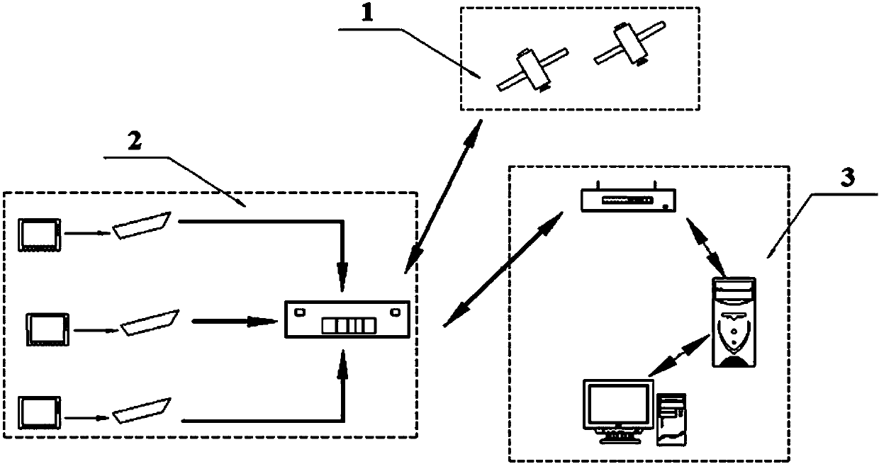
[0028] This inland river hydrology and water administration vessel real-time positioning monitoring system is composed of a satellite system, terminal equipment system and bac...


PUM

PropertyMeasurementUnit
Widthaaaaaaaaaa

Abstract

The invention discloses an inland river hydrological and water administrative ship real-time location monitoring system. The system comprises a satellite system (1), a terminal equipment system (2) and a background monitoring system (3). The real-time location monitoring system can realize real-time communication and location monitoring of the terminal equipment system (2) and the background monitoring system (3) through the satellite system (1). The invention further discloses an inland river hydrological and water administrative ship real-time location monitoring method. Through cooperation with an inland river sand excavation management method, the ideas that an early warning buffer zone with the width of 50 meters is established and the ship navigation line measurement allowable deviation range is displayed in two modes are put forward in the method for the first time, the early warning buffer zone and the line measurement allowable deviation range are displayed in a GIS visualized dynamic monitoring application platform of the background monitoring system (3), and the information recording precision can be measured in seconds. Through the inland river hydrological and water administrative ship real-time location monitoring system and method, the functions of locating and tracking, boundary violation alarm, monitoring and dispatching, yawing warning and trajectory analysis on monitored ships are achieved.

Description

Technical field [0001] The invention relates to the field of positioning monitoring, in particular to a real-time positioning monitoring system for hydrological and hydrological vessels based on Beidou satellite navigation system and GPS navigation system, which can realize real-time communication and positioning of hydrological survey vessels, water administration law enforcement vessels, and sand mining vessels monitor. Background technique [0002] In modern society, various industries are developing vigorously, and many industries are inseparable from real-time monitoring and positioning. Currently, the GPS global satellite positioning system developed by the United States is commonly used. The accuracy of the system is limited in the use process; and at the national level, for the sake of national security and information confidentiality, the system cannot be completely relied on. Therefore, the development of Beidou navigation system is very necessary. The Beidou-2 (BD2) ...

Claims


Application Information

Patent Timeline
IPC IPC(8): G08G3/00
Inventor 杨勇李永强张雷郑军陈豪张彬郭巧玲杨云松
Owner YELLOW RIVER INST OF HYDRAULIC RES YELLOW RIVER CONSERVANCY COMMISSION
Why Eureka
Try Eureka