A real-time atmospheric point dispersion calibration method

A calibration method and atmospheric point technology, applied in the field of remote sensing detection, can solve the problems of complex structure, difficult to integrate the main imaging system, large size of the instrument, etc., and achieve the effect of high precision and low engineering requirements.

Inactive Publication Date: 2016-08-24
ZHEJIANG UNIV
View PDF1 Cites 0 Cited by
  • Summary
  • Abstract
  • Description
  • Claims
  • Application Information

AI Technical Summary

Problems solved by technology

The above two systems are often complex in structure and large in size, so it is difficult to integrate into the main imaging system to improve the imaging quality. At the same time, the data obtained by the above two instruments are based on long-term statistical laws and assumptions to invert optical parameters. Therefore, The reliability and accuracy of the obtained atmospheric effective optical data are relatively low

Method used


Image

  • A real-time atmospheric point dispersion calibration method
  • A real-time atmospheric point dispersion calibration method
  • A real-time atmospheric point dispersion calibration method

Examples


Embodiment Construction

[0030] The present invention will be further described below in conjunction with accompanying drawing.

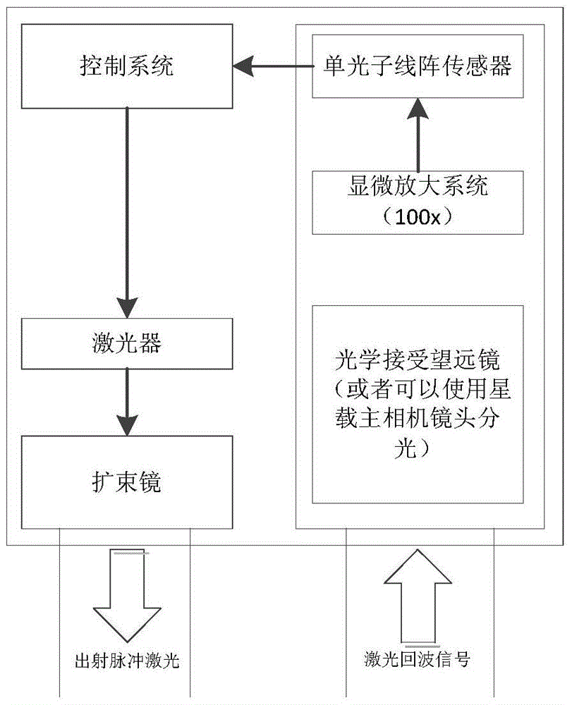
[0031] like figure 1 Shown, the concrete parameter of the system main element that the present invention uses is as table 1:

[0032] Table 1

[0033]

[0034] According to the proposed parameter index, the laser emitting unit can choose the APL-4000 series laser from Attodyne Company of Canada, and the signal receiver can choose MPPC (multi-pixel photon counter) of Hamamatsu Company as the detection element. At the same time, assuming that the satellite orbit is 300km, the spot diameter on the ground is 1.35m, and each detection pixel corresponds to 0.1m on the ground. Assuming that the reflectivity is 0.2, when the visibility is light and hazy (the optical thickness is 0.6), according to the lidar echo equation:

[0035] P ( R ) = P ( 0 ) ...


PUM


Abstract

The invention discloses an atmospheric point spread function real-time calibration method. The method comprises the steps that (1) system pulse laser is emitted, (2) a beam goes through downward scattering of atmosphere, ground reflection and upward scattering of atmosphere and returns to an optical receiving part of the system finally, (3) a signal collected through a linear array photon detector and a function of original emission light wave are subjected to solution by using Fourier transformation to obtain a pixel level point spread function, and (4) interpolation is carried out through the generalized Gauss distribution to obtain a point spread function in sub-pixel precision. According to the method, the point spread function in the atmosphere is obtained in real time based on a method of laser direct detection, and through the curve fitting and interpolation of a final point spread function, the point spread function in sub-pixel level precision is obtained. The method can be applied to the field of remote sensing high precision imaging, and the accurate point spread function is provided for the high resolution correction of a space-borne image.

Description

technical field [0001] The invention belongs to the technical field of remote sensing detection and relates to a real-time atmospheric point diffusion calibration method using laser detection. Background technique [0002] In the process of remote sensing imaging, optical radiation not only depends on the observation target, but also is affected by the absorption and scattering of various gases and aerosol particles in the atmosphere. Inevitable atmospheric interference in the imaging process usually leads to the degradation of imaging quality, especially in the case of optical remote sensing earth observation based on satellites, stratosphere, and aviation platforms (especially sideways, oblique shooting), the imaging distance is very far and thus The optical thickness of the atmosphere increases, resulting in a decrease in the contrast and color saturation of the captured image, and the loss of target detail information, thereby greatly reducing the recognizability of the ...

Claims


Application Information

Patent Timeline
Patent Type & Authority Patents(China)
IPC IPC(8): G06T7/00
Inventor 徐之海林光张秀达严惠民倪旭强冯华君
Owner ZHEJIANG UNIV
Why Eureka
Try Eureka