Road early warning method and road early warning system based on satellite positioning

A technology of satellite positioning and early warning system, applied in anti-collision system, traffic signal control, etc., can solve the problems of not being able to know the road ahead in time, the utilization rate of the expressway is declining, and the distance between vehicles showing the direction of the roadway, etc.

Inactive Publication Date: 2016-03-16
LINZE ZHONGYUN DATA CO LTD
View PDF5 Cites 0 Cited by
  • Summary
  • Abstract
  • Description
  • Claims
  • Application Information

AI Technical Summary

Problems solved by technology

[0002] When the existing satellite positioning system is applied to road traffic, it is usually to set up a navigator on the vehicle to provide driving route guidance for the vehicle, or to know the current running position of each vehicle from the central control room, but it cannot realize the roadway ahead. The occupancy status of other vehicles, the driving status of other vehicles, and the distance between vehicles are displayed in a long-distance, continuous, and dynamic manner. When the atmospheric visibility conditions are poor, such as foggy weather, vehicle lighting, street lights, existing highway signal systems and reflective The signs cannot clearly show the direction of the roadway and the distance between vehicles to the driver of the vehicle. Due to the limitation of the driver's sight distance, they cannot understand the road conditions ahead in time, which may easily cause traffic accidents; Closing roads to avoid traffic accidents is common in expressway traffic; this will reduce the utilization rate of expressways and bring inconvenience to people's daily life and economic activities

Method used


Image

  • Road early warning method and road early warning system based on satellite positioning
  • Road early warning method and road early warning system based on satellite positioning
  • Road early warning method and road early warning system based on satellite positioning

Examples


Embodiment Construction

[0033] Embodiment of the present invention is described below with accompanying drawing as example:

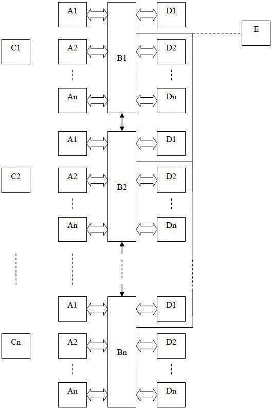
[0034] figure 1 It is a structural diagram of the road early warning system according to an embodiment of the present invention, wherein:

[0035] A1-An is the road signal, the road signal is arranged at a certain interval along the center line of each roadway, or arranged at a certain interval along the two sides of each roadway, that is, along the boundary line of each roadway and the edge of each roadway Lines are arranged at certain intervals to set up road signals; B1-Bn are satellite positioning and calibration repeating stations, which are set at certain intervals along the road line, and their wireless communication ranges are interlinked to cover all lanes of the entire road surface; C1- Cn is a vehicle-mounted satellite positioning signal, which is set on the vehicle entering the road; D1-Dn is an intelligent road traffic sign, which is set along the road; E is a c...


PUM


Abstract

The invention introduces a road warning method based on satellite positioning which is realized by a road warning system consisting of a vehicle-mounted satellite positioning signal machine, a pavement signal machine, a satellite calibration repeater station, an intelligent road traffic signboard, a central monitor and a communication transmission system. The method can guide traffic for the driving vehicles and forecast the approaching distance and warn and mark the vehicles on a road of a highway pavement in a haze weather state to avoid accidents so as to realize the purpose of assisting safe driving and improving the utilization ratio of highway. The method and system have the characteristics of convenient implementation and strong practicality.

Description

technical field [0001] The invention relates to a road early warning method and a road early warning system based on satellite positioning, and belongs to the field of road traffic control. Background technique [0002] When the existing satellite positioning system is applied to road traffic, it is usually to set up a navigator on the vehicle to provide driving route guidance for the vehicle, or to know the current running position of each vehicle from the central control room, but it cannot realize the roadway ahead. The occupancy status of other vehicles, the driving status of other vehicles, and the distance between vehicles are displayed in a long-distance, continuous, and dynamic manner. When the atmospheric visibility conditions are poor, such as foggy weather, vehicle lighting, street lights, existing highway signal systems and reflective The signs cannot clearly show the direction of the roadway and the distance between vehicles to the driver of the vehicle. Due to ...

Claims


Application Information

Patent Timeline
Patent Type & Authority Patents(China)
IPC IPC(8): G08G1/07G08G1/16
Inventor 贾其煜张波董治斌赵耘博
Owner LINZE ZHONGYUN DATA CO LTD
Why Eureka
Try Eureka