Integral orientation method of ground scanning point cloud through linear fitting

A linear fitting and scanning point technology, which is applied in cross-section drawing, measuring devices, surveying and navigation, etc., can solve the problems of heavy field workload, lack of overall convincing power, uneven accuracy, etc.

Inactive Publication Date: 2014-09-17
SHANDONG UNIV OF TECH
View PDF5 Cites 9 Cited by
  • Summary
  • Abstract
  • Description
  • Claims
  • Application Information

AI Technical Summary

Problems solved by technology

Compared with the continuous splicing (ICP method), the independent model method has higher orientation accuracy, reasonable target distribution, and easy operation, but has the following disadvantages: ①Large field workload
③ The accuracy of each station is not uniform, the difference is large, and the overall convincingness is lacking in the accuracy evaluation

Method used


Image

  • Integral orientation method of ground scanning point cloud through linear fitting
  • Integral orientation method of ground scanning point cloud through linear fitting
  • Integral orientation method of ground scanning point cloud through linear fitting

Examples


Embodiment Construction

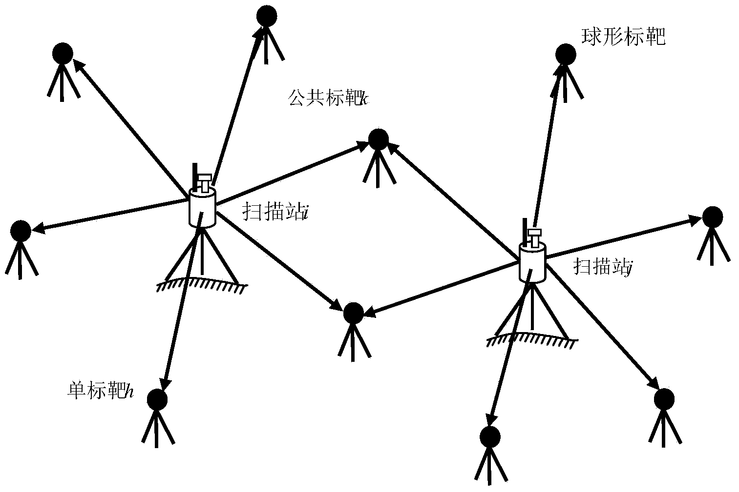
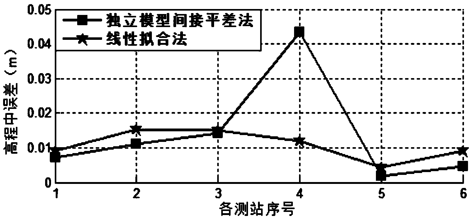
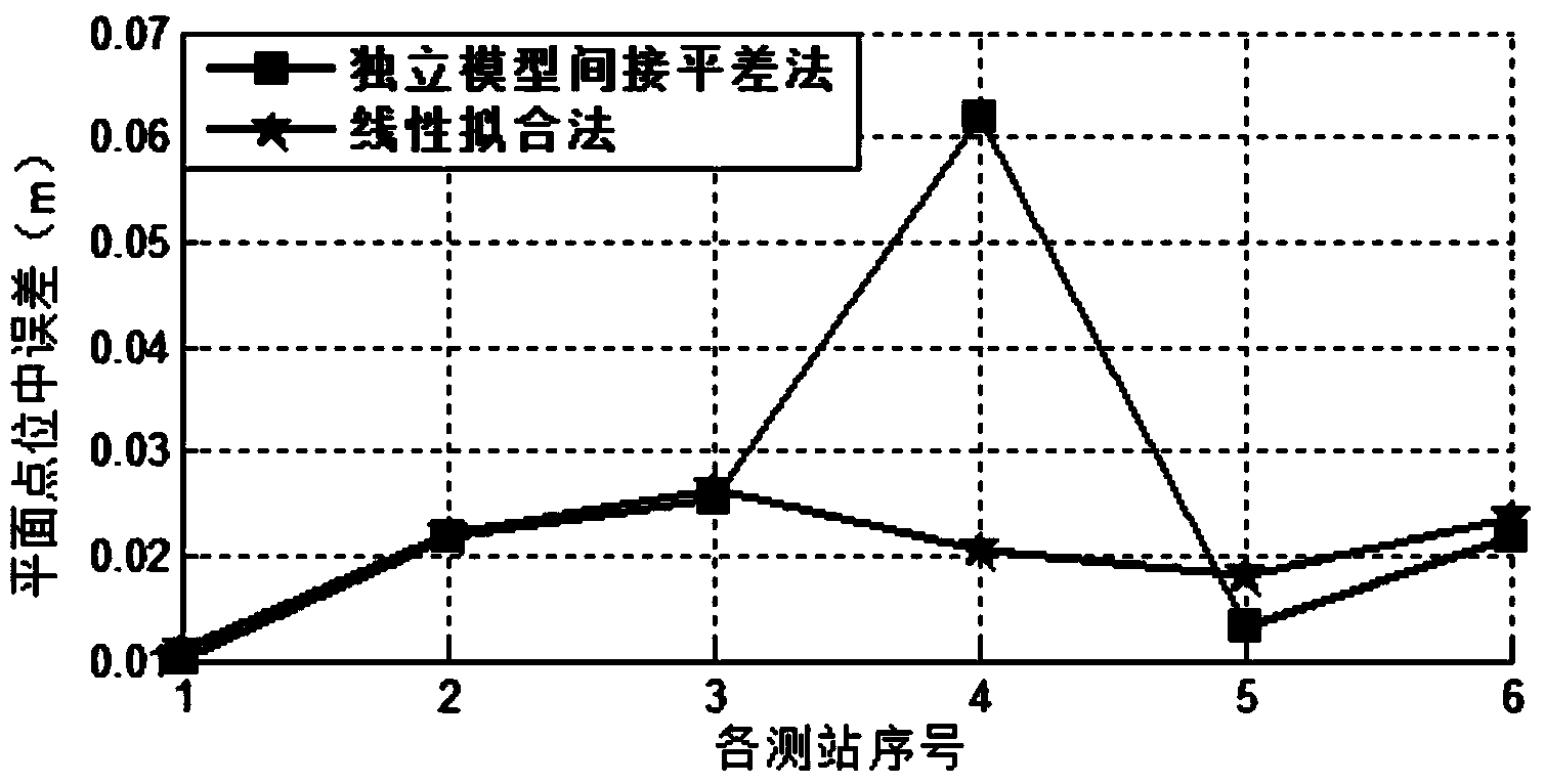
[0059] Attached below Figure 1~4 The present invention is further described. With Riegl VZ-1000, 4-5 spherical directional targets are arranged at each scanning station, and there are 2-3 spherical public targets at adjacent scanning stations. The experimental process adopts the coordinate system of 80 Xi'an coordinate system, with Gaussian east coordinate as X, Gaussian north coordinate as Y, and 85 elevation as Z, forming an approximate right-handed three-dimensional rectangular coordinate system. The spherical target is mounted on a centerable level base. A total of 6 stations were scanned, each station has about 40 million scanning points, and a total of spherical markers were arranged.

[0060] There are 15 targets, of which 8 are single targets, 2 are 2-fold targets, 4 are 3-fold targets, and 1 is 4-fold targets. Data processing uses the point cloud processing software developed by IDL language, using the function of "block network adjustment method" and "independent...


PUM


Abstract

The invention relates to an integral orientation method of ground scanning point cloud through linear fitting. The method is characterized by comprising the following steps: (1) distributing a spherical orientation target in a measured regional network for multistation scanning to obtain scanning point cloud data; (2) connecting into lines from all scanning stations to the spherical orientation target observed on the scanning stations to form the regional network; (3) carrying out fitting on coordinates of the sphere center of the spherical orientation target in a scanner coordinate system; (4) collating run adjustment; (5) setting up a mathematical model of a single laser beam, deducing a linear fitting mathematical model of the laser beam with the same name, estimating the error in point measurement of point cloud orientation, and transforming point cloud coordinates into a coordinate system designated by engineering surveying, thereby achieving integral orientation of point cloud. According to the method, the parameter approximate value is not required to be calculated, solution parameters can be directly fitted, the formula is simple, and the more the scanning stations are, the higher the resolving precision is.

Description

technical field [0001] The invention provides a linear fitting ground scanning point cloud overall orientation method, which belongs to the field of engineering measurement. Background technique [0002] The scanning speed of ground 3D laser scanners is getting faster and faster, from 5,000 points per second in the early stage to 1 million points per second, and the number of stations scanned in the field can reach 50 stations or even hundreds of stations every day. It becomes a key technology to convert the point cloud in the coordinate system to the measurement coordinate system specified by the project. The process of determining the position and attitude of the device in the engineering measurement coordinate system during scanning is called point cloud orientation, which is the process of determining the coordinate transformation parameters between the scanning device coordinate system and the engineering measurement coordinate system. Point cloud orientation is the ba...

Claims


Application Information

Patent Timeline
Patent Type & Authority Applications(China)
IPC IPC(8): G01C7/02G01B11/24
CPCG01B11/24G01C7/02
Inventor 张大富姚吉利刘科利马宁贾象阳徐广鹏李彩林郭宝云
Owner SHANDONG UNIV OF TECH
Why Eureka
Try Eureka