Imaging satellite autonomous mission planning algorithm based on receding horizon control

A technology for autonomous missions and imaging satellites, applied in computing, special data processing applications, instruments, etc., to achieve the effect of good planning results, optimality and real-time integration

Inactive Publication Date: 2014-09-24
NAT UNIV OF DEFENSE TECH
View PDF2 Cites 27 Cited by
  • Summary
  • Abstract
  • Description
  • Claims
  • Application Information

AI Technical Summary

Problems solved by technology

Imaging satellites adjust the observation plan in real time according to the observation tasks that may appear at any time in the interactive information, and quickly respond to various emergencies or gradual events through collaborative observation of satellites in the network, thus pr

Method used


Image

  • Imaging satellite autonomous mission planning algorithm based on receding horizon control
  • Imaging satellite autonomous mission planning algorithm based on receding horizon control
  • Imaging satellite autonomous mission planning algorithm based on receding horizon control

Examples


Embodiment Construction

[0050] 1. Problem description:

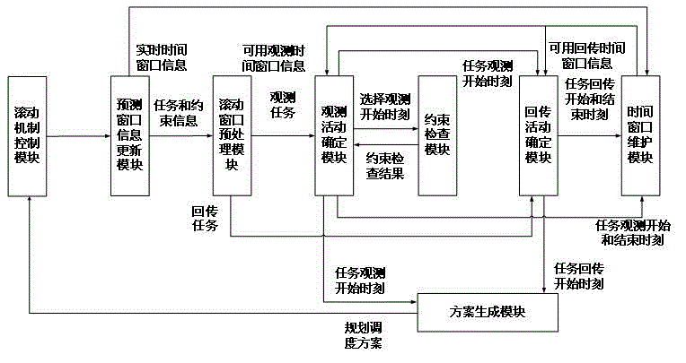
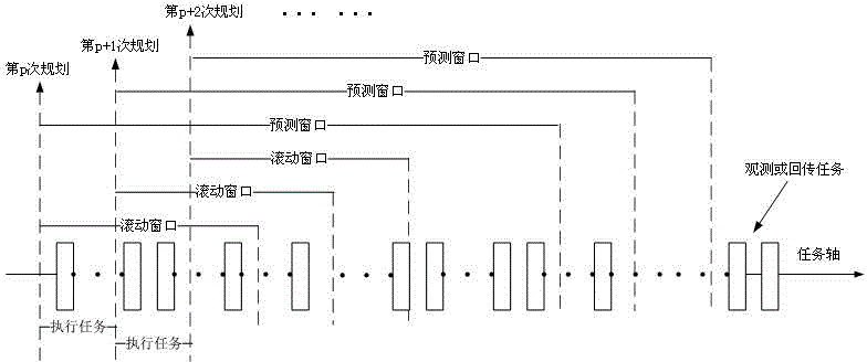
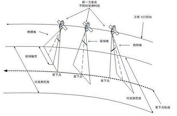
[0051] When imaging satellites observe the earth, they not only have to follow various strict constraints, but also can only observe the targets within their observation area. The observation area of ​​the imaging satellite is jointly determined by the sub-satellite point, the roll angle, the pitch angle and the field of view angle, such as image 3 shown. During the planning period, imaging satellites may have multiple opportunities to observe an observation target, but each orbit has at most one opportunity to observe the target, and each observation task has certain observation benefits. Therefore, the problem of autonomous mission planning for imaging satellites can be described as, imaging satellites can generate mission planning schemes autonomously on the satellite according to their own state, external environment and other constraints in real time without ground intervention. Plan time and resource consumption to obtain the maximum p...


PUM


Abstract

The invention relates to an imaging satellite autonomous mission planning algorithm based on receding horizon control. According to the invention, research is conducted for the imaging satellite autonomous mission planning problem, an autonomous mission planning frame based on the RHC strategy is established, the optimization method of the rolling construction mission planning subproblem is described, and an imaging satellite autonomous mission planning heuristic algorithm based on the RHC strategy is provided. In the experimental analysis, through the contrast experiment of different problem scales and different RHC strategy parameters, the RHC-based heuristic algorithm provided in the invention is verified to be effective for the imaging satellite autonomous mission planning problem, the planning while executing strategy of the algorithm has the advantage of good robustness for dynamic missions that may occur in an earth observation network at any time, so the contradiction between the real-time performance and the optimality in the imaging satellite autonomous mission planning problem can be well solved.

Description

technical field [0001] The invention relates to an imaging satellite autonomous mission planning algorithm based on rolling time domain control. Background technique [0002] In recent years, with the continuous development of satellite remote sensing technology, the earth observation network has gradually become a research hotspot at home and abroad. The earth observation network is composed of various imaging satellites, relying on event perception to trigger inter-satellite or satellite-ground information interaction. Imaging satellites adjust the observation plan in real time according to the observation tasks that may appear at any time in the interactive information, and quickly respond to various emergencies or gradual events through collaborative observation of satellites in the network, thus providing multi-source data with multiple spatial, temporal and spectral resolutions. While remote sensing data is of great significance to promoting national military, economi...

Claims


Application Information

Patent Timeline
IPC IPC(8): G06Q10/04G06F17/50
Inventor 邢立宁刘嵩袁驵贺仁杰姚锋杨振宇刘晓路王沛张雪婷义余江李星朱剑冰郭坚汪路元
Owner NAT UNIV OF DEFENSE TECH
Why Eureka
Try Eureka