Unmanned aerial vehicle remote-sensing image building three-dimensional damage detection method
A detection method and building technology, applied in 3D modeling, image data processing, instruments, etc., can solve the problems of difficult detection of building height change information, difficulty in extracting building height change information, and lack of universal applicability
- Summary
- Abstract
- Description
- Claims
- Application Information
AI Technical Summary
Problems solved by technology
Method used
Image
Examples
Embodiment Construction
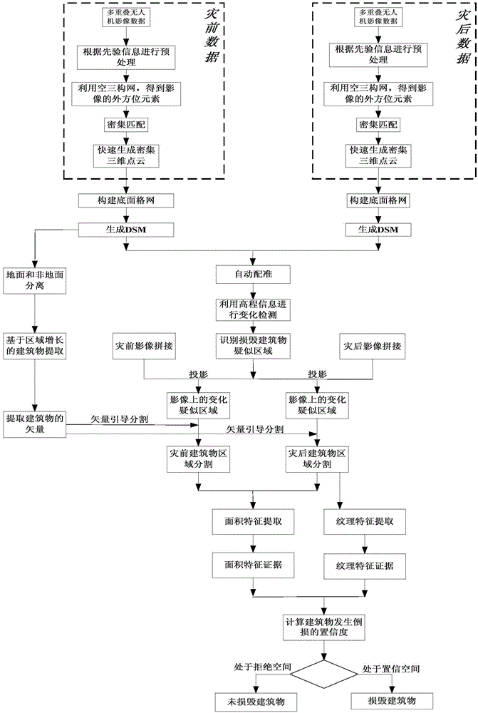
[0033] The invention provides a method for detecting building damage changes based on three-dimensional, which generates three-dimensional point clouds through overlapping drone aerial images, uses pre-disaster three-dimensional point cloud information to extract building vector information, and utilizes pre-disaster and post-disaster building The elevation, area and texture of objects are compared for change detection, and finally the damaged buildings are obtained. The technical solution of the present invention can adopt computer software technology to realize the automatic operation process. The technical solution of the present invention will be described in detail below in conjunction with the drawings and embodiments.
[0034] like figure 1 , the embodiment includes the following steps:
[0035] Step 1: Process the pre-disaster data and post-disaster data separately.
[0036] Embodiment Based on the multi-overlapping UAV remote sensing images of pre-disaster data and...
PUM
 Abstract
Description
Claims
Application Information
 - R&D
- Intellectual Property
- Life Sciences
- Materials
- Tech Scout
- Unparalleled Data Quality
- Higher Quality Content
- 60% Fewer Hallucinations
Browse by: Latest US Patents, China's latest patents, Technical Efficacy Thesaurus, Application Domain, Technology Topic, Popular Technical Reports.
© 2025 PatSnap. All rights reserved.Legal|Privacy policy|Modern Slavery Act Transparency Statement|Sitemap|About US| Contact US: help@patsnap.com


