Plane exploration method based on panoramic image depth map

A panoramic image and depth map technology, applied in the field of surface detection based on panoramic image depth map, can solve problems such as large-scale data production that is not suitable for automation, low accuracy, and failure to solve facade detection

Active Publication Date: 2014-11-19
CHONGQING CYBERCITY SCI TECH +1
View PDF4 Cites 5 Cited by
  • Summary
  • Abstract
  • Description
  • Claims
  • Application Information

AI Technical Summary

Problems solved by technology

[0006] 1) The ground is detected by the horizontal ground intersection method. In the case of up and down slopes, the accuracy is not high, and the detection of the facad

Method used


Image

  • Plane exploration method based on panoramic image depth map
  • Plane exploration method based on panoramic image depth map
  • Plane exploration method based on panoramic image depth map

Examples


Embodiment Construction

[0042] Below in conjunction with accompanying drawing and embodiment the present invention will be further described:

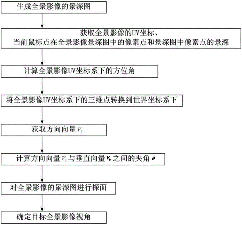
[0043] Such as figure 1 As shown in , a surface detection method based on the panoramic image depth map includes the following steps:

[0044] Step 1: Generate a depth map of the panoramic image.

[0045] Step 2, obtain the UV coordinates (u, v) of the current mouse point in the panoramic image, and calculate the pixel point (I, J) of the current mouse point in the panoramic image depth map, I=v(λW-1), J =(1-u)(λH-1), W and H are the width and height of the panorama image, and λ is the ratio of the width of the depth map to the width of the panorama; then obtain the pixel points (I, J ) depth of field L.

[0046] Step 3, calculate the azimuth (α, β) of the three-dimensional coordinate point p (x, y, z) in the panoramic coordinate system corresponding to the (I, J) pixel in the panoramic coordinate system, α=270-360u, β= 180v-90, α is the angle between the...


PUM


Abstract

The invention discloses a plane exploration method based on a panoramic image depth map, belonging to the field of measurable street view images. According to the method, the ground exploration plane of a depth map is used, thus uphill and downhill road section detection results are more accurate, at the same time, since the depth map is automatically produced by using point cloud, the degree of automation is high, the manual intervention is not needed, and the data production cost is low. For a building facade area plane exploration result, a target panorama is selected according to the principle of maximum perspective, and the method is more in accordance with the actual situation.

Description

technical field [0001] The invention belongs to the field of measurable street view images, in particular to a surface detection method based on a panoramic image depth map. Background technique [0002] Panoramic images are also called street views or street view images. At present, the street view services provided by Tencent Street View and Baidu Street View have been widely recognized. [0003] Find the laser point cloud within the corresponding range according to the center coordinates of the panoramic image, project it into the panoramic image according to the requirements of spherical projection, and calculate the distance from the panoramic center point to each point cloud, and assign the distance value to the pixel point in the panoramic image That is, the depth of field information, to obtain the panoramic depth of field map. [0004] During the mouse movement, it is necessary to display the results of ground and building surveys in real time, and then perform pan...

Claims


Application Information

Patent Timeline
IPC IPC(8): G06T7/00
Inventor 向泽君吕楠明镜徐占华罗再谦龙川张婕殷飞陈汉杨元饶鸣梁建国滕德贵刘颖郑良黄志胡小林
Owner CHONGQING CYBERCITY SCI TECH
Why Eureka
Try Eureka