
Road congestion optimization algorithm based on grid theory

A grid and road technology, applied in the field of optimization algorithms, can solve high complexity and other problems, achieve the effect of improving efficiency, efficient and fast calculation methods, and avoiding map vector calculations

Inactive Publication Date: 2015-01-28
HEFEI XINGFU INFORMATION TECH
View PDF7 Cites 16 Cited by
  • Summary
  • Abstract
  • Description
  • Claims
  • Application Information

AI Technical Summary

Problems solved by technology

[0005] The common feature of these patented methods is to extract road vehicle data, conduct data analysis, convert into traffic index or fit to traffic state model, which has high complexity

Method used


Image

  • Road congestion optimization algorithm based on grid theory
  • Road congestion optimization algorithm based on grid theory
  • Road congestion optimization algorithm based on grid theory

Examples


Embodiment Construction

[0018] The gridded congestion algorithm of the present invention is mainly used to improve the calculation efficiency of road congestion, especially for large and medium-sized cities with high real-time requirements for congestion.

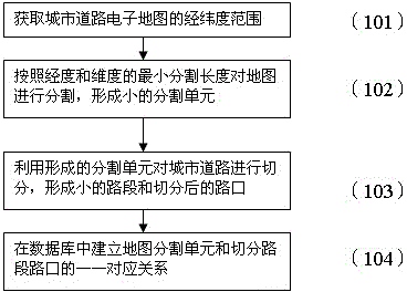
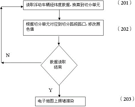
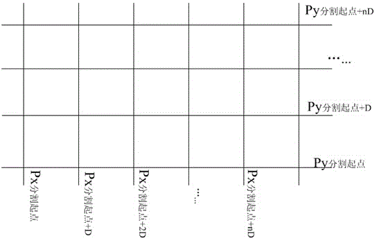
[0019] In order to realize this grid processing optimization method, it is first necessary to grid the urban area, the starting point and interval value of the grid should be fixed, and then divide the road according to the grid and establish the corresponding relationship between the grid and the intersection of the road section. Both are initial preparations, only need to be prepared once and saved to the database, such as figure 1 shown. Finally, according to the real-time floating vehicle position data, combined with the grid starting point value and interval value, the grid unit to which the position belongs is obtained, and thus belongs to the corresponding road section or intersection. When the data reading is completed, the congestion cal...


PUM


Abstract

The invention provides a road congestion optimization algorithm based on the grid theory and relates to an optimization algorithm for congestion algorithm by positioning floating vehicle data in city road grids. The method is characterized in that city regions are divided into grids, city roads are partitioned into thin segments through the grids and are located in the corresponded grids, and the correspondences between the grids and roads are established; the floating vehicle data are classified according to the grids where the floating vehicle data belong to, the number of vehicles of each grid corresponds to the corresponded segments, and the road congestion algorithm is acquired.

Description

technical field [0001] The invention proposes an optimization algorithm for road congestion analysis using the grid principle, which is especially suitable for the congestion analysis of urban road intersections. Background technique [0002] At present, there are already various road congestion algorithms in the prior art. [0003] For example, the traffic index algorithm: it is obtained by in-depth processing of the dynamic vehicle location information (floating vehicle data for short) distributed in the streets and alleys of the city, and the dynamic data is sent back to the data processing center through the vehicle-mounted GPS on the taxis in the city. Firstly, the vehicle position data is processed to obtain the running speed of roads with different functional levels, and then the weight of the road in the whole network is calculated according to the different road functions and traffic data, and finally converted to 0-10 based on people's perception and judgment of co...

Claims


Application Information

Patent Timeline
IPC IPC(8): G06F9/44G08G1/01
Inventor 胡平
Owner HEFEI XINGFU INFORMATION TECH
Learn More