Navigation method, device and system for general aviation aircraft

A technology of general aviation and navigation methods, applied in the field of general aviation, can solve problems such as poor flight safety, and achieve the effects of strong versatility, avoiding flight accidents, and avoiding potential safety hazards

Active Publication Date: 2015-03-11
BEIJING KEHANG JUNWEI TECH
View PDF4 Cites 25 Cited by
  • Summary
  • Abstract
  • Description
  • Claims
  • Application Information

AI Technical Summary

Problems solved by technology

[0014] The main purpose of the present invention is to provide a navigation method, device and system for general aviation aircraft, to solve the problem of poor flight safety of low-altitude and ultra-low-altitude general aircraft in the prior art

Method used


Image

  • Navigation method, device and system for general aviation aircraft
  • Navigation method, device and system for general aviation aircraft
  • Navigation method, device and system for general aviation aircraft

Examples


Embodiment 1

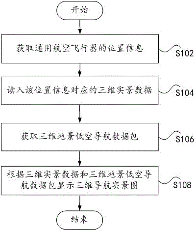
[0048] figure 2 It is a flowchart of a navigation method for a general aviation aircraft according to Embodiment 1 of the present invention. The navigation method can be applied to a navigator installed on a general aviation aircraft, thereby assisting a pilot to fly in a WYSIWYG manner. Specifically, as figure 2 As shown, the method includes the following steps S102 to S108.

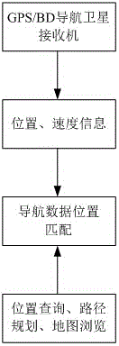
[0049] Step S102: Obtain the location information of the general aviation aircraft.

[0050] Step S104: Read in the 3D real scene data corresponding to the location information.

[0051] Step S106: Obtain a 3D landscape low-altitude navigation data package, wherein the 3D landscape low-altitude navigation data package includes basic data, low-altitude obstacle data, threat area data, and security area data.

[0052] Step S108: Displaying a 3D navigation real scene map according to the 3D real scene data and the 3D landscape low-altitude navigation data package.

[0053] When the navigator adopts ...

Embodiment 2

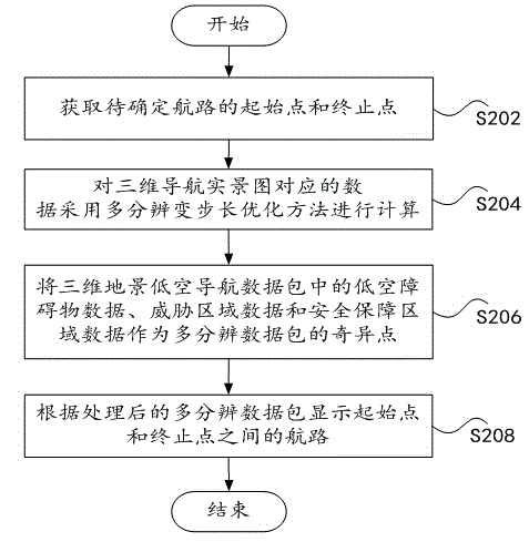
[0067] image 3 It is a flowchart of a navigation method for a general aviation aircraft according to Embodiment 2 of the present invention. This example is in figure 2 An embodiment of a navigation method further improved on the basis of the navigation method shown, by figure 2 In the shown embodiment, the three-dimensional navigation real scene map can be displayed in the navigator, through image 3 In the illustrated embodiment, the flight route can be further determined according to the starting point and the ending point of the flight. It should be noted that, to avoid redundant description, only the improved part is described in detail here. Specifically, as image 3 As shown, the method includes the following steps S202 to S208 while displaying the three-dimensional navigation real scene map.

[0068] Step S202: Obtain the start point and end point of the route to be determined.

[0069] Step S204: Calculate the data corresponding to the three-dimensional naviga...

Embodiment 3

[0083] According to another aspect of the present invention, a navigation device for a general aviation aircraft is provided. The navigation device is used to execute any navigation method for general aviation aircraft provided by the present invention.

[0084] Figure 6 It is a block diagram of a navigation device for a general aviation aircraft according to Embodiment 3 of the present invention. The navigation device can be applied to a navigator installed on a general aviation aircraft, thereby assisting a pilot to fly in a WYSIWYG manner. Specifically, as Figure 6 As shown, this example is compatible with figure 2 Corresponding to the illustrated embodiment, the device includes a first acquisition module 10 , a read-in module 30 , a second acquisition module 50 , and a display module 70 .

[0085] Wherein, the first acquisition module 10 is used to acquire the position information of the general aviation aircraft, and the acquisition module can receive satellite sig...


PUM


Abstract

The invention discloses a navigation method, device and system for a general aviation aircraft. The navigation method for the general aviation aircraft comprises steps as follows: location information of the general aviation aircraft is acquired; three-dimensional realistic scene data corresponding to the position information are read; a three-dimensional landscape low-altitude navigation data package is acquired and comprises basic data, low-altitude barrier data, threatening area data and safety guarantee area data; and a three-dimensional navigation realistic picture is displayed according to the three-dimensional realistic scene data and the three-dimensional landscape low-altitude navigation data package. By means of the method, the device and the system, flying safety of the general aviation aircraft in low altitude and super-low altitude can be effectively improved.

Description

technical field [0001] The present invention relates to the technical field of general aviation, in particular to a navigation method, device and system for general aviation aircraft. Background technique [0002] With the gradual opening of low-altitude airspace, general aviation will be greatly developed. However, the safety of low-altitude and ultra-low-altitude flights is not optimistic. The reasons are not only low flying altitude, difficult tracking and monitoring, complex environmental conditions, and short time to deal with dangers. The flight safety environment of low-altitude and ultra-low-altitude general aviation aircraft is also deteriorating, and factors endangering safety are increasing, as follows: [0003] (1) The clearance environment deteriorates. The urbanization process is accelerating, and the existing airport has been surrounded by residential areas and emerging development areas. The clearance conditions of the airport are gradually deteriorating. Wh...

Claims


Application Information

Patent Timeline
Patent Type & Authority Applications(China)
IPC IPC(8): G01C21/00
CPCG01C21/00
Inventor 郭汉伟陈贵棠
Owner BEIJING KEHANG JUNWEI TECH
Why Eureka
Try Eureka