A rapid generation method of real-time environmental monitoring thematic pictures based on user location

An environmental monitoring and picture technology, applied in special data processing applications, instruments, electrical and digital data processing, etc., can solve problems such as difficult for users to understand the real environmental quality, and achieve the effect of reducing computing load

Active Publication Date: 2018-08-14
COMP NETWORK INFORMATION CENT CHINESE ACADEMY OF SCI
View PDF6 Cites 0 Cited by
  • Summary
  • Abstract
  • Description
  • Claims
  • Application Information

AI Technical Summary

Problems solved by technology

[0004] Under existing technical conditions, location-based real-time environmental quality monitoring services, such as air pollution indicators, temperature, precipitation, etc., only provide users with the actual or simulated values ​​monitored at spatial coordinate points, or the overall average value of the area. It is not easy for users to understand the real environmental quality around the current geographic location by presenting it in the form of numerical values.

Method used


Image

  • A rapid generation method of real-time environmental monitoring thematic pictures based on user location

Examples


Embodiment Construction

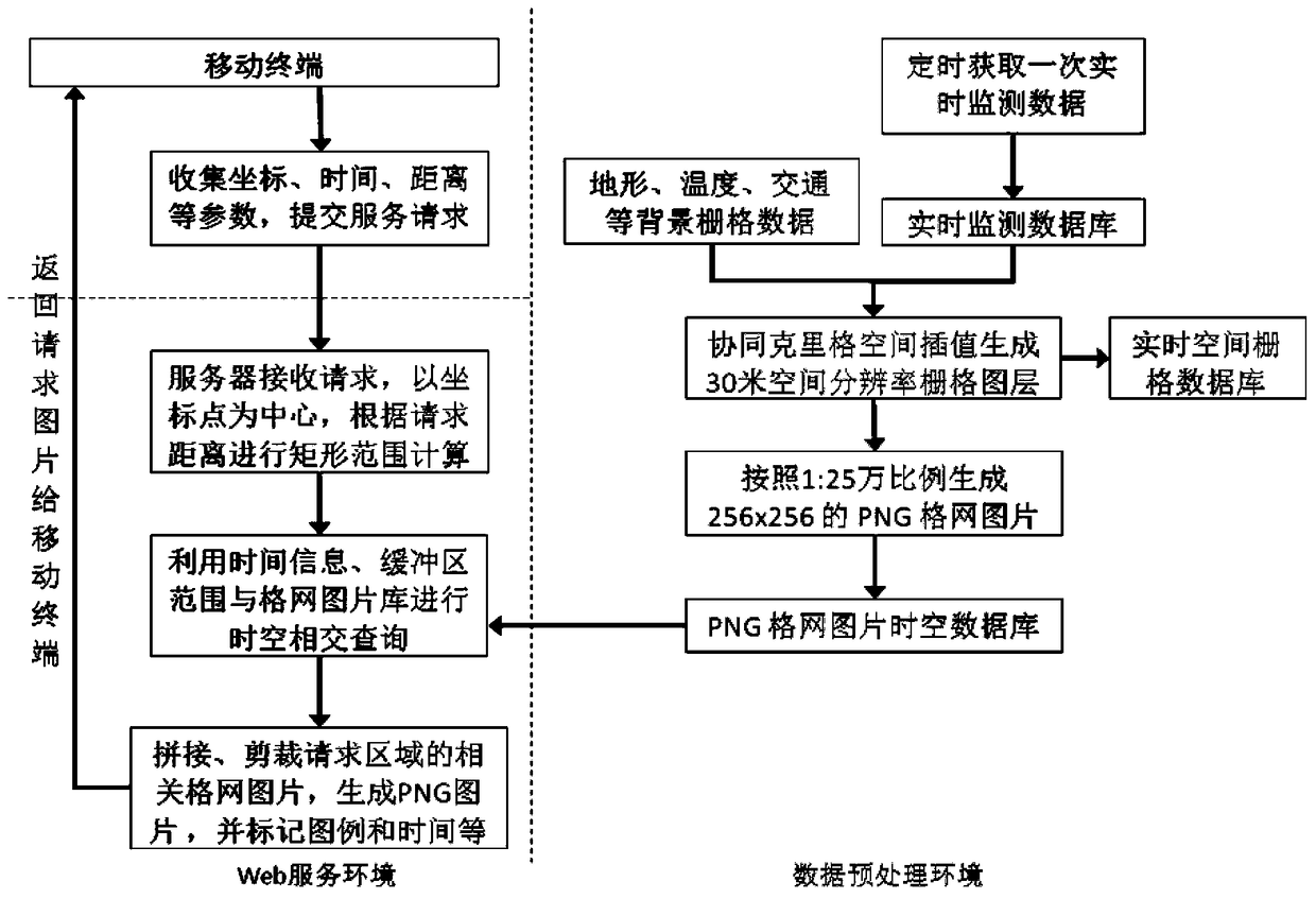
[0018] The present invention involves two data service environments: a data preprocessing environment and a WEB service environment, wherein the data preprocessing environment realizes: real-time monitoring data timing acquisition and storage, real-time monitoring data space interpolation, real-time monitoring grid data grid image generation , real-time monitoring of steps such as space-time storage of data grid pictures; WEB service environment is responsible for receiving client service requests, parsing request parameters for rectangular range calculation, real-time monitoring of data grid picture space-time intersecting retrieval, picture splicing and clipping and other functions.

[0019] Below in conjunction with accompanying drawing and air pollutant data, the present invention is described in further detail as an example:

[0020] Data Preprocessing Environment

[0021] The first step, real-time monitoring data timing acquisition and storage: use Python language to wri...


PUM


Abstract

The invention discloses a method for rapidly generating a real-time environment monitoring special topic picture based on a user location. The method comprises the following steps: (1) a server performs spatial interpolation on environment monitoring data to obtain a raster map layer, and generates a PNG (Portable Network Graphic) grid picture according to the raster map layer; (2) a client sends an environment inquiry request, and the server generates a rectangular coordinate range of a request region according to the request; (3) the server inquires all PNG grid pictures of the request region from a grid picture database according to time information in the request, the type of the special topic picture and the rectangular coordinate range, performs splicing, cuts by using the rectangular range to obtain an environment monitoring special topic picture, and returns the environment monitoring special topic picture to the client for displaying. By adopting the method, a user can conveniently and rapidly know a surrounding environmental condition from a space-time location.

Description

technical field [0001] The present invention provides real-time environmental monitoring data thematic picture rapid generation technology based on user location information, and specifically relates to a method of providing users with environmental quality monitoring within a certain area around their current location in the form of visualized pictures based on the location information of the user's mobile terminal Method for thematic map information. Background technique [0002] Environmental problems are becoming more and more serious, especially air pollution and noise pollution in cities, which have become one of the most serious environmental problems and are directly related to people's health. Making the public obtain environment-related information will not only help the public understand the environmental conditions they live in, but also help improve their environmental awareness. And because people have innate spatial vision capabilities, maps have become the m...

Claims


Application Information

Patent Timeline
Patent Type & Authority Patents(China)
IPC IPC(8): G06F17/30
CPCG06F16/5866
Inventor 王学志赵江华黎建辉周园春
Owner COMP NETWORK INFORMATION CENT CHINESE ACADEMY OF SCI
Why Eureka
Try Eureka