
Space information network system based on low-earth-orbit satellite constellation

A space information network and low-orbit constellation technology, applied in the transmission system, network topology, radio transmission system, etc., can solve the problems of poor invulnerability of networking methods, low transmission efficiency, poor system invulnerability, etc., and achieve flexible business adaptation performance, high network efficiency, and good invulnerability

Inactive Publication Date: 2015-03-25
SHANGHAI SATELLITE ENG INST
View PDF4 Cites 11 Cited by
  • Summary
  • Abstract
  • Description
  • Claims
  • Application Information

AI Technical Summary

Problems solved by technology

[0004] The existing spatial information network system and its networking methods are more common in the mixed networking mode of high, medium and low, including GEO / MEO, MEO / LEO double-layer satellite network, and GEO / MEO / LEO three-layer network. The network system and its networking method make full use of the characteristics of satellite spatial location distribution, and adopt an approximate tree-like network structure, which is easier to manage centrally, but the system has poor invulnerability. Once a high-level node fails, the network nodes in its coverage area will follow not working
In addition, the biggest disadvantage of the system is that the delay is too large, and any service will pass through a higher-level node, which means a longer distance transmission delay
The spatial information network system composed of GEO satellites, MEO satellites or LEO satellites has also been studied correspondingly, but its networking method also has problems such as poor invulnerability, long delay, or low transmission efficiency.

Method used


Image

  • Space information network system based on low-earth-orbit satellite constellation

Examples


Embodiment Construction

[0023] The method provided by the present invention will be further described in detail below with reference to the drawings and specific embodiments.

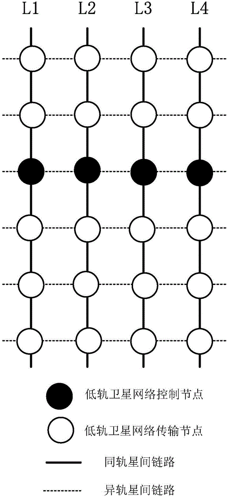
[0024] figure 1 In the illustrated embodiment of the present invention, the number of low-orbit satellite control nodes M is defined as 4, the number of low-orbit satellite transmission nodes N is defined as 20, the number P of inter-satellite links in the same orbit is defined as 24, and the number of inter-satellite links in different orbits is defined as 24. The quantity Q is defined as 24.

[0025] System components include:

[0026] 4 low-orbit satellite control nodes, 20 low-orbit satellite transmission nodes, 24 same-orbit inter-satellite links and 24 different-orbit inter-satellite links.

[0027] The 4 low-orbit satellite control nodes are distributed on 4 orbital planes L1, L2, L3, and L4, which are undertaken by satellites running near the equator, responsible for network view collection, formulation, calculation and distr...


PUM


Abstract

The invention discloses a space information network system based on a low-earth-orbit satellite constellation. The space information network system comprises M low-earth-orbit satellite control nodes, N low-earth-orbit satellite transmission nodes, P common-orbit-plane inter-satellite links and Q different-orbit-plane inter-satellite links. The M low-earth-orbit satellite control nodes are distributed on M orbit planes and borne by satellites close to the equator and are responsible for collection of network views and making, calculation and issuing of space data forwarding rules. The N low-earth-orbit satellite transmission nodes are evenly distributed on the M orbit planes, the low-earth-orbit satellite transmission nodes in the same orbit plane are controlled by the low-earth-orbit satellite control nodes in the same orbit plane, and the N low-earth-orbit satellite transmission nodes exchange, distribute and transmit space data according to received distribution rules. The P common-orbit-plane inter-satellite links provide physical channels for data transmission between stars in the same orbit plane. The Q different-orbit-plane inter-satellite links provide physical channels for data transmission between stars in different orbit planes. Compared with a traditional space information network, the low-earth-orbit satellite network system has better survivability, shorter time delay, higher network efficiency and more flexible service adaptability.

Description

Technical field [0001] The invention relates to satellites and network systems in the field of aerospace technology, and in particular to a space information network system including a low-orbit satellite control node and a low-orbit satellite transmission node and a networking method thereof. Background technique [0002] The space information network system is a system built for the purpose of real-time acquisition, transmission, distribution and efficient application of various user spacecraft information in Skyrim. It is used by spacecraft as various network nodes, including comprehensive functions such as access, transmission, and control, and finally realizes end-to-end real-time transmission of space data. Spatial data includes load data, measurement and control data, data link data, and various instruction data. [0003] China currently has more than one hundred application satellites in orbit, but due to national territorial restrictions, most of the ground stations servi...

Claims


Application Information

Patent Timeline
IPC IPC(8): H04W84/06H04B7/185
CPCH04W84/06H04B7/18521
Inventor 陈荷
Owner SHANGHAI SATELLITE ENG INST
Learn More