Mobile sensor network clustering method based on geographical position information

A technology based on geographic location information and mobile sensors, applied in location-based services, network topology, wireless communication, etc., can solve problems such as unstable data forwarding, low data transmission efficiency, and poor network scalability, and achieve energy consumption reduction, Ease of selection, long-life effects

Active Publication Date: 2015-04-01
NANJING UNIV OF POSTS & TELECOMM
View PDF5 Cites 25 Cited by
  • Summary
  • Abstract
  • Description
  • Claims
  • Application Information

AI Technical Summary

Problems solved by technology

[0006] The present invention solves the problems of low data transmission efficiency, poor network expansibility, high energy consumption and unstable data forwarding in traditional link state-based routing in large-scale mobile sensor networks

Method used


Image

  • Mobile sensor network clustering method based on geographical position information
  • Mobile sensor network clustering method based on geographical position information
  • Mobile sensor network clustering method based on geographical position information

Examples


Embodiment Construction

[0030] The present invention will be further described below in conjunction with the accompanying drawings and embodiments.
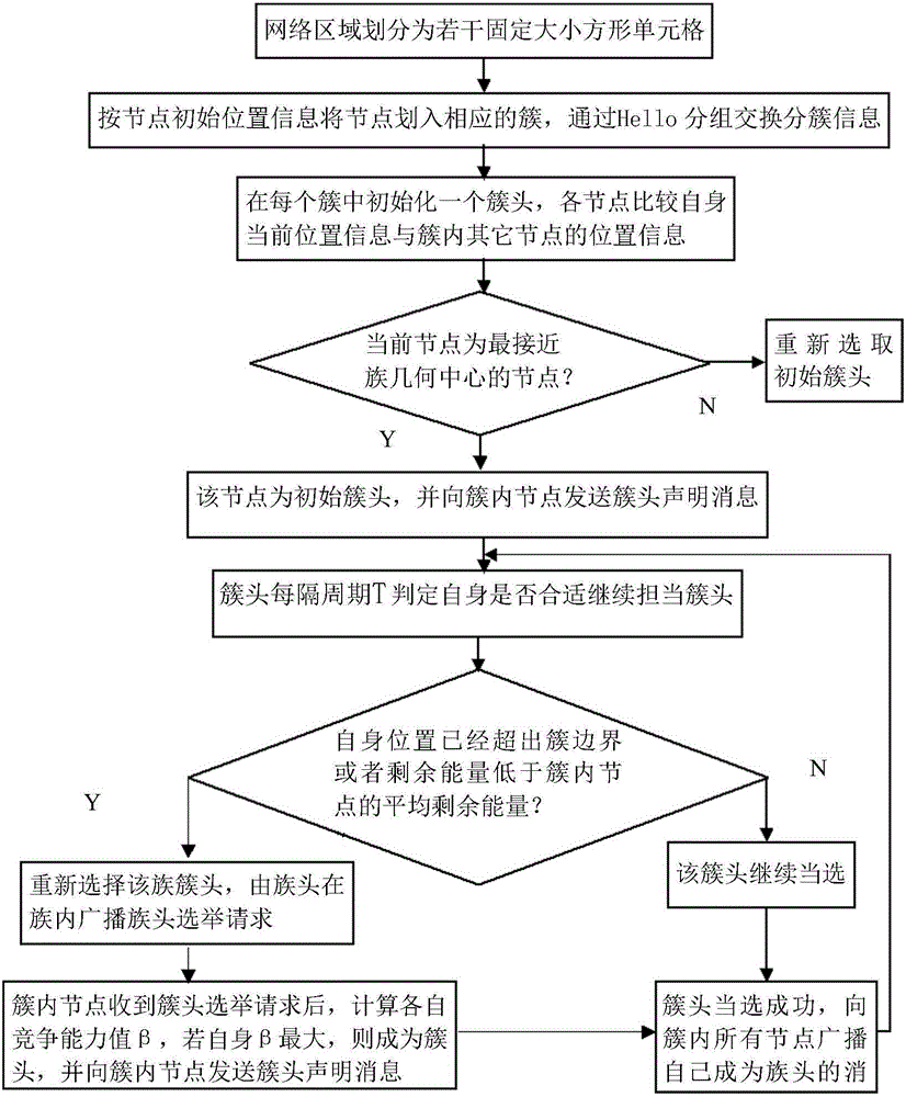
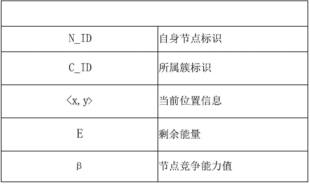
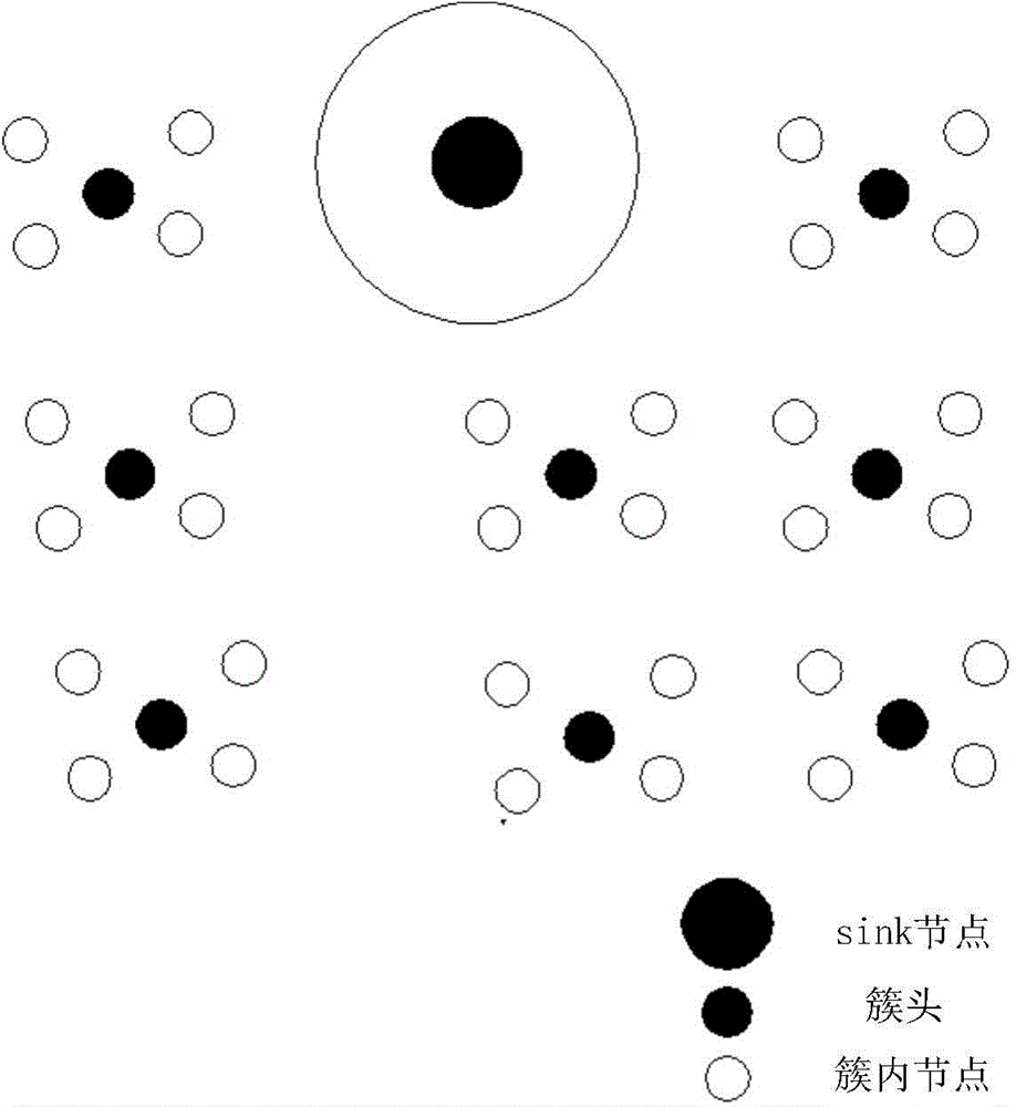
[0031] The design idea of ​​the present invention is: divide the network area into a number of fixed-sized square cells, each node knows the geometric center position and the cluster boundary of the cluster, divides the node into the corresponding cluster according to the initial position information of the node, and divides the node into the corresponding cluster through Hello packet exchange. Cluster information, the cluster information contained in the Hello packet is as follows figure 1 shown. A cluster head is initialized in each cluster, and each node compares its current position information with the position information of other nodes in the cluster. If it is the node closest to the geometric center of the cluster, the node is the initial cluster head and sends Cluster head declaration message. The cluster head judges whether it is suitable to...


PUM


Abstract

The invention provides a mobile sensor network clustering method based on geographical position information. According to the method, firstly, a network is divided into a plurality of cells, a cluster head is selected according to the distance from a node in a cluster to the geometrical center of the cells, and the whole network is initialized. If the rest energy of the current cluster head is lower than the average rest energy of the nodes in the cluster, or the condition that the current cluster head leaves away from the range of the current cluster is judged, the cluster head is triggered to be updated. The cluster head updating is carried out in a mode of combining the rest energy, the moving speed and the moving direction. The mobile sensor network clustering method has the characteristics that the cluster covering region division and the initial cluster head selection is simple and convenient; the data fusion is favorably realized, and the energy consumption is reduced; the cluster head is selected from the aspects of the energy consumption level and the mobility of the nodes, and the cluster structure and the cluster stability are enhanced; the special clustering control sub groups are not needed, and the control expenditure is reduced.

Description

technical field [0001] The invention belongs to the field of mobile sensor networks, and relates to a clustering method for mobile sensor networks based on geographic location information. Background technique [0002] In recent years, many studies have proposed schemes to collect data in mobile sensors. Using mobile sensor nodes in the network has many advantages compared to fixed sensor nodes. Mobility can reduce energy consumption, prolong the life of the network, and balance the load of the network. [0003] Among the routing protocols based on area division, there are mainly the following types: GAF (Geographical Adaptive Fidelity) protocol, TTDD protocol, GRID protocol, and GROUP protocol. The GAF protocol divides the network coverage area into multiple quadrilateral grids, and the nodes in the grid form a cluster, and the cluster head node is elected regularly, and other nodes are in a dormant state to save energy. The GAF protocol proposes an energy-saving strateg...

Claims


Application Information

Patent Timeline
Patent Type & Authority Applications(China)
IPC IPC(8): H04W4/00H04W4/02H04W84/18
CPCH04W4/00H04W4/021H04W4/026H04W4/027H04W84/18Y02D30/70
Inventor 徐佳黄永宁戴华徐小龙李千目王震王赓
Owner NANJING UNIV OF POSTS & TELECOMM
Why Eureka
Try Eureka