Navigation device, and navigation program product
A technology for navigation devices and roads, which is applied in directions such as navigation, measuring devices, mapping and navigation, and can solve problems such as insufficient information.
- Summary
- Abstract
- Description
- Claims
- Application Information
AI Technical Summary
Problems solved by technology
Method used
Image

Examples
no. 1 Embodiment approach
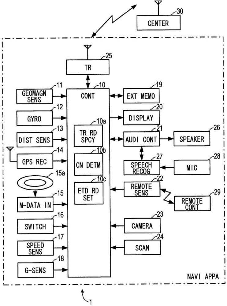
[0046] figure 1The illustrated navigation device (NAVI APPA) 1 is mounted on a vehicle, and is composed mainly of a control device (CONT) 10 . The control device 10 is configured as a so-called computer system, and has a central processing unit (Central Processing Unit (CPU)), a read only memory (Read Only Memory (ROM)), a random access memory (Random Access Memory (RAM)), an input / Output interface (Input / Output Interface (I / O)), and the bus connecting them.
[0047] A geomagnetic sensor (GEOMAGN SENS) 11, a gyroscope (GYRO) 12, a distance sensor (DIST SENS) 13, a GPS receiver (GPS REC) 14, and a map data input unit (M-DATA IN) 15 are connected to the control device 10 , Operation switch group (SWITCH) 16, speed sensor (SPEED SENS) 17, G sensor (acceleration sensor: G-SENS) 18, external memory (EXT MEMO) 19, display device (DISPLAY) 20, sound controller (AUDI CONT ) 21, remote sensing sensor (REMOTE SENS) 22, camera (CAMERA) 23, and scanner (SCAN) 24.
[0048] The geomagne...
no. 2 Embodiment approach
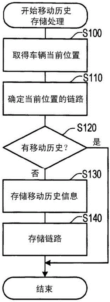
[0095] Next, according to Figure 7 and Figure 8 A navigation device 1 according to a second embodiment of the present invention will be described. In the second embodiment, the extended road setting process of the above-mentioned embodiment executed by the control device 10 is different. Therefore, according to Figure 7 and Figure 8 The extended road setting process executed by the control device 10 of this embodiment will be described. This extended road setting process is similar to the extended road setting process of the first embodiment, and is executed by the control device 10 at the timing when the IG switch is turned on. Of course, the processing execution timing is not limited to this. In addition, since there are processes added to the extended road setting process of the above-mentioned embodiment, the description will focus on these processes.
[0096]After acquiring the link in the first S200, the control device 10 acquires the road type, the road width,...
no. 3 Embodiment approach
[0111] Next, according to Figure 9 , Figure 11 to Figure 15 (b) The navigation device 1 according to the third embodiment of the present invention will be described. The navigation device 1 according to the present embodiment differs only in the switching of the map display on the display device 20 , so descriptions of the configuration and the like are omitted.
[0112] The control device 100 of the navigation control device 1 according to this embodiment includes a recognized road determination unit (RCG RD DETM) 100a, a recognized road determination unit (RCG RD SPCY) 100b, a switching unit (SW) 100c, and a notification unit (NOTIFY) 100e.
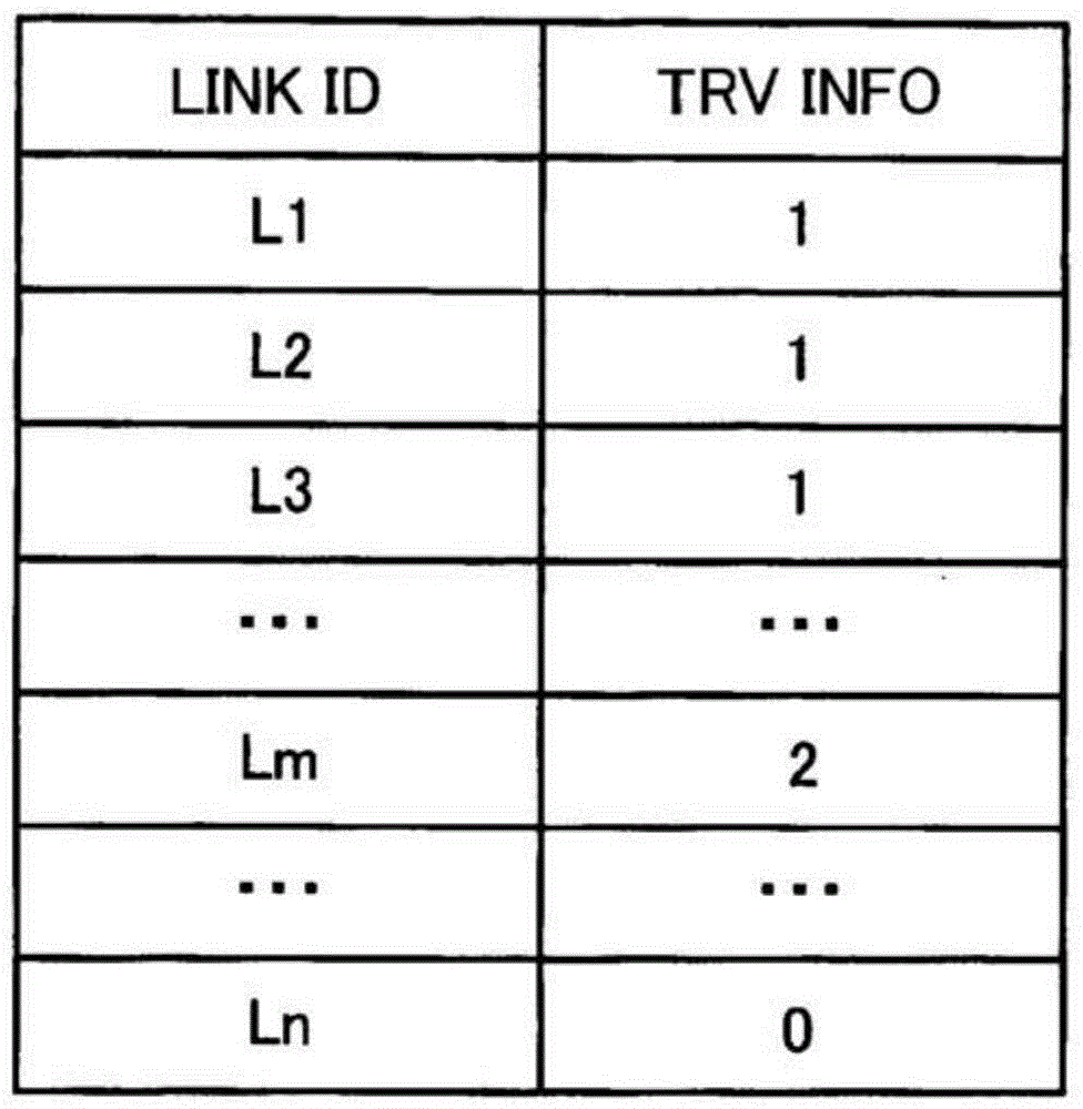
[0113] In the present embodiment, the "moving road" is a road that is actually traveled and the travel history information is set to "1", and the "extended road" is a road that extends from the travel road and the travel history information is set to "2". "Together they are called "knowing the road". In addition, the external memor...
PUM
 Abstract
Description
Claims
Application Information
 - R&D
- Intellectual Property
- Life Sciences
- Materials
- Tech Scout
- Unparalleled Data Quality
- Higher Quality Content
- 60% Fewer Hallucinations
Browse by: Latest US Patents, China's latest patents, Technical Efficacy Thesaurus, Application Domain, Technology Topic, Popular Technical Reports.
© 2025 PatSnap. All rights reserved.Legal|Privacy policy|Modern Slavery Act Transparency Statement|Sitemap|About US| Contact US: help@patsnap.com