
A high-precision command and dispatch system based on gps and lbs positioning capabilities

A command and dispatch system and GPS positioning technology, applied in the field of high-precision command and dispatch systems, can solve problems such as difficulty in vehicle dispatch, GPS positioning time-out, and inability to cover the entire area, so as to improve dispatch efficiency and execution efficiency and reduce equipment power consumption. Effect

Active Publication Date: 2018-04-27
ZHEJIANG RONGCHUANG INFORMATION IND
View PDF3 Cites 0 Cited by
  • Summary
  • Abstract
  • Description
  • Claims
  • Application Information

AI Technical Summary

Problems solved by technology

[0002] At present, due to the lack of necessary technical means, logistics companies generally have the following problems: it is difficult to dispatch vehicles, and because they cannot know the exact location of operating vehicles and their loading conditions, logistics companies cannot organize sources of goods and flexibly distribute goods for operating vehicles, and cannot Efficient scheduling and management of running vehicles
Due to the limitations of positioning technology itself, GPS positioning has an error within 30 meters, while LBS positioning has an error within 300 meters. Using the existing technology, it will inevitably be affected by the objective environment, resulting in a large gap between the position obtained by positioning and the actual position. Deviation
Regardless of simply using GPS positioning with higher accuracy or LBS positioning capabilities with a wider application range, there are situations where it cannot cover the entire area: in non-outdoor areas where satellite signals cannot be obtained, GPS will have positioning timeouts; and in low-density base stations In the wild, LBS may also locate overtime, or the deviation is huge
Only combining the two positioning capabilities according to priority can solve the problem of full area coverage to a large extent, but it cannot solve the problem of positioning accuracy
[0004] On the other hand, most of the current command and dispatch is to assign personnel to a location, and it is necessary to manually select personnel near the location, and then assign tasks
The shortest distance that can be distinguished by the naked eye is actually a straight line between two points, which is different from the "shortest path" in the sense of the map. Events at "close" locations violate the original intention of "scheduling nearby", and if the two dispatched locations are not far away, there will be overlaps in dispatched personnel, and manual dispatching alone may be inefficient, causing personnel to go Situation where another location is closer and ends up going to a location farther away

Method used


Image

  • A high-precision command and dispatch system based on gps and lbs positioning capabilities
  • A high-precision command and dispatch system based on gps and lbs positioning capabilities
  • A high-precision command and dispatch system based on gps and lbs positioning capabilities

Examples


Embodiment Construction

[0034] In order to describe the present invention more specifically, the technical solutions of the present invention will be described in detail below in conjunction with the accompanying drawings and specific embodiments.

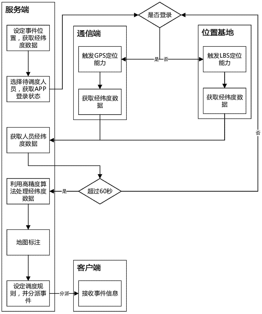
[0035] The system of the present invention is divided into four parts: a server, a communication terminal, a location base and a client. The server is used to initiate command and dispatch instructions, the communication terminal and location base are used to obtain terminal locations, and the client is used to receive command and dispatch information. The specific process of command and dispatch is as follows: figure 1 Shown:

[0036] The server sets the location of the event to be processed, and obtains the latitude and longitude parameters through the map mark;

[0037] The server selects the person to be dispatched and obtains the APP login status;

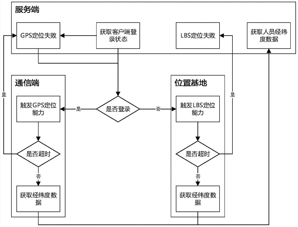
[0038] According to the login status, trigger the positioning capability of the communication termin...


PUM


Abstract

The invention discloses a high-precision command and dispatch system based on GPS and LBS positioning capabilities, which includes a server end, a communication end and multiple clients. The present invention utilizes the technology of combining GPS and LBS positioning capabilities to realize full terminal and full area coverage in the positioning area, and greatly reduces the power consumption of the equipment; at the same time, it adopts a high-precision algorithm to improve the accuracy of the latitude and longitude data from the algorithm level. To determine which set of cases is the most accurate, statistical principles are used to calculate the position as precise as possible. In addition, the present invention adopts the scheduling scheme of "shortest walking distance + nearest principle" to improve scheduling efficiency and execution efficiency, so as to truly respond to on-site events as soon as possible and resolve them as soon as possible.

Description

technical field [0001] The invention belongs to the technical field of logistics scheduling, and in particular relates to a high-precision command and scheduling system based on GPS and LBS positioning capabilities. Background technique [0002] At present, due to the lack of necessary technical means, logistics companies generally have the following problems: it is difficult to dispatch vehicles, and because they cannot know the exact location of operating vehicles and their loading conditions, logistics companies cannot organize sources of goods and flexibly distribute goods for operating vehicles, and cannot Efficient scheduling and management of running vehicles. During the transportation of the goods, the owner of the goods cannot keep abreast of the in-transit situation of the goods, lacks effective coordination and cooperation with the logistics company, and is also not conducive to the mutual trust between the owner and the logistics company. The empty load rate of ...

Claims


Application Information

Patent Timeline
Patent Type & Authority Patents(China)
IPC IPC(8): H04W4/02H04W64/00G01S19/42
CPCH04L67/12H04W4/02H04W52/02H04L67/52
Inventor 邓庆林宋逸徐孟强阮正林孙赟
Owner ZHEJIANG RONGCHUANG INFORMATION IND
Learn More