Seismic data prestack imaging method

An imaging method and seismic data technology, applied in the field of petroleum geological exploration seismic imaging, can solve the problems of difficult seismic data processing and accurate imaging of difficult seismic data, etc.

Inactive Publication Date: 2015-05-20
BEIJING RGL GEOLOGICAL SURVEY TECH CO LTD
View PDF2 Cites 9 Cited by
  • Summary
  • Abstract
  • Description
  • Claims
  • Application Information

AI Technical Summary

Problems solved by technology

Areas with complex surface and subsurface structures, such as deserts, mountains, piedmonts, loess plateaus, thrust zones in piedmont areas, exposed areas of carbonatite in the south, overthrust nappe structural belts, strong stratum folds, faults Abnormally complex and laterally heterogeneous areas that cause severe lateral velocity changes bring great difficulty to seismic data processing. Conventional seismic data processing methods and ideas are difficult to obtain accurate imaging results for seismic data in these areas

Method used


Image

  • Seismic data prestack imaging method
  • Seismic data prestack imaging method
  • Seismic data prestack imaging method

Examples


Embodiment Construction

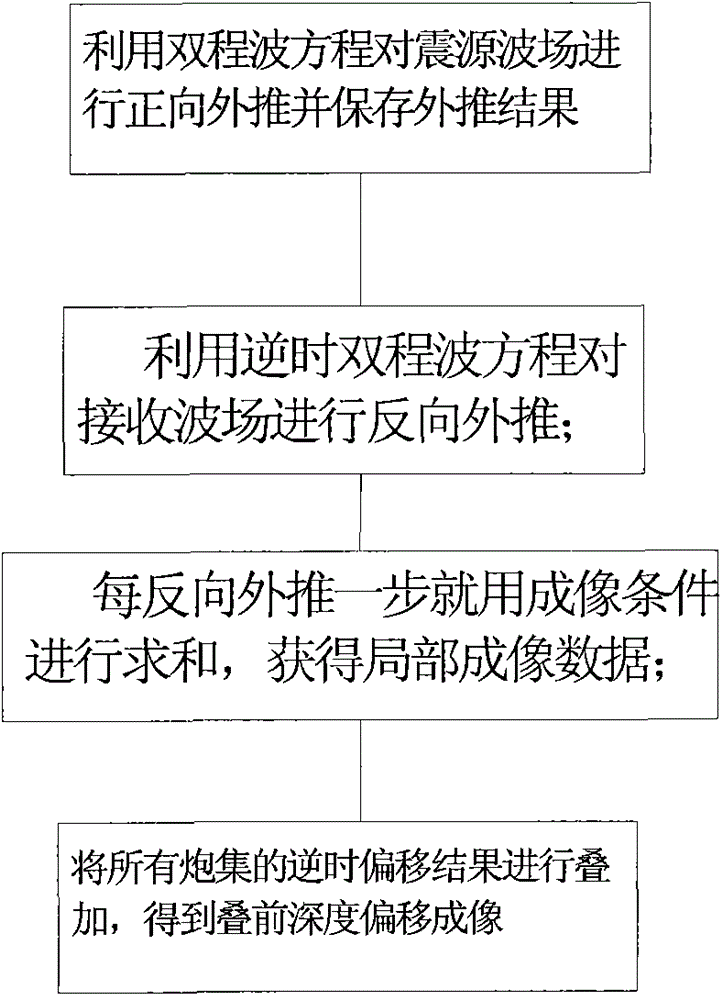
[0022] In order to improve the precision of seismic data imaging processing, an embodiment of the present invention provides a seismic data pre-stack imaging method. In the technical solution of the present invention, the source wave field is forwardly extrapolated by using the two-way wave equation. At the same time, The receiving wave field is reversely extrapolated by the reverse time two-way wave, and the reverse time migration results collected by the shot are superimposed to obtain the depth migration imaging before superimposition, thereby improving the accuracy of geological survey. In order to make the purpose, technical solution and advantages of the present invention clearer, the following examples are given to further describe the present invention in detail.

[0023] Such as figure 1 As shown, a method for pre-stack imaging of seismic data according to an embodiment of the present invention includes the following steps:

[0024] Use the two-way wave equation to p...


PUM


Abstract

The invention relates to a seismic data prestack imaging method. The method comprises the following steps: a two-way wave equation is used for carrying out forward extrapolation on a source wave field and storing an extrapolation result; a reverse-time two-way wave equation is used for carrying out backward extrapolation on a receiving wave field; imaging conditions are used for summation every one backward extrapolation step so as to acquire local imaging data; and all shot gather reverse-time migration results are stacked to acquire a prestack depth migration image. The seismic data prestack imaging method has the beneficial effects that the amplitude problem is solved; amplitude-preserving effects are good, no approximate amplitude and phase exit, and through precise lighting compensation and true amplitude imaging, lithology prediction becomes possible; the imaging precision problems are solved, steep dip imaging and turning wave imaging can be carried out, and the imaging effects are good; and the multiple wave imaging problems can be solved, such as convergence and focusing of multiple wave.

Description

technical field [0001] The invention relates to the field of petroleum geological exploration seismic imaging, in particular to a pre-stack imaging method for seismic data. Background technique [0002] With the continuous deepening of oil and gas exploration, the problems faced by seismic exploration have greatly increased. Whether it is complex surface or near-surface velocity vertical and horizontal changes in new and old exploration blocks, or underground complex structures, geophysicists have raised a lot of challenges. Challenging puzzles. Areas with complex surface and subsurface structures, such as deserts, mountains, piedmonts, loess plateaus, thrust zones in piedmont areas, exposed carbonatite areas in the south, overthrust nappe structural belts, strong stratum folds, faults Abnormally complex and laterally heterogeneous areas that cause severe lateral velocity changes bring great difficulty to seismic data processing. Conventional seismic data processing methods...

Claims


Application Information

Patent Timeline
Patent Type & Authority Applications(China)
IPC IPC(8): G01V1/28
Inventor 孙传文曲鸣飞
Owner BEIJING RGL GEOLOGICAL SURVEY TECH CO LTD
Why Eureka
Try Eureka