Method and device for extracting land cover information from remote sensing images

A remote sensing image and cover technology, applied in the fields of instruments, character and pattern recognition, computer parts, etc., can solve the problem of inaccurate identification of land cover information, and achieve the effect of improving the extraction accuracy

Inactive Publication Date: 2017-12-26
SATELLITE ENVIRONMENT CENT MINIST OF ENVIRONMENTAL PROTECTION
View PDF3 Cites 0 Cited by
  • Summary
  • Abstract
  • Description
  • Claims
  • Application Information

AI Technical Summary

Problems solved by technology

[0004] In view of this, the embodiments of the present invention provide a method and device for extracting land cover information in remote sensing images, which can solve the problem of inaccurate identification of land cover information in remote sensing images in the prior art

Method used


Image

  • Method and device for extracting land cover information from remote sensing images
  • Method and device for extracting land cover information from remote sensing images
  • Method and device for extracting land cover information from remote sensing images

Examples


Embodiment Construction

[0015] In order to make the purpose, technical solutions and advantages of the embodiments of the present invention clearer, the technical solutions in the embodiments of the present invention will be clearly described below in conjunction with the accompanying drawings in the embodiments of the present invention. Obviously, the described embodiments are the Some, but not all, embodiments are invented. Based on the embodiments of the present invention, all other embodiments obtained by persons of ordinary skill in the art without making creative efforts belong to the protection scope of the present invention.

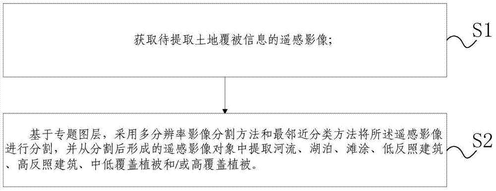
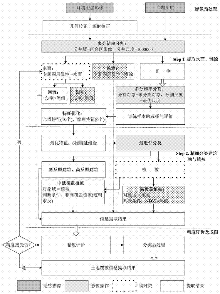
[0016] Such as figure 1 As shown, this embodiment discloses a method for extracting land cover information in remote sensing images, including:

[0017] S1. Obtain the remote sensing image of the land cover information to be extracted;

[0018] S2. Based on the thematic layer, the remote sensing image is segmented using the multi-resolution image segmentation method a...


PUM


Abstract

The invention discloses a method and device for extracting land cover information in remote sensing images, which can solve the problem of inaccurate identification of land cover information in remote sensing images in the prior art. The method includes: acquiring remote sensing images for which land cover information is to be extracted; segmenting the remote sensing images based on a thematic layer by using a multi-resolution image segmentation method and a nearest neighbor classification method, and from the remote sensing image objects formed after segmentation Extract rivers, lakes, tidal flats, low albedo buildings, high albedo buildings, low to medium cover vegetation, and / or high cover vegetation.

Description

technical field [0001] The invention relates to the field of environmental monitoring, in particular to a method for extracting land cover information from remote sensing images. Background technique [0002] With the change of the environment and the development of the economy, it is necessary to identify land classification information on remote sensing images in many occasions, such as land classification information monitoring and environmental monitoring. [0003] The common land classification information recognition method for remote sensing images is based on the pixel-based land cover information recognition method, based on statistical principles, on the premise that the training samples follow the normal distribution, and only use the spectral information of the pixel itself or a certain window around the pixel The texture information in the environment focuses too much on the part, it is difficult to integrate semantic information, and there is a lack of topologi...

Claims


Application Information

Patent Timeline
Patent Type & Authority Patents(China)
IPC IPC(8): G06K9/46G06K9/66
Inventor 孙中平熊文成王昌佐游代安史园莉曹飞姜俊张雪初东
Owner SATELLITE ENVIRONMENT CENT MINIST OF ENVIRONMENTAL PROTECTION
Why Eureka
Try Eureka