Multi-unmanned aerial vehicle scheduling and task planning method for earthquake emergency response

A multi-UAV, emergency response technology, applied in aircraft traffic control, instruments, traffic control systems, etc., can solve the problems of cumbersome process, time-consuming, waste of UAV resources, etc., and achieve the effect of improving efficiency

Active Publication Date: 2015-08-26
CENT SOUTH UNIV
View PDF6 Cites 34 Cited by
  • Summary
  • Abstract
  • Description
  • Claims
  • Application Information

AI Technical Summary

Problems solved by technology

[0005] However, the current domestic UAV dispatching process for emergency response to major geological disasters is mainly through traditional telephones, faxes, etc. The process is cumbersome, time-consuming, and inefficient, and it is impossible to accurately and quickly generate multi-UAV formation task planning solutions , resulting in unclear division of labor after the UAV formations entered the disaster area, and many problems were exposed in the actual earthquake rescue work
For example, in the post-earthquake aeri...

Method used


Image

  • Multi-unmanned aerial vehicle scheduling and task planning method for earthquake emergency response
  • Multi-unmanned aerial vehicle scheduling and task planning method for earthquake emergency response
  • Multi-unmanned aerial vehicle scheduling and task planning method for earthquake emergency response

Examples


Embodiment Construction

[0053] The present invention will be further described below in conjunction with the accompanying drawings and specific embodiments.

[0054] The present invention specifically comprises the following steps:

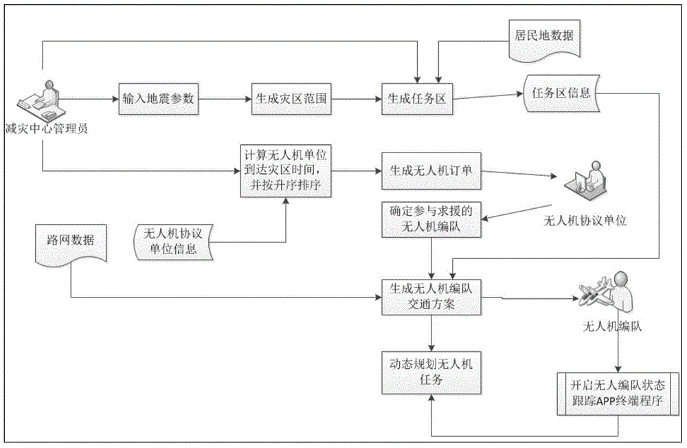
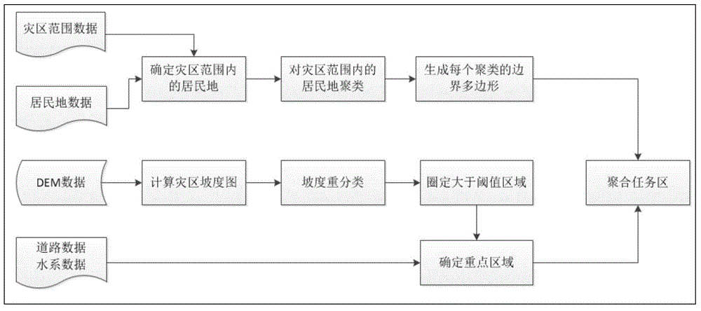
[0055] (1) According to the coordinates of the earthquake source coordinates, depth, magnitude, intensity and other parameters, the scope of the disaster area is automatically generated; combined with the data of residential areas, roads, water systems and digital elevation models, the key monitoring areas of the disaster area are automatically delineated, that is, the mission area.

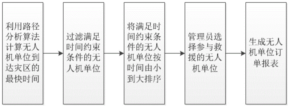
[0056] (2) Combined with the road network data in the disaster area, use the path analysis method to calculate the traffic time and traffic plan required for each UAV unit to reach the disaster area, and generate a corresponding report; the dispatcher of the disaster reduction center determines to participate in post-disaster rescue according to the report and after communication The UAV un...


PUM


Abstract

The invention discloses a multi-unmanned aerial vehicle scheduling and task planning method for earthquake emergency response. The method includes the following three steps of: earthquake disaster area and task area determination; (2) unmanned aerial vehicle department unit ordering and unmanned aerial vehicle formation tracking; and (3) unmanned aerial vehicle formation task planning and dynamic planning. With the multi-unmanned aerial vehicle scheduling and task planning method for earthquake emergency response of the invention adopted, the efficiency of unmanned aerial vehicle scheduling and task planning can be improved, and unmanned aerial vehicle formations can be quickly scheduled to participate in disaster relief.

Description

technical field [0001] The invention belongs to the field of emergency response to major geological disasters, and in particular relates to methods and systems for mobile communication, location-based services, geographic information systems, and multi-drone scheduling and task planning. Background technique [0002] my country is one of the countries with the most serious geological disasters in the world. There are many types of disasters, high frequency of occurrence, wide distribution, and large losses. For example, the Wenchuan earthquake in 2008, the Panzhihua-Huili earthquake in Sichuan, the Yushu earthquake and Zhouqu mudslide in 2010, and the Ya'an earthquake in 2013. The occurrence of geological disasters is unpredictable, not only has great destructive power, but also has caused great economic losses and casualties. It has become one of the important factors affecting my country's economic development and social stability. After an earthquake disaster occurs, act...

Claims


Application Information

Patent Timeline
IPC IPC(8): G08G5/00
Inventor 李光强周晓光尹健肖邱勇王彦坤张攀
Owner CENT SOUTH UNIV
Why Eureka
Try Eureka