Optimum segmentation dimension determining method for remotely-sensed image land cover classification

A technology for remote sensing imagery and surface coverage, which is applied in the field of image processing and can solve problems such as complex, unreasonable algorithms, and different object sizes.

Inactive Publication Date: 2015-09-02
BEIJING NORMAL UNIVERSITY
View PDF4 Cites 25 Cited by
  • Summary
  • Abstract
  • Description
  • Claims
  • Application Information

AI Technical Summary

Problems solved by technology

However, in most cases, the objects in an image are of different sizes, and it is obviously unreasonable to apply the same segmentation scale to objects of different sizes for segmentation
In addition, T.Esch (2008) proposed a method to automatically determine the optimal segmentation scale for different objects, s

Method used


Image

  • Optimum segmentation dimension determining method for remotely-sensed image land cover classification
  • Optimum segmentation dimension determining method for remotely-sensed image land cover classification
  • Optimum segmentation dimension determining method for remotely-sensed image land cover classification

Examples


Embodiment Construction

[0033] In order to have a clearer understanding of the technical features, purposes and effects of the present invention, specific implementations of the present invention are now described. But those skilled in the art should know that the following examples are not the sole limitation to the technical solution of the present invention, and any equivalent transformation or modification made under the spirit of the technical solution of the present invention should be considered as belonging to the protection of the present invention scope.

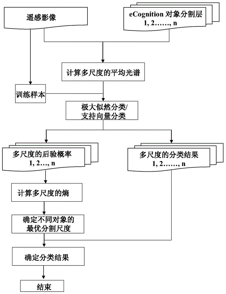
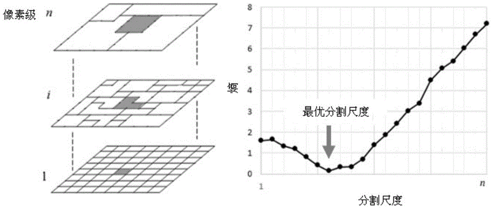
[0034] figure 1 It is a schematic flow chart of a method for determining the optimal segmentation scale for land cover classification of remote sensing images according to a specific embodiment of the present invention; refer to figure 1 As shown, the principle of the optimal segmentation scale determination method for remote sensing image land cover classification provided by the present invention is described in detail below, and the m...


PUM


Abstract

The invention provides an optimum segmentation dimension determining method for remotely-sensed image land cover classification. The method comprises steps of multi-dimension segmentation and classification of remotely-sensed images and optimum dimension selection based on entropy information. The method performs remotely-sensed image classification by integrating a pixel-based classification method and an object-oriented classification method and by fully utilizing sample information, effectively overcomes a problem that a conventional pixel-oriented method generates a large amount of pepper salt noisy points, and achieves automatic selection of object optimum dimension. The invention provides an effective method for land cover drawing.

Description

technical field [0001] The invention relates to a processing method for remote sensing images, in particular to a method for determining an optimal segmentation scale for land cover classification of remote sensing images, and belongs to the field of image processing. Background technique [0002] Land cover refers to the complex of surface elements covered by natural structures and artificial buildings, including surface vegetation, soil, lakes, swamps and various buildings (such as roads, houses, etc.). Land cover is an important forcing factor of global environmental change, which has attracted more and more researchers' attention in recent years. [0003] With the development of remote sensing science and technology, the resolution of remote sensing images is getting higher and higher, which provides feasibility for the mapping of land cover on multiple spatial scales. The classification of remote sensing images is an important link in land cover mapping, which determin...

Claims


Application Information

Patent Timeline
IPC IPC(8): G06K9/62
Inventor 陈学泓杨德地曹鑫陈晋崔喜红
Owner BEIJING NORMAL UNIVERSITY
Why Eureka
Try Eureka