Real-time processing method and system of image data of unmanned plane

A technology of image data and real-time processing, applied in the field of drones, can solve problems such as poor space-time matching

Active Publication Date: 2015-09-09
TIANJIN AEROSPACE ZHONGWEI DATA SYST TECH CO LTD +1
View PDF6 Cites 17 Cited by
  • Summary
  • Abstract
  • Description
  • Claims
  • Application Information

AI Technical Summary

Problems solved by technology

[0006] The purpose of the present invention is to provide a method and system for real-time processing of UAV image data, so as to s

Method used


Image

  • Real-time processing method and system of image data of unmanned plane
  • Real-time processing method and system of image data of unmanned plane
  • Real-time processing method and system of image data of unmanned plane

Examples


Embodiment 1

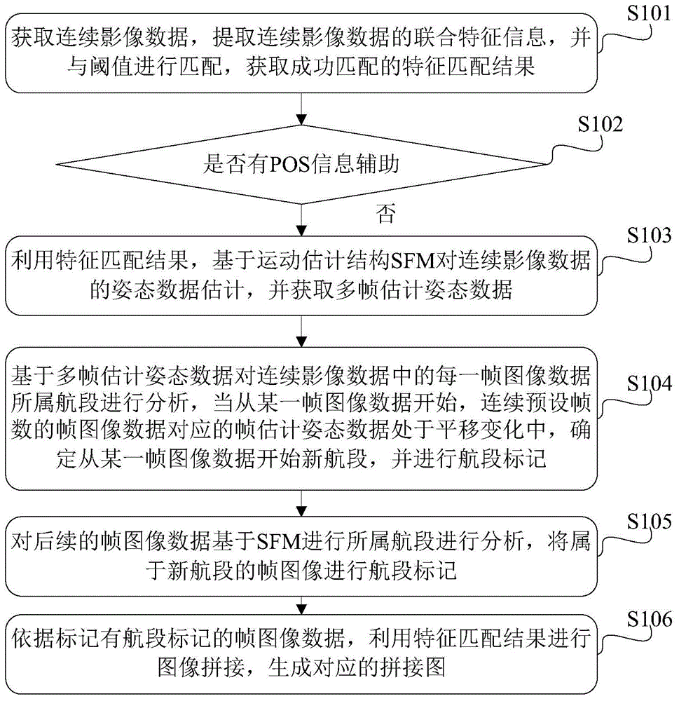
[0070] Embodiment 1 of the present invention provides a method for real-time processing of UAV image data, which is applied to UAVs, such as figure 1 As shown, it mainly includes the following steps:

[0071] Step S101, acquiring continuous image data, extracting joint feature information of the continuous image data, matching the joint feature information with a threshold, and obtaining successfully matched feature matching results;

[0072] In step S101, the joint feature information includes FREAK features and SIFT features; in the embodiment of the present invention, a feature extraction and matching process using a combination of FREAK features and SIFT features is used to meet the real-time processing of UAV image data requirements.

[0073] Step S102, judging whether there is POS information assistance, if there is no POS information assistance, then execute step S103;

[0074] In step S102, it is judged whether there is POS information assistance in the current UAV i...

Embodiment 2

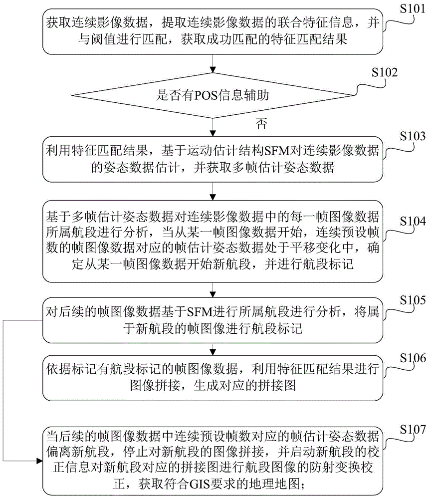
[0085] A method for real-time processing of UAV image data disclosed based on the above-mentioned embodiments of the present invention, such as figure 1 The shown step S105, after performing the analysis of the subsequent frame image data based on the SFM for the flight segment to which it belongs, also includes the following steps: figure 2 Shown:

[0086] Step S107, when the frame estimated attitude data corresponding to the continuous preset number of frames in the subsequent frame image data deviates from the new flight segment, stop the image splicing of the new flight segment, and start the correction information of the new flight segment to update the new flight segment. The mosaic map corresponding to the segment is used to carry out anti-radiation transformation correction of the image of the segment, and obtain a geographical map that meets the requirements of GIS;

[0087] In step S107, the correction information includes track information, or geographical paramet...

Embodiment 3

[0125] Based on the real-time processing method of UAV image data disclosed in the above-mentioned embodiments of the present invention, the corresponding embodiment of the present invention also discloses a real-time processing system for UAV image data, which is also applied to UAVs. Its structural diagram Such as Figure 4 As shown, it mainly includes:

[0126] The extracting and matching device 101 is configured to acquire continuous image data, extract joint feature information of the continuous image data, match the joint feature information with a threshold, and obtain a successfully matched feature matching result, wherein, in the joint feature information Including, FREAK features and SIFT features;

[0127] The judging and estimating device 102 is used to judge whether there is POS information assistance, and if it is judged that there is no POS information assistance, then use the feature matching result to estimate the posture data of the continuous image data bas...


PUM


Abstract

The invention discloses a real-time processing method and system of image data of an unmanned plane. According to the method, matching of combined characteristic information of continuous image data is carried out; a characteristic extraction and matching process based on FREAL and SIFT characteristic combination is used and an image data real-time requirement of the unmanned plane is met. Under the circumstances of no POS information assistance, estimation of attitude data of continuous image data is carried out based on SFM by using a characteristic matching result; and flight track recovery of multiple segments of the unmanned plane is carried out and frame image data at each segment are marked. And then on the basis of the frame image data marked with segment marks, image splicing is carried out based on the characteristic matching result to generate a corresponding spliced image. On the basis of the method, a problem that the telemeasuring data can not be obtained or time-space matching is poor can be solved. And an objective that image data of the unmanned plane can be processed in real time under the circumstances of no POS system assistance can be achieved.

Description

technical field [0001] The present invention relates to the technical field of unmanned aerial vehicles, and more specifically, relates to a method and system for real-time processing of unmanned aerial vehicle image data. Background technique [0002] In view of the current expansion and in-depth development of the application of the drone industry in my country, drones, as an extended platform for remote sensing applications, are playing an increasingly important role in all walks of life. From the analysis of the current integrated use of UAVs, the research and development of UAVs and the research and development of UAV payloads are separate and have a strong independence between the two. As a result, the coupling between the UAV itself and the UAV payload is reduced in other aspects except the mechanical structure, especially the non-openness of some aircraft telemetry information and the non-spatial information of the payload data. synchronicity. [0003] At present, ...

Claims


Application Information

Patent Timeline
IPC IPC(8): G06T3/40
CPCG06T3/4038G06T2200/32
Inventor 燕正亮赵恩伟王诗奎伍小洁张巍杨鹤猛徐瑞张东萍张静张贵峰孟晓波吴新桥
Owner TIANJIN AEROSPACE ZHONGWEI DATA SYST TECH CO LTD
Why Eureka
Try Eureka