
Meteorological power equipment user-defined layer display processing method and system

A technology of power equipment and processing methods, which is applied in the display field of various custom layers, which can solve problems such as display, inability to provide users with queries, layer overlay, cancellation, etc., and achieve the effect of reducing disaster losses

Active Publication Date: 2015-09-30
EMERGENCY MANAGEMENT CENT OF STATE GRID SHANDONG ELECTRIC POWER
View PDF3 Cites 2 Cited by
  • Summary
  • Abstract
  • Description
  • Claims
  • Application Information

AI Technical Summary

Problems solved by technology

[0002] In some existing power meteorological early warning systems, the weather and power equipment layers are not displayed as custom layers such as administrative areas and large area divisions, and cannot provide users with functions such as query, layer overlay, and cancellation

Method used


Image

  • Meteorological power equipment user-defined layer display processing method and system

Examples


Embodiment Construction

[0026] The present invention is described in detail below in conjunction with accompanying drawing:

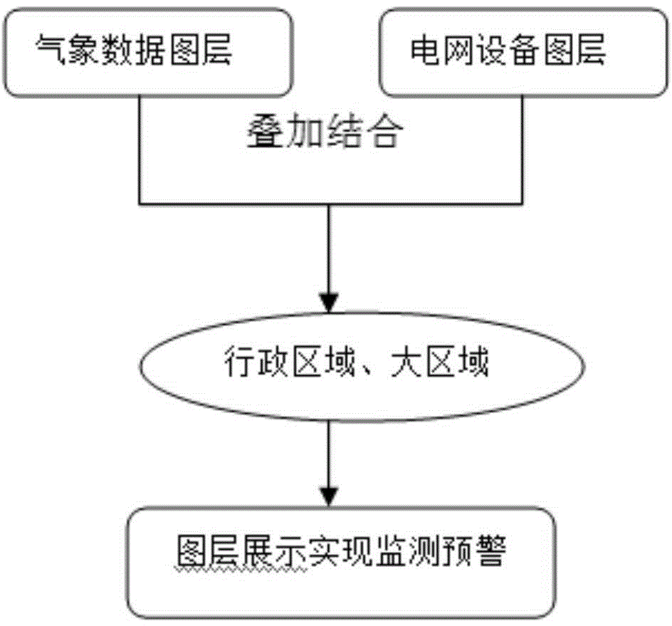
[0027] like figure 1 As shown, the custom layer of meteorological power equipment shows the processing method, including the following steps:

[0028] Step 1: Connect the meteorological data of real-time monitoring and early warning to the GIS platform of the power grid;

[0029] Step 2: According to the location information of electric power equipment and meteorological monitoring stations, respectively establish equipment layers and weather layers in the power grid GIS map, and superimpose the weather layers and equipment layers;

[0030] Step 3: Divide cities and counties into administrative regions or large regions to form a variety of custom layers, and use the custom layers as a blueprint to display the weather information of weather layers and equipment layers.

[0031] In the first step, the power equipment and the weather monitoring station are positioned on the gri...


PUM


Abstract

The invention discloses a meteorological power equipment user-defined layer display processing method and system. The method includes: connecting meteorological data which are monitored in realtime and prewarned into a power grid GIS platform, positioning power equipment and a meteorological monitoring station in the power grid GIS platform, and positioning coordinates of the meteorological monitoring station into a power grid GIS map; creating an equipment layer and a meteorological layer in the power grid GIS map respectively according to positioning information of the power equipment and the meteorological monitoring station, and stacking the meteorological layer and the equipment layer; dividing according to municipal and prefectural administrative regions or large regions to form various user-defined layers, and taking the user-defined layers as blueprints to display meteorological information of the meteorological layer and the equipment layer. Monitoring and prewarning of natural disasters and emergent events can be realized by taking dynamic correlation of meteorological-power equipment as a basis through layer display, and disaster loss can be reduced to greatest extent.

Description

technical field [0001] The invention relates to a method for displaying layer status information of grid meteorological equipment, in particular to a method for displaying multiple user-defined layers such as grid equipment status in terms of administrative areas and large area divisions. Background technique [0002] In some existing power meteorological early warning systems, the weather and power equipment layers are not displayed as custom layers such as administrative areas and large area divisions, and cannot provide users with functions such as query, layer overlay, and cancellation. From the visual display of graphic resources on the power grid GIS platform and the early warning requirements of the comprehensive monitoring and early warning system for power grid disaster prevention and mitigation, layer information is displayed in administrative areas, which is an inevitable trend for users to query. Contents of the invention [0003] In order to solve the deficien...

Claims


Application Information

Patent Timeline
Patent Type & Authority Applications(China)
IPC IPC(8): G06F17/30G06F19/00
CPCY02A90/10
Inventor 孙世军张治取孙为民王波汪友杰杨啸帅韩洪张鹏程中华
Owner EMERGENCY MANAGEMENT CENT OF STATE GRID SHANDONG ELECTRIC POWER
Learn More