A Space Syntax Based Prediction Method for Urban Expansion Boundary

An urban sprawl, space syntax technology, used in forecasting, data processing applications, instrumentation, etc.

Inactive Publication Date: 2017-11-28
WUHAN UNIV
View PDF3 Cites 2 Cited by
  • Summary
  • Abstract
  • Description
  • Claims
  • Application Information

AI Technical Summary

Problems solved by technology

Since the emergence of space syntax, there have been a lot of research results on the city scale, but there are few research results on the expansion of city boundaries based on space syntax

Method used


Image

  • A Space Syntax Based Prediction Method for Urban Expansion Boundary
  • A Space Syntax Based Prediction Method for Urban Expansion Boundary
  • A Space Syntax Based Prediction Method for Urban Expansion Boundary

Examples


Embodiment Construction

[0055] In order to facilitate those of ordinary skill in the art to understand and implement the present invention, the present invention will be described in further detail below in conjunction with the accompanying drawings and embodiments. It should be understood that the implementation examples described here are only used to illustrate and explain the present invention, and are not intended to limit this invention.

[0056] A kind of urban sprawl boundary prediction method based on space syntax provided by the present invention comprises the following steps:

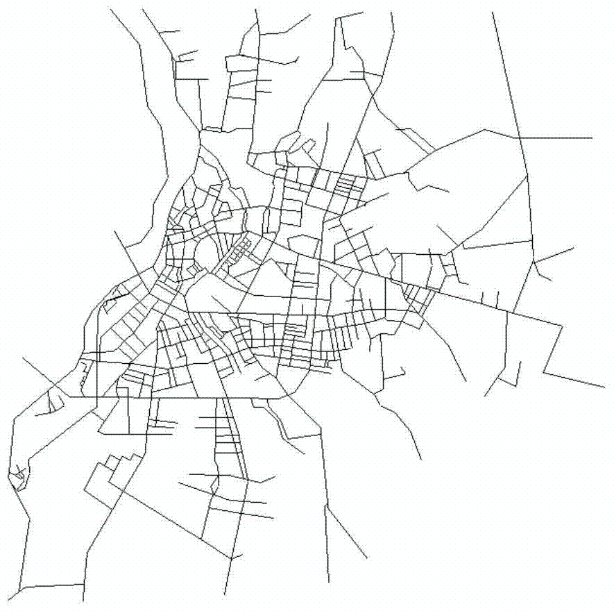
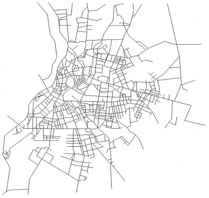
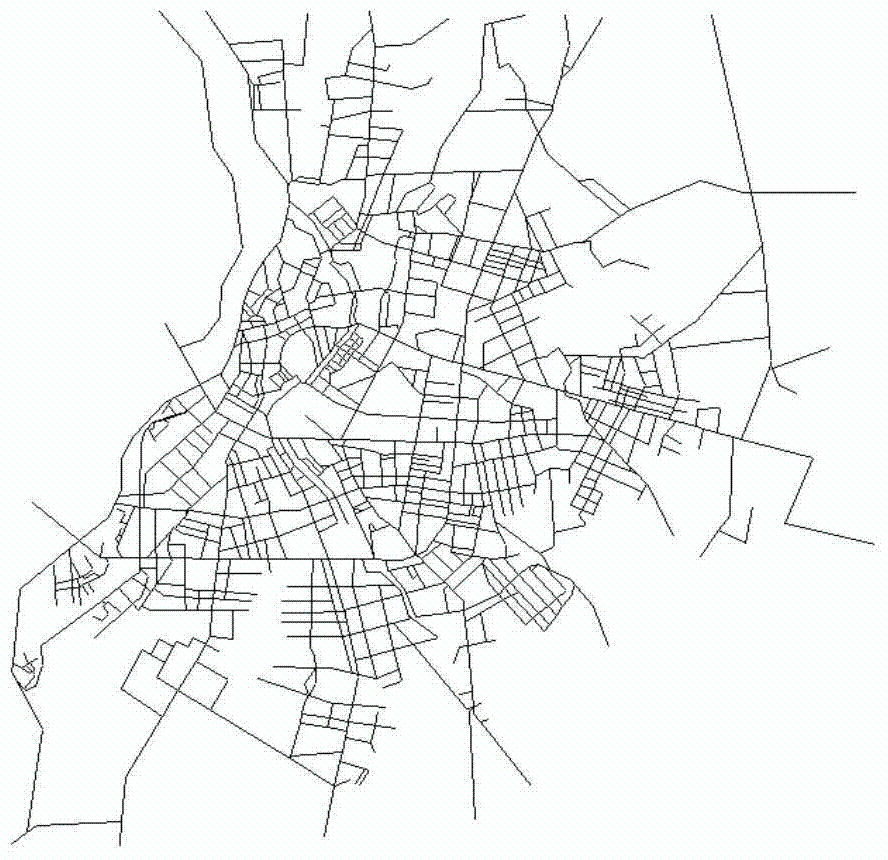
[0057] Step 1: Extract the boundary of urban built-up areas and draw a line segment map based on space syntax. The specific implementation includes the following sub-steps:

[0058] Step 1.1: Use ArcGIS software to extract the boundary map of the built-up area through visual interpretation based on the radiometric and geometrically corrected remote sensing images, including three periods of history, current situatio...


PUM


Abstract

The invention discloses a method for predicting the boundary of urban expansion based on space syntax, comprising the following steps: 1) drawing a segment map (Segment Map) and extracting the boundary of built-up areas; 2) establishing a fixed grid unit; 3) calculating the form of space syntax Analyze variables and assign values ​​to the grid; 4) Calculate the distance from each grid to the boundary of the built-up area; 5) Establish and test the multiple linear regression model; 6) Predict the boundary of urban expansion. The method of the invention constructs a quantitative model between the built-up area boundary and the space syntax morphological analysis variables, and applies the above model to the prediction of the urban expansion boundary, which can provide new ideas for urban planning decision-making and urban boundary research to a certain extent.

Description

technical field [0001] The invention relates to a method for predicting the boundary of urban expansion, in particular to a method for predicting the boundary of urban expansion based on space syntax. Background technique [0002] my country's urbanization process is accelerating, how to effectively control urban growth is an important topic of urban development research. Since the urban system is affected by many factors, and its internal spatial activities are complex and changeable, previous studies on cities focused on analyzing economic and social factors, and believed that the shape and mode of urban space are only their projections on the region, and they are economic and social processes. Shaped the physical city. Most of the models for predicting expansion boundaries based on this urban analysis method consider many factors and are relatively complex, such as cellular automata model, SLEUTH model, CLUE-S model, binary logistic regression model, multivariate logisti...

Claims


Application Information

Patent Timeline
Patent Type & Authority Patents(China)
IPC IPC(8): G06F17/50G06Q10/04
Inventor 王海军张安琪夏畅宋丹阳
Owner WUHAN UNIV
Why Eureka
Try Eureka