Route planning method and device

A path planning and planning technology, applied in the field of maps, can solve the problems of long update cycle of map quotient data, large search space, and difficulty in ensuring the accuracy of map quotient data, so as to improve the efficiency of path planning, reduce the search space, and overcome the problems of planning. Inaccurate effects

Active Publication Date: 2015-11-11
BAIDU ONLINE NETWORK TECH (BEIJIBG) CO LTD
View PDF8 Cites 35 Cited by
  • Summary
  • Abstract
  • Description
  • Claims
  • Application Information

AI Technical Summary

Problems solved by technology

However, on the one hand, the current branch reduction strategies are all based on graph vendor data, and the search space is still large; on the other hand, the update cycle of graph vendor data is too long, and the accuracy of graph vendor data itself is difficult to guarantee. When a road section is being repaired or has been abandoned, the map provider data is not updated, which may lead users to an unsmooth path as a result of route planning, resulting in a poor user experience

Method used


Image

  • Route planning method and device
  • Route planning method and device
  • Route planning method and device

Examples


Embodiment 1

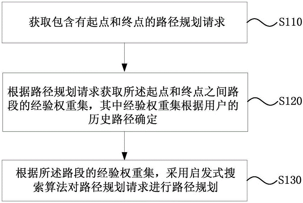
[0022] figure 1 It is a schematic flowchart of a path planning method provided in Embodiment 1 of the present invention. This embodiment is applicable to the situation of electronic map route planning in the navigation terminal. The method can be executed by a route planning device, which can be realized by software and integrated in a server that provides navigation services for navigation products. see figure 1 , the path planning method provided in this embodiment specifically includes the following operations:

[0023] Operation 110. Obtain a path planning request including a starting point and an ending point.

[0024] Specifically, the navigation terminal may receive a route planning request triggered by the user through human-computer interaction, and the request includes the starting point and the ending point of the route that the user wants to walk. For example, a human-computer interaction interface corresponding to path planning can be provided, which includes ...

Embodiment 2

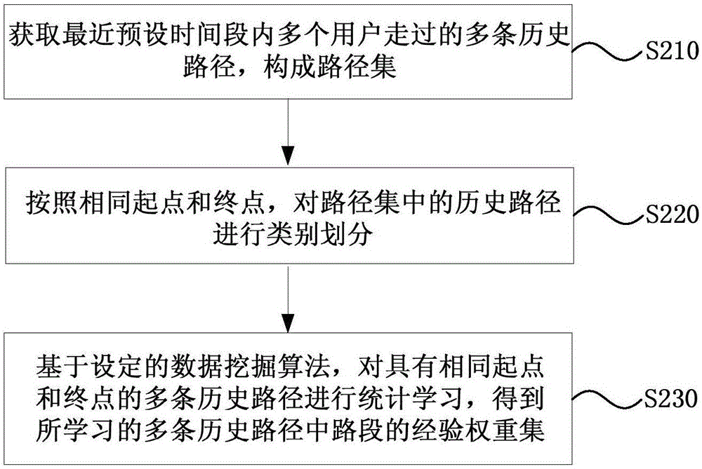
[0042] In this embodiment, on the basis of the first embodiment above, the method for offline determination of the experience weight sets of each road section between the starting point and the ending point is introduced in detail. see figure 2 , the determination method specifically includes the following operations:

[0043] Operation 210. Acquire multiple historical paths traveled by multiple users within a recent preset time period to form a path set.

[0044] Since the embodiment of the present invention performs route planning based on the user's road use experience, the historical route of the user should also be the route traveled by the user in a recent period of time. If the historical path is too far away from the current time, the accuracy of learning will be reduced. The preset time period may be the last month or half a year, and may be set by the developer himself.

[0045] The historical path may be triggered by the navigation terminal to report actively af...

Embodiment 3

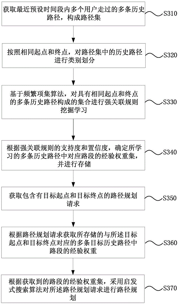
[0068] image 3 It is a schematic flowchart of a path planning method provided in Embodiment 3 of the present invention. This embodiment provides a preferred embodiment based on all the above embodiments. see image 3 , the method specifically includes the following operations:

[0069] Operation 310. Acquire multiple historical paths traveled by multiple users within a recent preset time period to form a path set.

[0070] Operation 320. Classify the historical routes in the route set according to the same start point and end point.

[0071] Operation 330. Based on the frequent itemset algorithm, perform strong association rule mining and learning on a set composed of multiple historical paths with the same start point and end point.

[0072] In this embodiment, during the mining and learning process, only frequent 2-item sets may be mined first; then strong association rules may be mined from the frequent 2-item sets. In this way, the left and right segments in the rule...


PUM


Abstract

The embodiment of the invention discloses a route planning method and device. The method comprises the steps of acquiring a route planning request containing a start point and an end point; acquiring an experience weight set of a section between the start point and the end point according to the route planning request, wherein the experience weight set is determined according to historical routes of a user; according to the experience weight set of the section, performing route planning for the route planning request by adopting a heuristic search algorithm. According to the technical scheme provided by the embodiment of the invention, an existing route planning technology can be optimized, and planning speed and planning result accuracy can be improved.

Description

technical field [0001] The embodiments of the present invention relate to the field of map technology, and in particular to a path planning method and device. Background technique [0002] At present, navigation products integrating positioning, navigation, entertainment and other functions have gradually become the basic equipment on the car. As a very important function in navigation, electronic map path planning can select the best walking path from many paths to the destination and provide it to the car owner, so that the car owner can reach the destination quickly and conveniently. [0003] The route of route planning is organized by each Link (section), and a route can contain multiple Link data. Link is the smallest unit in map data, used to represent a road segment in the actual road network. The LinkID field is the unique identifier of Link data in the road network. The main process of the current path planning algorithm is to expand the depth or breadth of the l...

Claims


Application Information

Patent Timeline
Patent Type & Authority Applications(China)
IPC IPC(8): G01C21/34
CPCG01C21/3446
Inventor 汪洋
Owner BAIDU ONLINE NETWORK TECH (BEIJIBG) CO LTD
Why Eureka
Try Eureka