Method for quickly planning and mixing paths on basis of A-star algorithms

A fast path and algorithm technology, applied in the directions of road network navigators, measuring devices, instruments, etc., can solve problems such as large search space, long time consumption, and low solution efficiency.

Active Publication Date: 2016-07-13
DALIAN NEUSOFT UNIV OF INFORMATION
View PDF5 Cites 25 Cited by
  • Summary
  • Abstract
  • Description
  • Claims
  • Application Information

AI Technical Summary

Problems solved by technology

The traditional classic algorithm of the best path is the Dijkstra algorithm. This algorithm is based on the network model in graph theory. It is possible and ready to search for all network nodes when solving the problem. However, when the map scale is large and the number of urban road network nodes is large In the case of a static road network, the algorithm takes a long time and the solution efficiency is low, and it is difficult to meet the requirements of the rapidity of the actual path dynamic planning; another most effective method f...

Method used


Image

  • Method for quickly planning and mixing paths on basis of A-star algorithms
  • Method for quickly planning and mixing paths on basis of A-star algorithms
  • Method for quickly planning and mixing paths on basis of A-star algorithms

Examples


Embodiment Construction

[0035] In order to make the purpose, technical solutions and advantages of the embodiments of the present invention more clear, the technical solutions in the embodiments of the present invention are clearly and completely described below in conjunction with the drawings in the embodiments of the present invention:

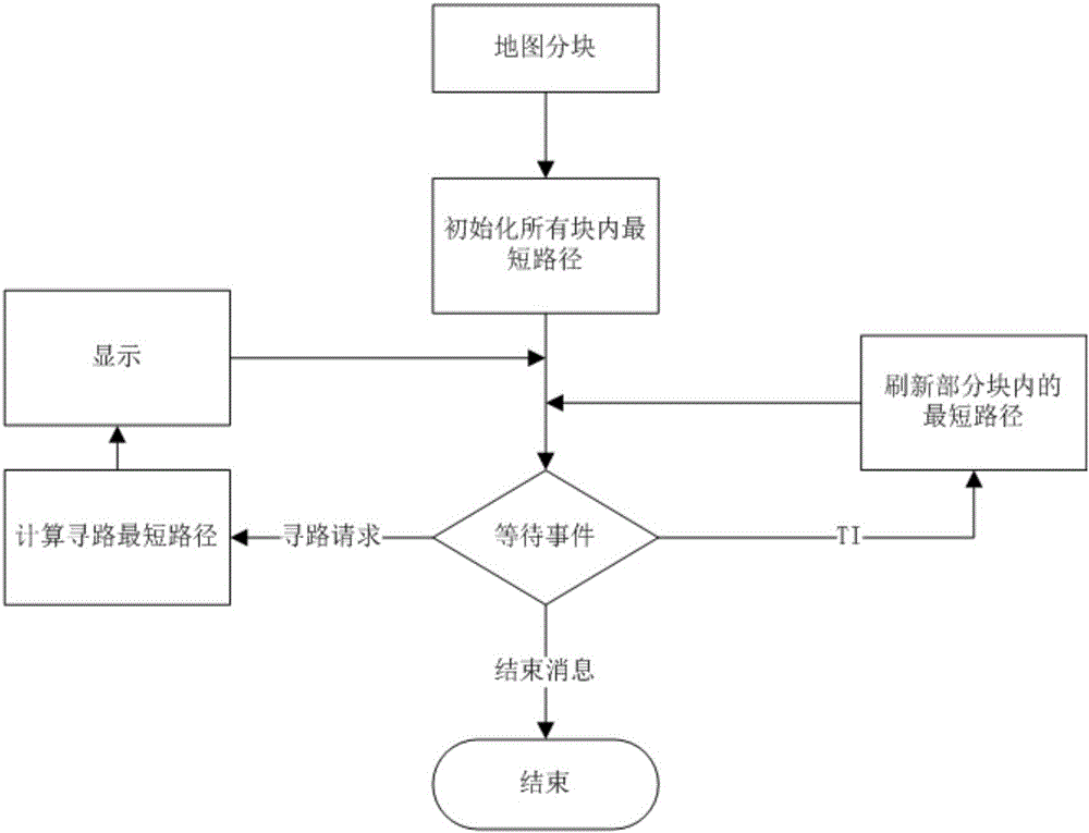
[0036] like figure 1 ‐5 shows: a fast path planning hybrid method based on the A‐Star algorithm, which mainly includes the following steps:

[0037] First, the target map is divided into multiple map blocks of equal size according to the longitude and latitude lines, and each map block is the area enclosed by the longitude and latitude lines.

[0038] t i (i∈Z, and 0≤i≤n) is the dimension of the i-th dividing parallel, where t 0 = -85°, t n = 85°;

[0039] g j (j∈Z, and 0≤i≤n) is the accuracy of the j-th segmented police rank, where g 0 = -180°, g m = 180°;

[0040] t i and g j Represents latitude and longitude lines.

[0041] have t i+1 -t i =T, wh...


PUM


Abstract

The invention discloses a method for quickly planning and mixing paths on the basis of A-star algorithms.The method includes steps of S1, dividing a target map into a plurality of map blocks with equal sizes; computing and storing the shortest paths between all adjacent points and nodes in each map block; S2, judging affected road segments in the map blocks affected by events when the events occur, computing the shortest paths among all the adjacent points and the nodes in each map block related to the affected road segments after the affected road segments are excluded; S3, selecting the various map blocks, where paths from start points to end points pass, on the basis of the A-star algorithms, and connecting the shortest paths in the various map blocks with one another after the affected segments are excluded so as to form a plurality of alternative paths.The adjacent points represent intersection points of boundaries of roads and the map blocks, and the nodes are the start points or cross points of the roads.The alternative paths with the minimum time cost are the optimal paths.

Description

technical field [0001] The invention discloses a path planning hybrid method, in particular to a fast path planning hybrid method based on Astar algorithm and equal-size map block division. Involving patent classification G01 Surveying; Testing G01C Measuring distance, level or bearing; Surveying; Navigation; Gyroscope; Photogrammetry or videogrammetry G01C21 / 00 Navigation; G01C21 / 26 Navigation dedicated to road networks G01C21 / 34 Route search; route guidance. Background technique [0002] The vehicle navigation system refers to the use of certain positioning and navigation technologies to enable the vehicle to display the physical location of the vehicle in real time during driving, plan the optimal driving route for the vehicle from the starting point to the end point, and guide the vehicle to follow the optimal path. Route planning is the process of planning the optimal driving route before or during driving based on the urban road network map. In order to meet the actu...

Claims


Application Information

Patent Timeline
IPC IPC(8): G01C21/34
CPCG01C21/3446
Inventor 周慧李迎秋刘振宇张永
Owner DALIAN NEUSOFT UNIV OF INFORMATION
Why Eureka
Try Eureka