Sensor data collection

A sensor and place technology, applied in the field of sensor data collection, which can solve problems such as GPS positioning of surveyors

Active Publication Date: 2015-11-11
MICROSOFT TECH LICENSING LLC
View PDF7 Cites 5 Cited by
  • Summary
  • Abstract
  • Description
  • Claims
  • Application Information

AI Technical Summary

Problems solved by technology

But since the location being measured is part of the GPS dead zone, GPS is likely to be unusable to facilitate locati...

Method used


Image

  • Sensor data collection
  • Sensor data collection
  • Sensor data collection

Examples


Embodiment Construction

[0017] People want to have maps so they know where they are, so they know where they've been, so they'll know how to get from where they are to where they want to go, and for other reasons consideration. For example, when in a mall, a shopper may want to know how to get from one store to another. Similarly, in a large office building, someone in the mail room may want to know how to get to a particular worker's desk so that mail can be delivered. Likewise, in a maze of underground sewer pipes, a worker may want to know how to get to a specific cleaning valve. Unfortunately, the map about the location will change. For example, for a place, there may be two, three, or twelve map revisions.

[0018] Additionally, the physical configuration of a mall, office building, or underground pipeline network may vary. More generally, the physical reality of the physical geography may change or the mapping of locations may change. These changes can occur so rapidly that maps quickly be...


PUM


Abstract

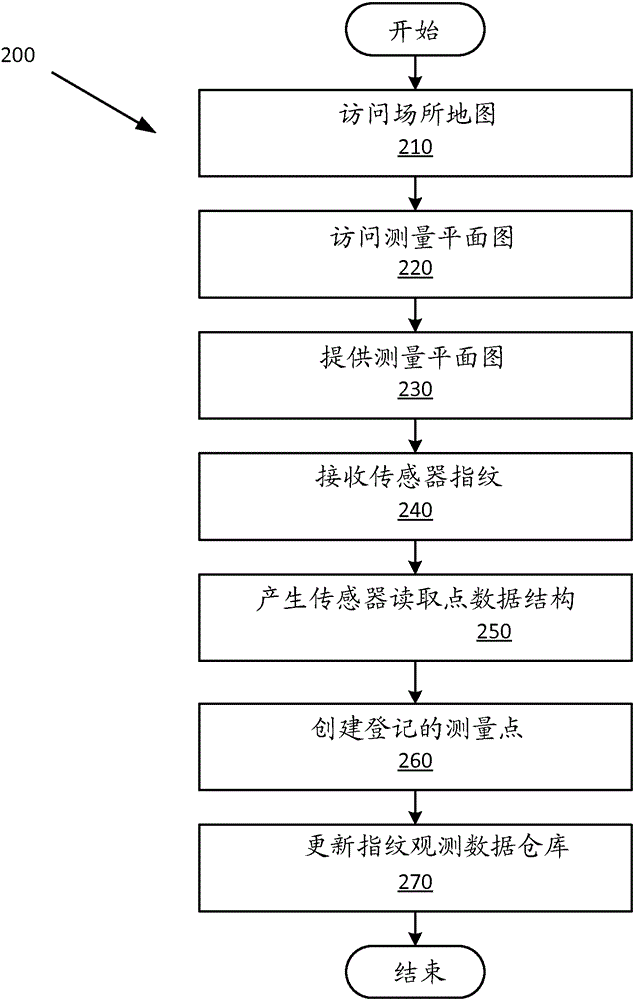
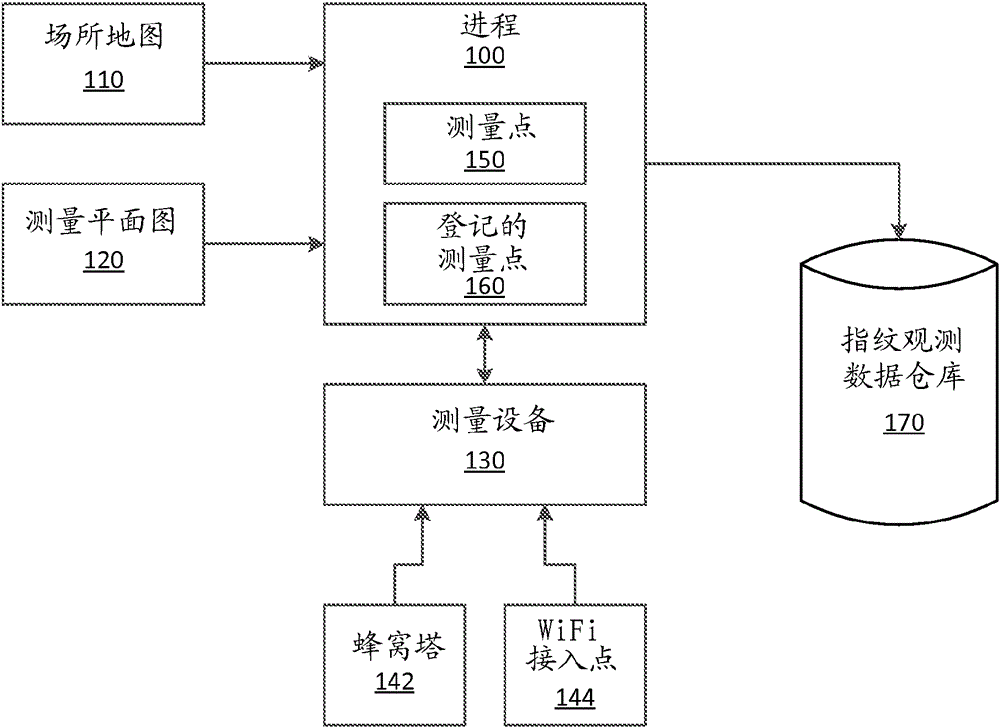
Example apparatus and methods concern rigorous survey-plan based sensor data collection where physical survey locations are correlated to logical locations rather than being tightly coupled to physical map locations. An embodiment includes accessing a venue map and a survey plan associated with the venue map. A survey plan includes a survey path defined by one or more logical survey points. A logical survey point includes a unique co-ordinate free identifier, a description of a recognizable location in the venue, and a co-ordinate configured to register the logical survey point to the corresponding venue map. A surveyor surveys the venue using the survey plan. Surveying the venue includes following the survey plan and acquiring sensor fingerprints at sensor reading points along the survey path. A fingerprint observation data store is populated with survey points that are registered to the survey plan. Survey points include sensor fingerprint data and correlation data.

Description

Background technique [0001] People want to have maps so they know where they are, so they can figure out how to get from where they are to somewhere else. People also love their mobile devices (eg, cell phones). One use of mobile devices is to provide maps, location services, directions services, and other positioning services. Conventionally, location services for mobile devices have been supported by the Global Positioning System (GPS). GPS works well outdoors and when enough satellites are within line-of-sight of the device. However, conventional GPS-based positioning or mapping services may not work when line-of-sight to a sufficient number of satellites is not available. In locations such as inside buildings, under bridges, underground, and during GPS outages, loss of line of sight to a sufficient number or type of satellites can result in the existence of GPS "dead zones." Even if the person or machine is in a GPS dead zone (eg, an area where GPS cannot provide satis...

Claims


Application Information

Patent Timeline
IPC IPC(8): G06F17/40
CPCG01C21/206G01S5/02G01S5/0252G06F17/30595G01S2205/02G01S5/02525G01S5/02524G01S5/0295G06F16/284
Inventor 林志翰C-W.王S.迪亚塞蒂斯
Owner MICROSOFT TECH LICENSING LLC
Why Eureka
Try Eureka