Inertial navigation device

A technology of a navigation device and an inertial navigation module, applied in the field of satellite navigation, can solve the problems of ineffective positioning and discontinuous navigation, and achieve the effect of high positioning accuracy and improving positioning accuracy.

Inactive Publication Date: 2015-11-25
浙大正呈科技有限公司
View PDF5 Cites 8 Cited by
  • Summary
  • Abstract
  • Description
  • Claims
  • Application Information

AI Technical Summary

Problems solved by technology

[0004] The disadvantage of the current GPS satellite navigation device is that it needs to rely on the received satellite signals to carry out effective positioning. In order to output effective position information, the satellite signal receiving module should send the satellite signals of at least four satellites to the data calculation module. However, when the vehicle is driving in urban canyons, underground garages, elevated roads, tunnels, etc., it cannot or can only receive a small amount of satellite information, for example, it can only receive satellite signals from three satellites. At this time, it cannot be effectively positioned. , causing discontinuous navigation

Method used


Image

  • Inertial navigation device
  • Inertial navigation device

Examples


Embodiment Construction

[0031] In order to make the present invention more clear, the present invention will now be explained in more detail in conjunction with the accompanying drawings and embodiments.

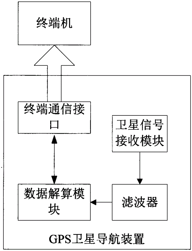
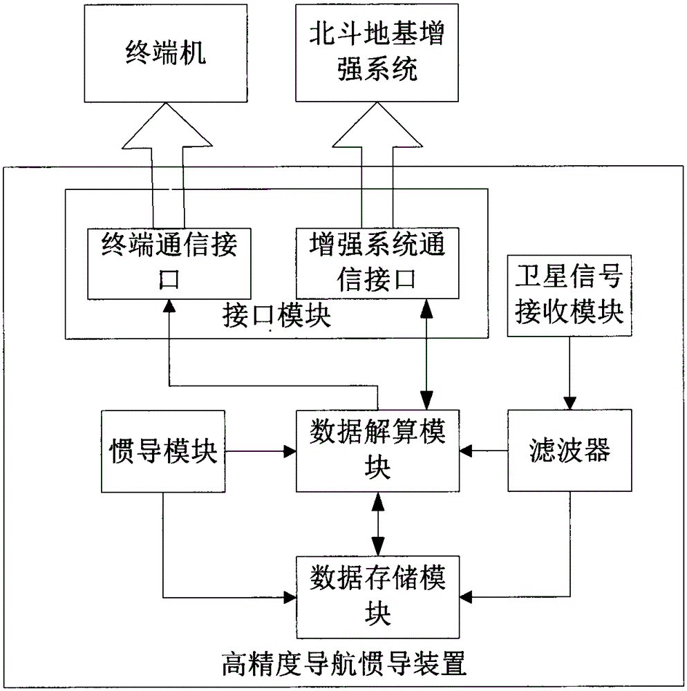
[0032] The inertial navigation device of one embodiment of the present invention is as figure 2 As shown, it includes: a satellite signal receiving module, a filter, a data calculation module, a data storage module, an inertial navigation module, and a communication interface for communicating with a terminal ( figure 2 The middle is the terminal communication interface) and the communication interface with the Beidou ground-based augmentation system ( figure 2 The medium is the enhanced system communication interface). Wherein, both the terminal communication interface and the enhanced system communication interface are set in the interface module. The inertial navigation module in the current embodiment is a strapdown inertial navigation module.

[0033] The terminals supported by the inert...


PUM


Abstract

The invention discloses an inertial navigation device, which comprises a filter, a data solution module and an inertial navigation module, wherein the filter carries out noise filtering on received satellite signals to obtain ephemeris data; according to the ephemeris data from the filter, the data solution module calculates position coordinates and sends the position coordinates to a terminal; and the inertial navigation module sends inertial navigation data to the data solution module such that when the data solution module receives ephemeris data of less than four satellites, the data solution module calculates in a combined mode and outputs position coordinates according to the inertial navigation data. According to the inertial navigation device, continuous, seamless and accurate navigation and positioning functions in urban canyons, underground garages, elevateds, tunnels and other conditions.

Description

technical field [0001] The invention relates to the field of satellite navigation, in particular to an inertial navigation device. Background technique [0002] GPS satellite navigation devices in the prior art such as figure 1 As shown, it includes: a satellite signal receiving module, a filter, a data calculating module, and a communication interface. [0003] The main implementation scheme is: the satellite signal receiving module directly receives the satellite signal, inputs the satellite signal into the filter, and the filter denoises the satellite signal to obtain the ephemeris data and sends it to the data calculation module, and the data calculation module according to All the obtained ephemeris data is calculated to obtain the position coordinates, and the position coordinates are sent to the terminal, and the output result is the position coordinates of the single point positioning. [0004] The disadvantage of the current GPS satellite navigation device is that...

Claims


Application Information

Patent Timeline
Patent Type & Authority Applications(China)
IPC IPC(8): G01S19/49
CPCG01S19/49
Inventor 蒋建华李东红李帅晏敏司九鼎叶力萌
Owner 浙大正呈科技有限公司
Why Eureka
Try Eureka