Measuring and calculating method for length of deep pool segment of step-deep pool type debris flow drainage canal
A technology for draining guide troughs and debris flows, applied in water conservancy projects, artificial waterways, buildings, etc., can solve problems such as the inapplicability of the projection distance formula, few considerations, and failure to reasonably determine the length of the deep pool section
- Summary
- Abstract
- Description
- Claims
- Application Information
AI Technical Summary
Problems solved by technology
Method used
Image
Examples
Embodiment 1
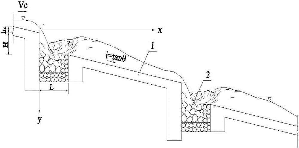
[0064] Such as figure 2 shown. A debris flow ditch is located in Xincheng District, Jiuzhaigou County, Sichuan Province, and is a tributary ditch on the left bank of Baishui River, a tributary of the upper reaches of Jialing River. Groove area: 23.41km 2 ; The length of the main ditch: 8.20km; the elevation of the highest point: 3643m; the elevation of the mouth of the ditch: 1402m; the relative height difference: 2200m; The watershed of the ditch is "thin and wide", with a wide upper reaches and gradually tightens downwards. Its shape is similar to a fan. There are two main threat areas, Shuanglong Village in the middle reaches and Xincheng District in the lower reaches. Thousands of residents and roads in the watershed , Buildings may be directly or indirectly affected by mudslides.
[0065] In order to effectively guide debris flow, prevent debris flow from harming residents and buildings, and reduce debris flow disasters, it is proposed to build a ladder-deep pool type...
Embodiment 2
[0079] Such as figure 2shown. A debris flow ditch is located in the northwest of Mianzhu City, on the left bank of the Mianyuan River. It is a typical representative of debris flow ditch with multiple sources, large gradient and small watershed after the earthquake. Groove area: 1.36km 2 ; Main ditch length: 2.59km; highest point elevation: 1980m; ditch mouth elevation: 960m; relative height difference: 1020m; average vertical gradient: 625‰. Before the earthquake, the ditch was a mountain torrent ditch. After the "5.12" earthquake, the middle and upper mountain body produced a collapse debris flow, which accumulated in the ditch and formed a debris flow under the action of rainfall. From June 2008 to September 2011, a total of 5000m 3 More than 10 times of the above mudslide activities not only buried the Hanwang-Qingping Highway, the lifeline of the ditch mouth, but also blocked the Mianyuan River many times, forming a mudslide barrier lake. After engineering treatment,...
PUM
 Abstract
Description
Claims
Application Information
 - R&D
- Intellectual Property
- Life Sciences
- Materials
- Tech Scout
- Unparalleled Data Quality
- Higher Quality Content
- 60% Fewer Hallucinations
Browse by: Latest US Patents, China's latest patents, Technical Efficacy Thesaurus, Application Domain, Technology Topic, Popular Technical Reports.
© 2025 PatSnap. All rights reserved.Legal|Privacy policy|Modern Slavery Act Transparency Statement|Sitemap|About US| Contact US: help@patsnap.com


