Panorama image stitching method based on three-dimensional laser point cloud

A panoramic image, three-dimensional laser technology, applied in the field of surveying and mapping geographic information, to achieve the effect of high practical application value, shorten the production cycle, and reduce the workload of manual editing

Active Publication Date: 2016-01-13
WUHAN HI TARGET DIGITAL CLOUD TECH CO LTD
View PDF4 Cites 25 Cited by
  • Summary
  • Abstract
  • Description
  • Claims
  • Application Information

AI Technical Summary

Problems solved by technology

[0014] The present invention provides a method for stitching panoramic images based on three-dimensional laser point clouds. When calculating the corresponding relationship between the target image pixels and the original image pixels, the actual object coordinates provided by the point cloud data are used to solve the problems in the existing panoramic stitching methods. Insufficient, can improve the splicing accuracy

Method used


Image

  • Panorama image stitching method based on three-dimensional laser point cloud
  • Panorama image stitching method based on three-dimensional laser point cloud
  • Panorama image stitching method based on three-dimensional laser point cloud

Examples


Embodiment Construction

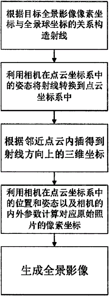
[0044] The present invention will be described in detail below in conjunction with specific embodiments.

[0045] The acquisition device used in this embodiment is a vehicle-mounted mobile measurement system, the object of data acquisition is a street, and the collected data are point cloud data of the street and original panoramic camera data. The vehicle-mounted mobile measurement system has been calibrated, that is, the position and attitude angle of the panoramic camera at the moment of taking pictures in the point cloud coordinate system are known, the internal parameters of each lens of the panoramic camera are known, and the position and attitude angle of each lens in the panoramic camera coordinate system are known. A known.

[0046] According to the steps described above, first set the resolution of the target panoramic image to be 2d×d.

[0047] Take the pixel coordinates (u, v) of the target panoramic image for horizontal and vertical circulation, and calculate the...


PUM


Abstract

The invention provides a panorama image stitching method based on three-dimensional laser point cloud, and the method comprises the following steps during calculating pixel coordinates of a raw image corresponding to a target panorama image: 1) constructing a ray according to pixel coordinates of the target panorama image, and converting a ray in a point cloud coordinate system through employing the posture of a camera in the point cloud coordinate system; 2) obtaining three-dimensional coordinates in the ray direction through neighbor point cloud interpolation; 3) calculating pixel coordinates corresponding to the raw image through employing the position and posture of the camera in the point cloud coordinate system and the internal and external parameters of the camera according to the three-dimensional coordinates. The method provided by the invention irons out the defects of a conventional panorama image stitching method, can improve the stitching accuracy, reduces the manual operation, shortens the data production cycle, and has very high economic and social values.

Description

technical field [0001] The invention relates to a panoramic image splicing method based on a three-dimensional laser point cloud, belonging to the field of surveying and mapping geographic information. Background technique [0002] Street view service is the hotspot of Internet map at present. Street view data is generally collected by a vehicle-mounted panoramic camera, and the panoramic image is obtained after post-processing, and then released to the Internet. Street view maps require that panoramic images have no traces of visual splicing, so the internal and external parameters of the camera need to be accurately calibrated during stitching, and a strict projection model is used to project the original image onto a spherical surface to generate a panoramic image. [0003] Existing projection methods are generally as follows: [0004] First, construct a panoramic sphere with a radius R, the center of which is the center of the panoramic camera, and each point on the pa...

Claims


Application Information

Patent Timeline
Patent Type & Authority Applications(China)
IPC IPC(8): G06T3/40
CPCG06T3/4038
Inventor 汪开理刘守军姚立
Owner WUHAN HI TARGET DIGITAL CLOUD TECH CO LTD
Why Eureka
Try Eureka