Navigation and positioning method and device

A technology of navigation and positioning and position information, which is applied in the direction of measuring devices, road network navigators, satellite radio beacon positioning systems, etc., and can solve the problems of positioning failure and low positioning accuracy

Inactive Publication Date: 2016-02-03
北京易行出行旅游有限公司
View PDF10 Cites 35 Cited by
  • Summary
  • Abstract
  • Description
  • Claims
  • Application Information

AI Technical Summary

Problems solved by technology

[0005] The embodiment of the present invention provides a navigation and positioning method and device to solve the problem that the GPS receiv

Method used


Image

  • Navigation and positioning method and device
  • Navigation and positioning method and device
  • Navigation and positioning method and device

Examples


Embodiment 2

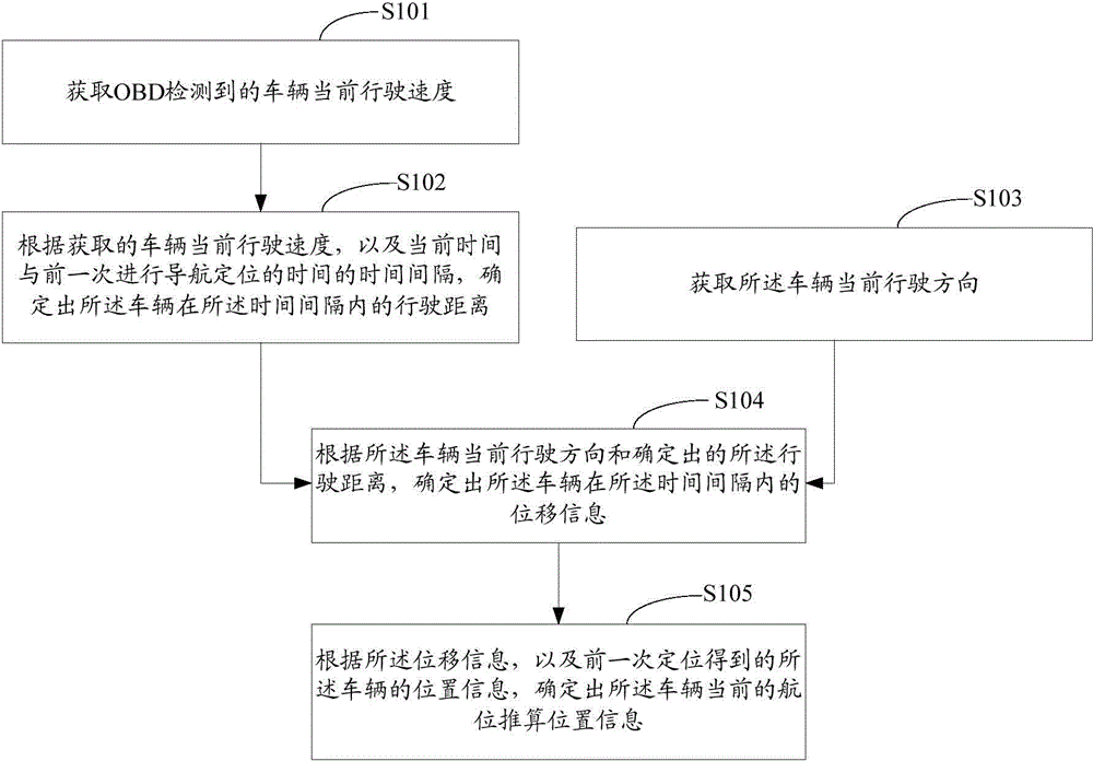
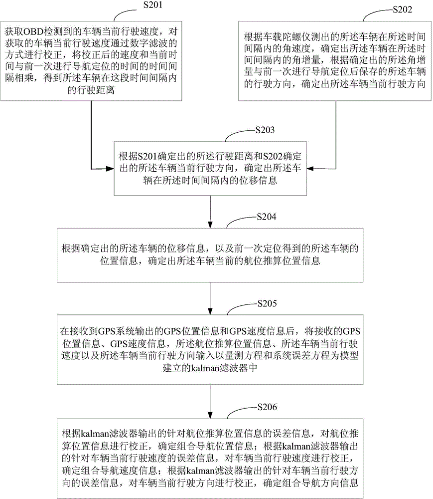
[0085] Such as figure 2 As shown, it is a flow chart of the navigation and positioning method provided by Embodiment 2 of the present invention, image 3 It is a schematic diagram of various signals for navigation and positioning corresponding to the second embodiment; the method flow of the second embodiment includes:

[0086] S201: Obtain the current driving speed of the vehicle detected by OBD, correct the obtained current driving speed of the vehicle through digital filtering, multiply the corrected speed and the current time by the time interval of the previous navigation and positioning time, and obtain The distance traveled by the vehicle during the time interval.

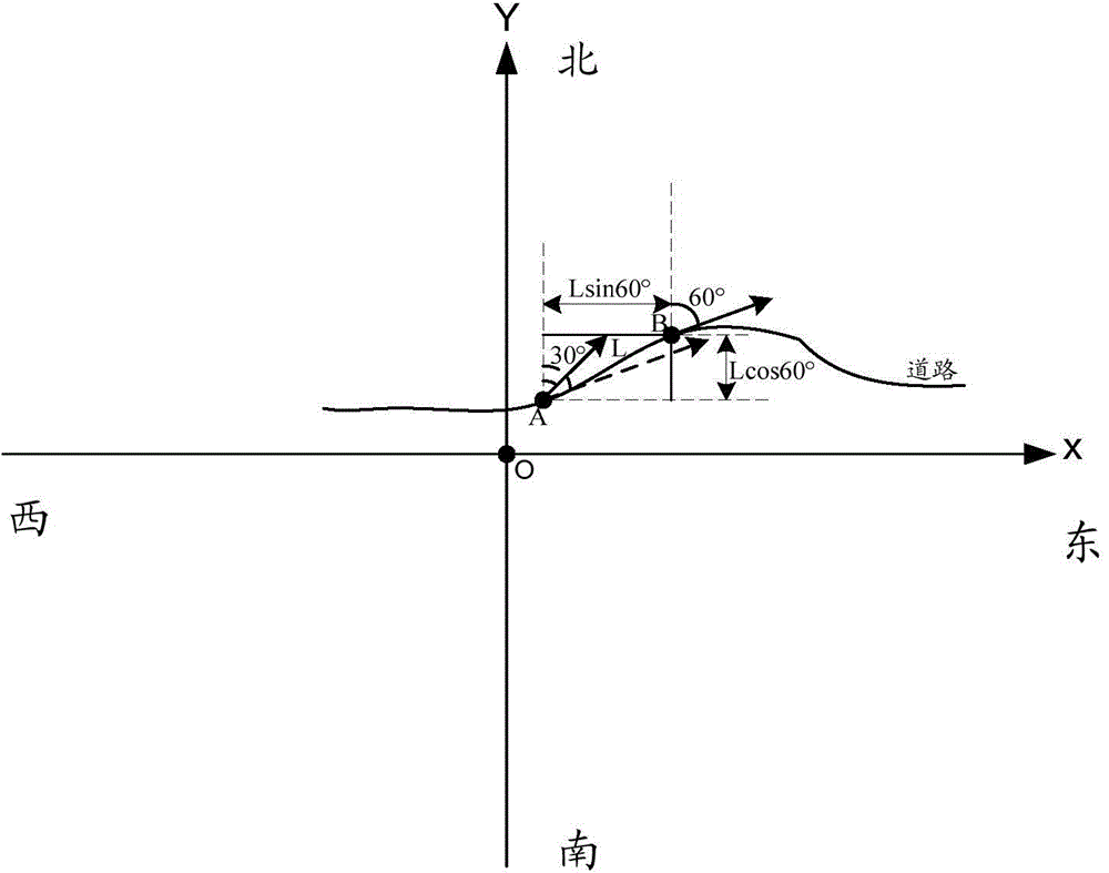
[0087] S202: Determine the angular increment of the vehicle within the time interval according to the angular velocity of the vehicle measured by the on-board gyroscope within the time interval, and compare the determined angular increment with the previous progress The driving direction of the vehicle sa...


PUM


Abstract

The invention relates to the technical field of electronic navigation, in particular to a navigation and positioning method and device which are used for solving the problems that the positioning accuracy is low and even positioning failure occurs caused by the fact a GPS receiver of a vehicle in prior art can not normally receive a satellite signal. The navigation and positioning method provided the embodiment of the invention comprises the following steps: obtaining a current vehicle running speed detected by an OBD (on-board diagnostic) system; according to the obtained current vehicle running speed and the time interval of current time and former navigation and positioning time, determining a running distance of the vehicle in the time interval; obtaining the current vehicle running direction; according to the current vehicle running direction and the determined running distance, determining displacement information of the vehicle in the time interval; according to the displacement information, and the vehicle position information obtained by former positioning, determining current vehicle navigation position prediction information.

Description

technical field [0001] The invention relates to the technical field of electronic navigation, in particular to a navigation positioning method and device. Background technique [0002] Global Positioning System (Global Positioning System, GPS) is the second generation of satellite navigation system in the United States. Since the GPS navigation and positioning technology can provide users with high-precision, low-cost positioning and navigation information in real time on a global scale, the GPS system has become the most widely used and most practical global navigation and positioning in the world. system. [0003] At present, GPS navigation and positioning technology is also a navigation and positioning technology commonly used in vehicle driving. Since at any moment, any target on the earth equipped with a GPS receiver can know its latitude and longitude coordinates, running speed, etc. through the GPS positioning system, therefore, installing a vehicle-mounted GPS rece...

Claims


Application Information

Patent Timeline
IPC IPC(8): G01C21/34G01C21/36G01S19/49
Inventor 白耕王晋高
Owner 北京易行出行旅游有限公司
Why Eureka
Try Eureka