Autonomous landing visual positioning method and system for unmanned aerial vehicle

A visual positioning and autonomous landing technology, applied in the field of unmanned aerial vehicles, can solve problems such as difficulty in achieving cm-level landing accuracy, large vertical positioning accuracy error, and poor aircraft landing accuracy.

Active Publication Date: 2016-02-17
XIAN WIDE WORLD ZENITH AVIATION TECH
View PDF5 Cites 38 Cited by
  • Summary
  • Abstract
  • Description
  • Claims
  • Application Information

AI Technical Summary

Problems solved by technology

However, due to the development level of GPS and Beidou and other systems, the horizontal positioning accuracy error (X, Y direction) is about ±3m, and the vertical positioning accuracy error (Z direction) is even larger
lead to poor landing accuracy of the aircraft
It is difficult to achieve cm-level landing accuracy, which is impossible for many application scenarios that require high-precision autonomous landing, such as: automatic return to the voyage for charging, landing on a ship, etc.

Method used


Image

  • Autonomous landing visual positioning method and system for unmanned aerial vehicle
  • Autonomous landing visual positioning method and system for unmanned aerial vehicle
  • Autonomous landing visual positioning method and system for unmanned aerial vehicle

Examples


Embodiment Construction

[0026] The present invention will be described in detail below in conjunction with the accompanying drawings.

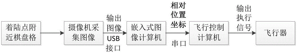
[0027] refer to Figure 1 to Figure 5 , in order to solve the problem of high-precision landing positioning of vertical take-off and landing aircraft, especially vertical take-off and landing unmanned aerial vehicles, the present invention provides an image recognition positioning method to enable the aircraft to achieve cm-level high-precision automatic landing. The technical method adopted in the present invention is: a kind of unmanned aerial vehicle autonomous landing visual positioning method, comprises the following steps:

[0028] 1) Use the GPS positioning system to determine the target azimuth range;

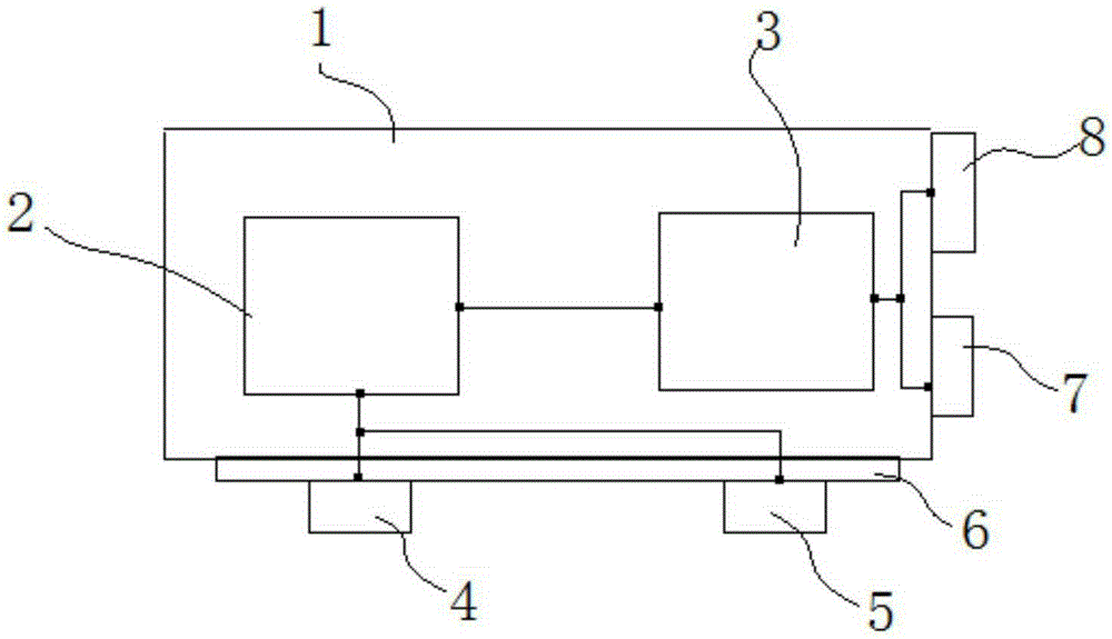
[0029] 2) After calibrating the camera parameters and pose, take pictures with the first camera 4. Step 1) Determine the mark pattern outside the target orientation range, and transfer the captured mark pattern to the embedded image computer 2 through the USB...


PUM


Abstract

The invention discloses an autonomous landing visual positioning system for an unmanned aerial vehicle. When the unmanned aerial vehicle is close to a landing point and enters an effective range, the relative position and attitude between the unmanned aerial vehicle and the landing point can be accurately estimated by virtue of visual computation and transmitted to a control mechanism of the unmanned aerial vehicle, so that the unmanned aerial vehicle is guided to accurately land to a designated place. The autonomous visual positioning system for the unmanned aerial vehicle, provided by the invention, comprises an unmanned aerial vehicle body, a GPS receiver and an inertia measurement device arranged on the unmanned aerial vehicle body, and an embedded image computer, wherein a photoelectric reconnaissance platform is arranged at the bottom of the unmanned aerial vehicle body; a first camera and a second camera are arranged on the photoelectric reconnaissance platform; the embedded image computer is respectively connected with the first camera and the second camera and is also connected with a flight control computer; and the flight control computer is respectively connected with the GPS receiver and the inertia measurement device.

Description

technical field [0001] The invention relates to the technical field of drones, in particular to a visual positioning method and system for autonomous landing of drones. Background technique [0002] The current hovering aircraft has the function of vertical take-off and landing, and its main navigation and positioning methods mostly rely on satellite navigation systems such as GPS or Beidou. However, due to the development level of systems such as GPS and Beidou, the horizontal positioning accuracy error (X, Y direction) is about ±3m, and the vertical positioning accuracy error (Z direction) is even larger. This leads to poor landing accuracy of the aircraft. It is difficult to achieve cm-level landing accuracy, and many application scenarios that require high-precision autonomous landing cannot be realized, such as; automatic return to the voyage for charging, landing on a ship, etc. Contents of the invention [0003] In order to solve the defects of the prior art, the ...

Claims


Application Information

Patent Timeline
Patent Type & Authority Applications(China)
IPC IPC(8): G06K9/00G06T7/00G01S19/13B64D47/08
CPCG01S19/13B64D47/08G06V20/10B64U70/00
Inventor 王辉
Owner XIAN WIDE WORLD ZENITH AVIATION TECH
Why Eureka
Try Eureka