
Unmanned aerial vehicle accurate landing method integrating H pattern recognition and AprilTag two-dimensional code recognition

A technology of drones and two-dimensional codes, applied in character and pattern recognition, computer parts, instruments, etc., can solve problems such as signal loss, landing at the wrong place, and error increase, so as to improve accuracy, reduce burden, Guaranteed high-precision results

Active Publication Date: 2020-04-10
SHANDONG UNIV
View PDF7 Cites 17 Cited by
  • Summary
  • Abstract
  • Description
  • Claims
  • Application Information

AI Technical Summary

Problems solved by technology

[0004] Before image recognition based on deep learning, the conventional landing method was to rely on GPS positioning to assist landing, while the civilian-level GPS positioning accuracy can reach about 10m, the error is relatively large, and the GPS signal is in areas with many obstacles, such as buildings. Dense objects or forests will cause increased errors or even signal loss, and may even be interfered by malicious satellite positioning signals and land in the wrong place; professional-grade high-precision GPS equipment is expensive and not economically practical
[0005] However, only using deep learning image recognition, there will be the problem of unmanned aerial vehicles being disturbed by the wind, AprilTags is a visual reference system, suitable for various tasks, including augmented reality, robot and camera calibration, AprilTags detection software calculation Precise 3D position, orientation and identification of tags relative to the camera

Method used


Image

  • Unmanned aerial vehicle accurate landing method integrating H pattern recognition and AprilTag two-dimensional code recognition
  • Unmanned aerial vehicle accurate landing method integrating H pattern recognition and AprilTag two-dimensional code recognition
  • Unmanned aerial vehicle accurate landing method integrating H pattern recognition and AprilTag two-dimensional code recognition

Examples


Embodiment 1

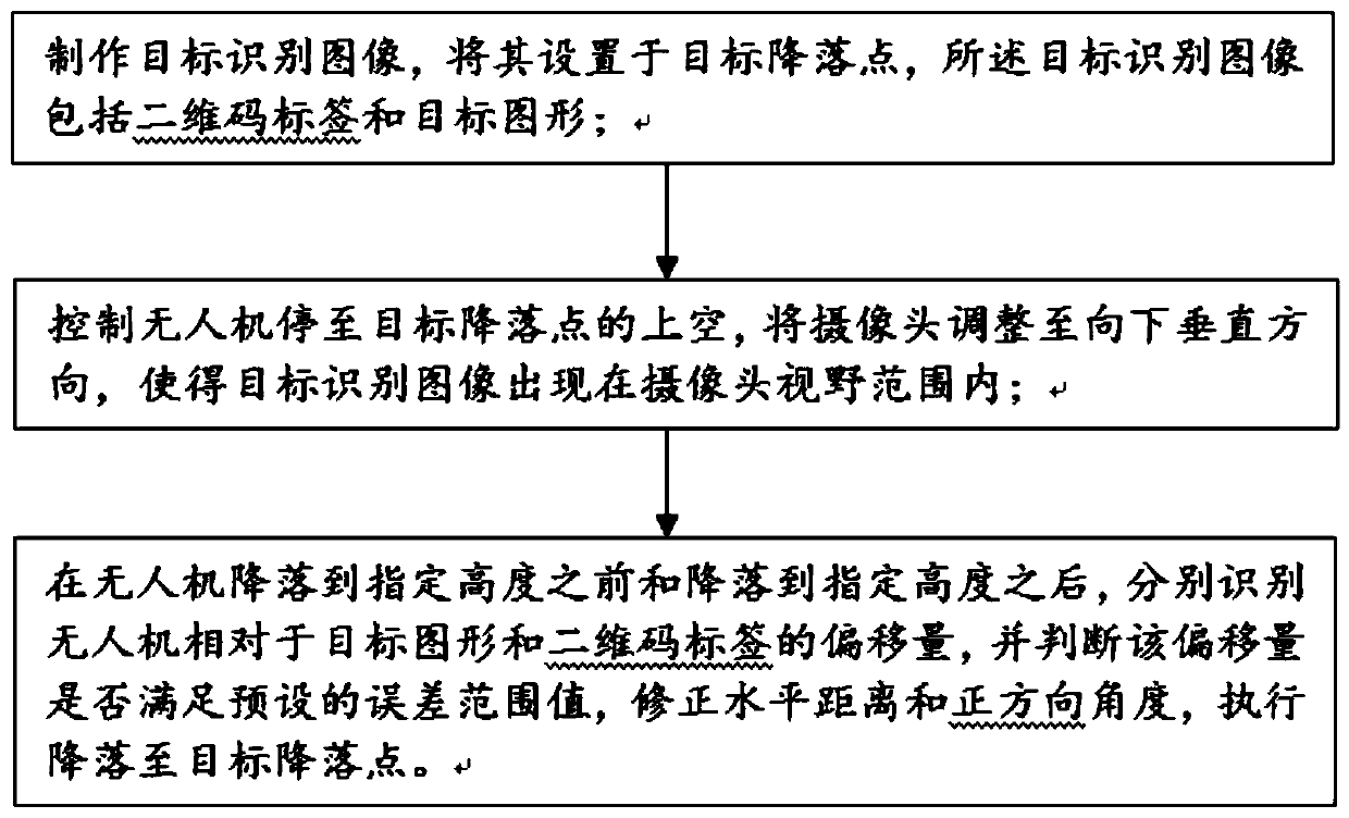
[0041] Such as figure 1 As shown, the present disclosure provides a method for precise landing of UAVs that integrates H pattern recognition and AprilTag two-dimensional code recognition, including:

[0042] Step 1: Make a target recognition image, and set it at the target landing point, that is, in the apron; the target recognition image includes a two-dimensional code label and a target graphic;

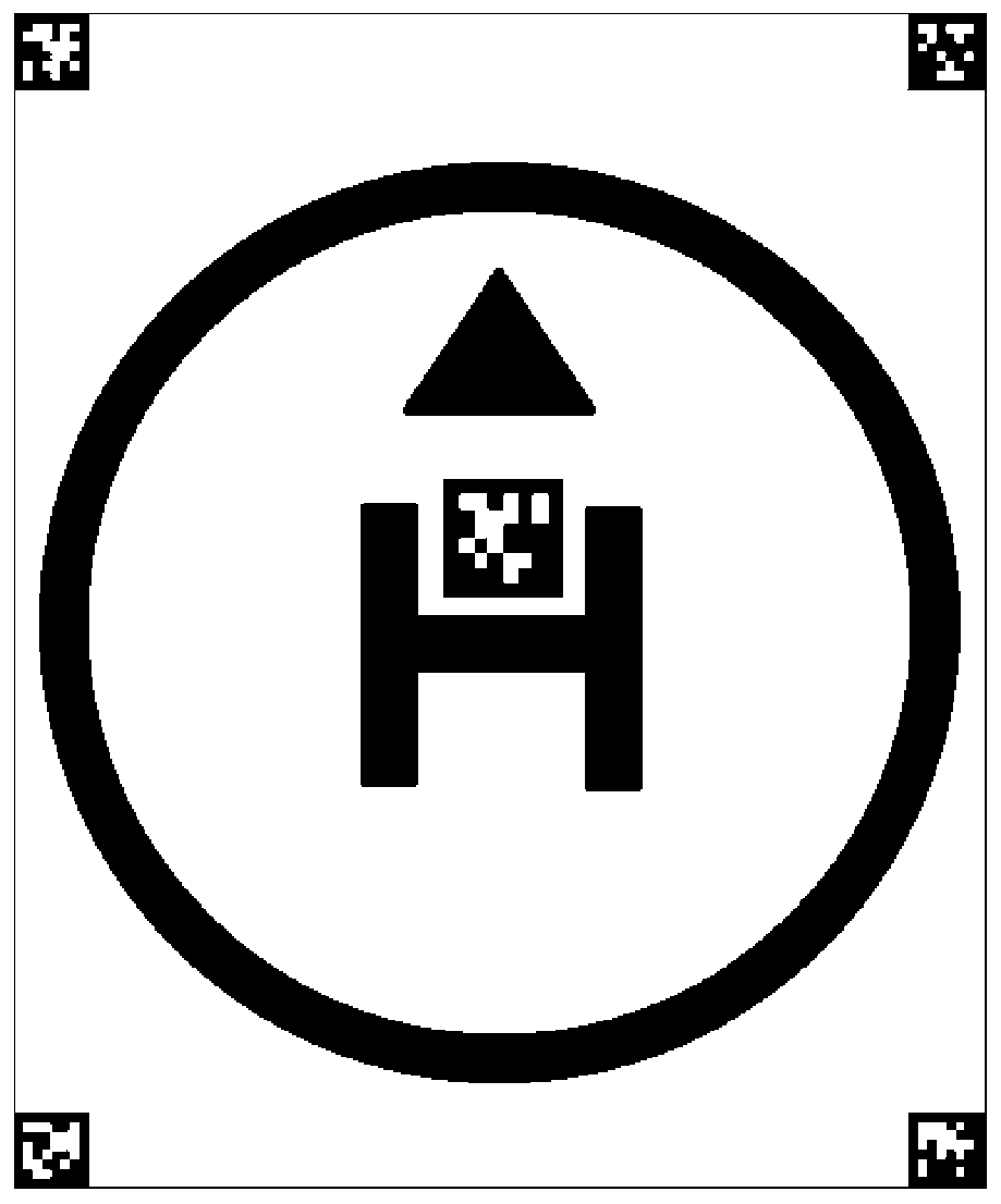
[0043] The target recognition image is composed of the outermost circle, triangle, "H" and five two-dimensional code labels. The pattern is black with a bright yellow background;

[0044] Among them, the "H" mark is located in the very center of the image, and the top of the "H" mark is a triangle. The side marked with the triangle corresponds to the front of the drone, and the other side corresponds to the rear of the drone. The side corresponds to the two sides of the landing legs of the drone; the color of the apron is not unique, try to choose a color with a strong contrast, ...

Embodiment 2

[0073] The present disclosure provides a UAV precision landing system that integrates H pattern recognition and AprilTag two-dimensional code recognition, including,

[0074] An image drawing module, which is used to make a target recognition image, and the target recognition image includes a two-dimensional code label and a target graphic;

[0075] A control module, which is used to control the UAV to stop over the target landing point, and adjust the camera to a downward vertical direction, so that the target recognition image appears within the camera field of view;

[0076] The identification and adjustment module is used to identify the offset of the drone relative to the target graphic and the two-dimensional code label before and after the drone lands at the specified height, and determine whether the offset is Satisfy the preset error range value, adjust the horizontal distance and positive direction angle, and perform landing to the target landing point.


PUM


Abstract

The invention discloses an unmanned aerial vehicle precise landing method integrating H pattern recognition and AprilTag two-dimensional code recognition. The method comprises the steps: making a target recognition image which comprises a two-dimensional code label and a target graph, and setting the target recognition image at a target landing point; controlling the unmanned aerial vehicle to stop above the target landing point, and adjusting the camera to a downward vertical direction to enable the target recognition image to appear in the view field range of the camera; and before and afterthe unmanned aerial vehicle lands to a specified height, respectively identifying the offset of the unmanned aerial vehicle relative to the target graph and the two-dimensional code label, judging whether the offset meets a preset error range value or not, adjusting the horizontal distance and the positive direction angle, and executing landing to a target landing point. Performance balance during image recognition is guaranteed, the influence of wind disturbance is avoided during landing, and high precision, stability and reliability of the whole landing process are guaranteed.

Description

technical field [0001] The present disclosure relates to the technical field of precise landing of drones, in particular to a method for precise landing of drones that integrates H pattern recognition and AprilTag two-dimensional code recognition. Background technique [0002] The statements in this section merely provide background information related to the present disclosure and do not necessarily constitute prior art. [0003] With the development and popularization of drone technology, the autonomous landing technology of drones is an important part of the automation of drones, and the precision landing technology is a technology that requires high precision in landing technology, so the corresponding The difficulty is even greater. [0004] Before image recognition based on deep learning, the conventional landing method was to rely on GPS positioning to assist landing, while the civilian-level GPS positioning accuracy can reach about 10m, the error is relatively large...

Claims


Application Information

Patent Timeline
Patent Type & Authority Applications(China)
IPC IPC(8): G06K7/14G06K9/00
CPCG06K7/1443G06V20/10
Inventor 李新董思远吴祥雨
Owner SHANDONG UNIV
Learn More