Method and device for determining road curvature in electronic map

A road curvature, electronic map technology, applied in geographic information database, structured data retrieval and other directions, can solve the problems of high collection cost, high cost, low efficiency, etc., and achieve the effect of improving versatility, reducing determination cost, and improving efficiency

Active Publication Date: 2019-02-26
北京易行出行旅游有限公司
View PDF6 Cites 0 Cited by
  • Summary
  • Abstract
  • Description
  • Claims
  • Application Information

AI Technical Summary

Problems solved by technology

[0004] Due to the existing technology to collect road curvature requires special instruments for on-site collection, there are problems of low efficiency and high cost
At the same time, due to the extremely high cost of collection, the field collection method can only collect a small number of road curvatures, that is to say, the existing road curvature collection methods cannot obtain most or all of the road curvatures, thus reducing the versatility of the existing road curvature collection methods

Method used


Image

  • Method and device for determining road curvature in electronic map
  • Method and device for determining road curvature in electronic map
  • Method and device for determining road curvature in electronic map

Examples


Embodiment Construction

[0025] In order to improve the versatility and efficiency of the method for determining the curvature of a road in an electronic map, the embodiments of the present invention provide a method and device for determining the curvature of a road in an electronic map.

[0026] The preferred embodiments of the present invention will be described below in conjunction with the accompanying drawings. It should be understood that the preferred embodiments described here are only used to illustrate and explain the present invention, and are not intended to limit the present invention, and in the absence of conflict, the present invention The embodiments and the features in the embodiments can be combined with each other.

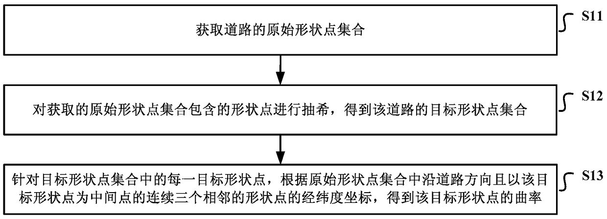
[0027] Such as figure 1 As shown, it is a schematic flowchart of the implementation of the method for determining the curvature of the road in the electronic map provided by the embodiment of the present invention, which may include the following steps:

[0028] S11....


PUM


Abstract

The invention discloses a determination method and apparatus for road curvature in an electronic map. The determination apparatus is used for improving the efficiency of the road curvature determination and the universality of the determination method for the road curvature. The determination method for the road curvature in the electronic map comprises: obtaining an original shape point set of a road; reducing shape points in the original shape point set to obtain a target shape point set of the road; and for each target shape point in the target shape point set, obtaining the curvature of the target shape point according to longitude and latitude coordinates of three continuous adjacent shape points which are in a road direction and take the target shape point as a middle point in the original shape point set.

Description

technical field [0001] The invention relates to the technical field of electronic map drawing, in particular to a method and device for determining the curvature of a road in an electronic map. Background technique [0002] Advanced Driver Assistance (ADAS, Advance Driver Assistant System) is a sensor-based system and technology that uses a variety of sensors installed in the car (these sensors can detect light, heat, pressure or other variables used to monitor the state of the car) Collect the environmental data inside and outside the car at the first time, and combine the pre-stored road attribute data (such as road slope, curvature and average speed information, etc.) to carry out technical processing such as identification, detection and tracking of static and dynamic objects, so that Let the driver be aware of possible dangers in the fastest time. Because it can significantly reduce the number of traffic accidents, it becomes the development direction of future car nav...

Claims


Application Information

Patent Timeline
Patent Type & Authority Patents(China)
IPC IPC(8): G06F16/29
Inventor 贾双成叶旻
Owner 北京易行出行旅游有限公司
Why Eureka
Try Eureka