Rapid thematic map drawing technology

A mapping technology and thematic map technology, applied in special data processing applications, instruments, electrical digital data processing, etc., can solve the lack of unified management of basic geographic information and disaster information, lack of disaster information display tools, symbol plotting tools, products Difficult results and other problems, to achieve the effect of improving the drawing speed

Inactive Publication Date: 2016-05-25
BEIJING GEOWAY INFORMATION TECH
View PDF5 Cites 10 Cited by
  • Summary
  • Abstract
  • Description
  • Claims
  • Application Information

AI Technical Summary

Problems solved by technology

When making a new issue of disaster emergency mapping products, the map matching process often takes a lot of time, and it is difficult to reuse the results of previous products as templates, requiring a lot of modification work on the original basis
[0006] 2. The basic geographic information and disaster information that cartography products rely on lack of unified management, and the efficiency of data selection and organization is low
[0008] 4. There is a lack of disaster information display tools and symbol plotting tools for disaster business characteristics, which cannot meet the needs of disaster emergency mapping

Method used


Image

  • Rapid thematic map drawing technology
  • Rapid thematic map drawing technology
  • Rapid thematic map drawing technology

Examples


Embodiment

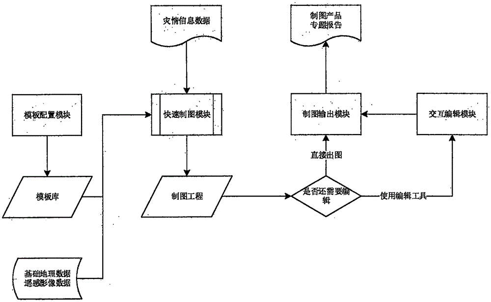
[0025] Using the technical scheme described in the present invention, the drawing process of natural disaster emergency products ( figure 1 )Specific steps are as follows:

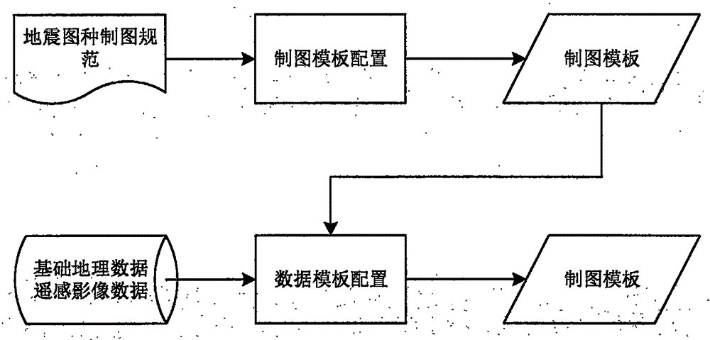
[0026] Step 1: Build a template library and prepare basic data for mapping.

[0027] figure 2 It shows that building a template library is the template configuration process. According to the emergency mapping business of natural disasters, templates suitable for different disaster map types are pre-customized, and each map type is subdivided into several sub-templates according to the mapping scope and finishing layout. The content that needs to be configured in the cartographic template includes but is not limited to layer symbolic rendering, labeling scheme and label avoidance rules, cartographic generalization, page decoration, etc. Based on the construction of the template library, it can meet the needs of scale, symbolic expression, and cartographic comprehensive self-adaptation for different cart...


PUM


Abstract

The present invention relates to rapid geographical spatial information map-drawing technologies, and in particular, to a rapid thematic map drawing technology. The technology mainly comprises the following modules: a template configuration module, a configuration map-drawing module and a data template, which are used for template library construction and data organization and data selection; a rapid map-drawing module, which are used for one-click production of an earthquake emergency thematic product; an interactive editing module, which is used for performing drawing refined editing by using a drawing interaction tool on the basis of one-click drawing; and a drawing output module, which is used for exporting a drawing result in multiple formats and automatically generating a product thematic report.

Description

technical field [0001] The invention relates to a rapid mapping technology of geographic space information, in particular to a technology suitable for emergency response to natural disasters, oriented to different administrative levels such as countries, provinces, cities, counties, towns, villages, etc., buildings, roads, farmland and other different objects, self-adaptive Different scales, one-key rapid mapping technology for data self-organization detection. Background technique [0002] After a natural disaster occurs, it is necessary to provide disaster emergency thematic mapping products in a timely manner based on basic geographic data and remote sensing data, combined with the disaster-causing factors, disaster-affected bodies, and disaster data of natural disasters, so as to provide intuitive information for disaster emergency response, command, rescue, and assessment decisions. , Efficient visual service support. [0003] However, most of the current disaster emer...

Claims


Application Information

Patent Timeline
IPC IPC(8): G06F17/30
CPCG06F16/29
Inventor 王卫京李彦孙银良
Owner BEIJING GEOWAY INFORMATION TECH
Why Eureka
Try Eureka