Farmland tenure publicity map automatically generating method

A technology for automatic generation and agricultural land rights, applied in the field of basic geographic information, can solve the problems such as the inability to guarantee the improvement of work efficiency, the inability to realize automation and intelligence in the production process of the public map of agricultural land ownership, large human and material resources, etc. Meet the effect of integrated management

Active Publication Date: 2016-05-25
江苏金沙地理信息股份有限公司
View PDF3 Cites 5 Cited by
  • Summary
  • Abstract
  • Description
  • Claims
  • Application Information

AI Technical Summary

Problems solved by technology

For the massive contracted land data in the land right confirmation work, if the existing mapping method is used to make the farmland ownership publicity map, it will require a lot of manpower and material resources, and the improvement of work efficiency and mapping results cannot be guaranteed. accurate
Therefore, there are many inconveniences and error-prone aspects in the production of agricultural land ownership publicity maps, especially in the acquisition of group unit administrative division data, layer framing and publicity information statistics and summarization
The production process of farmland ownership publicity maps cannot be automated and intelligent, which will bring great inconvenience to the management and analysis of land contractual management rights in the future

Method used


Image

  • Farmland tenure publicity map automatically generating method
  • Farmland tenure publicity map automatically generating method
  • Farmland tenure publicity map automatically generating method

Examples


Embodiment 1

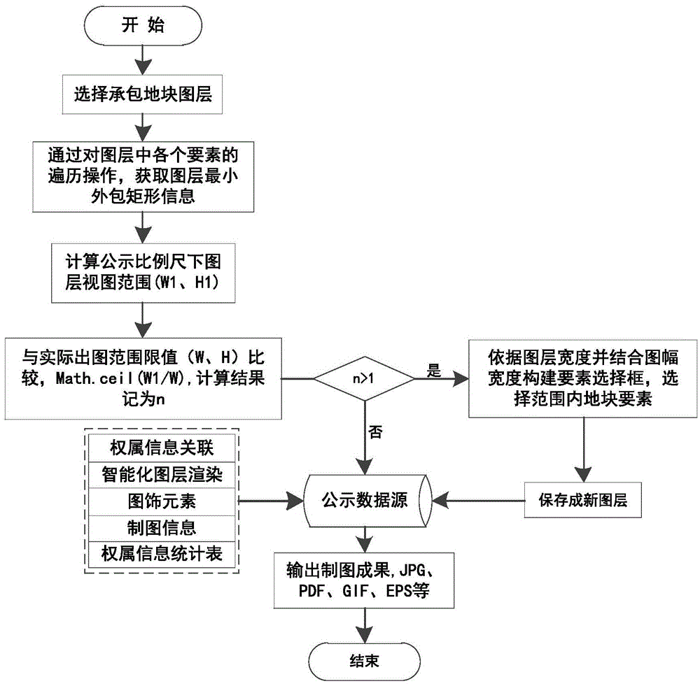
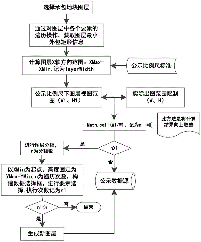
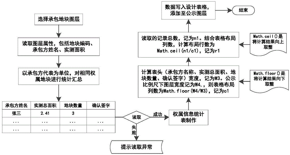
[0040] The specific implementation of this embodiment is a method for automatically generating a farmland ownership publicity map, and the specific flow chart is as follows figure 1 shown.

[0041] Step (1) Import the map data including the spatial position, geometric shape and labeling information of the contracted plots, select the contracted plot layer, and obtain the minimum enclosing rectangle information by traversing the elements in the layer, including XMax , the values ​​of XMin, YMax, and YMin, where XMax is the maximum value of the minimum enclosing rectangle on the X axis, XMin is the minimum value of the minimum enclosing rectangle on the X axis, and YMax is the minimum value of the minimum enclosing rectangle on the Y axis is the maximum value of , and YMin is the minimum value of the minimum enclosing rectangle in the Y-axis range. Calculate the range of the minimum enclosing rectangle obtained in the X and Y axes, respectively: XMax-XMin, YMax-YMin.

[0042] ...


PUM


Abstract

The present invention discloses a farmland tenure publicity map automatically generating method, and realizes automated production of a contracted land tenure publicity map in the work for rural land right. At present, most of professional softwares for publicity map production require to take a corresponding administrative map layer as a range control map layer for an mapmaking operation. However, in practice, a contracted land tenure publicity range takes a group as a unit, most of administrative division data in most areas is accurate to a village boundary, and existing mapmaking software does not yet well solve a problem that automatic mapmaking is difficult to be realized under the circumstances of lacking for the range control map layer. In addition, due to limitation of a mapmaking printing device, an actual mapmaking range of the publicity map also has limitation. When producing the publicity map in a large scale in most times, framing processing on the map layer is required to be carried out; and the existing software requires a large amount of manual operations to implement layer framing with a low automation degree. For the two shortcomings, the method disclosed by the present invention combines a computer technology with a geographic information technology, so that automation and intelligence of a farmland tenure publicity map production process are realized, production efficiency and accuracy are improved, and a large quantity of time and labor costs are saved.

Description

technical field [0001] The invention relates to the field of basic geographic information, in particular to an efficient method for automatically generating a publicity map of farmland ownership. Background technique [0002] With the continuous advancement of the confirmation of land rights in rural areas, various issues of land ownership left over from history have become increasingly prominent. Rural land ownership, use rights and other rights are chaotic and have not been clearly defined and effectively guaranteed. The work of confirming rural land rights aims to find out the status of land, clarify land ownership, and promote the standardization of rural land management. In this process, it is the top priority to solve the problems of unreliable plots, unclear four-points, and inaccurate areas of rural land. On this basis, making farmland ownership publicity maps for farmers is an important implementation link for the next step. The publicity map of farmland ownershi...

Claims


Application Information

Patent Timeline
Patent Type & Authority Applications(China)
IPC IPC(8): G06F17/30G06Q50/26
CPCG06F16/29G06Q50/26
Inventor 王永志康念坤刘鹏彧杨路生
Owner 江苏金沙地理信息股份有限公司
Why Eureka
Try Eureka