Real-time and efficient drainage basin flood routing visual simulation method

A technology of basin flood evolution and simulation method, applied in the field of flood evolution visualization simulation, can solve the problems of false submerged area, large amount of calculation, lack of physical mechanism, etc., and achieve the effect of improving disaster reduction ability

Inactive Publication Date: 2016-06-01
CHINA INST OF WATER RESOURCES & HYDROPOWER RES
View PDF4 Cites 38 Cited by
  • Summary
  • Abstract
  • Description
  • Claims
  • Application Information

AI Technical Summary

Problems solved by technology

Most GIS software uses manual intervention to deal with active inundation, but the scalability and adaptability are not strong; in recent years, the more representative automatic processing methods for active inundation problems are the seed spreading method and the method of throwing stones.
Although these algorithms can identify flood submerged areas, they still have the following deficiencies: ① It is necessary to continuously and repeatedly detect submerged and connected areas. Rendering is inefficient
②The smallest unit used for calculation and display is a regular or arbitrary polygonal grid. The coarser grid unit not only makes the expression ac

Method used


Image

  • Real-time and efficient drainage basin flood routing visual simulation method
  • Real-time and efficient drainage basin flood routing visual simulation method
  • Real-time and efficient drainage basin flood routing visual simulation method

Examples


Embodiment 1

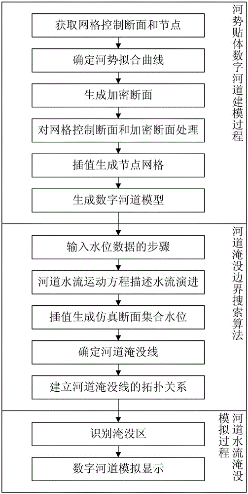
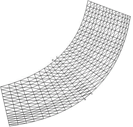
[0033] This embodiment is a real-time and efficient visual simulation method for river basin flood evolution. The process is as follows figure 1 shown. The method described in this embodiment includes three processes: a body-fitting digital river course modeling process, a search algorithm for the river course submerged boundary, and a river course flow submersion simulation process. This embodiment can use any object-oriented computer language to write computer programs, and the programs can run across computer platforms. If the computer supports a parallel processing architecture, the subsequent steps can be processed in parallel to increase the processing speed and make the display smoother.

[0034] The basic ideas of this embodiment are as follows: first, the concept of river regime is combined with the idea of ​​body-fitted grid generation to establish a body-fitted digital river channel model of river regime; Search the submerged line segments of adjacent sections, sp...

Embodiment 2

[0135]This embodiment is an improvement of Embodiment 1, and is about the simulation of flooding of tree-like river network. Extend the single channel or river section to the step-by-step confluence of the tree-like river network for visual simulation of flood evolution. The tree-like river network usually exists in alpine and hilly areas. For the calculation of the flood evolution of the tree-like river network, the calculation is usually carried out step by step, and the solution is solved using a three-level solution method. Based on this, the water levels at all calculation sections of the tree-like river network can be calculated, and then based on the water levels of the calculation sections, interpolation generates adjacent Calculate the water level of the dense section between the sections, and according to the river boundary search method in Embodiment 1, the submerged line of a single river section forming a tree-shaped river network can be searched and the flood subm...

Embodiment 3

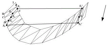
[0147] This embodiment is an improvement of the first embodiment, and it is a visual simulation of the flooding process of the annular river network in the first embodiment. In the ring river network, there is no clear confluence relationship between the river channels. Under different calculation boundaries, the water flow may have reciprocating motion, and there is no obvious relationship between stem and branch. Therefore, in the calculation, the river channel at the node will be merged They are regarded as separate calculation river sections, and the calculation assumes that the water levels at the inflow sections of the separate calculation river sections are equal. Then its special feature is the search of the river boundary at the river junction. by Figure 8 Take an example to illustrate the visual simulation of flood inundation of ring river network.

[0148] The steps of visual simulation of flood inundation of annular river network are as follows:

[0149] (1) Th...


PUM


Abstract

The invention relates to a real-time and efficient drainage basin flood routing visual simulation method. The method comprises the steps that grid control sections and nodes are acquired; a river regime fitted curve is determined; an encrypted section is generated; the grid control sections and the encrypted section are processed; a node grid is generated through interpolation; a digital riverway model is generated; section water level data is acquired; a section water level matched with the digital riverway terrain grid is generated through interpolation; submerging lines of a single riverway or tree-shaped river network or annular river network are determined; the topological relation between the riverway submerging lines is built; an inundated area is determined; riverway water flow routing visual display is carried out. According to the method, the flood routing condition of a drainage basin can be displayed efficiently in real time, a continuously changing flood inundation layer can be created, the local or full-area inundated area is stereoscopically observed according to the elevation of the water surface, the superficial area and water storage of flood water surface inundation at a certain elevation can be calculated in real time for a local flood inundation region, the method directly serves drainage basin flood control and disaster reduction, and important theoretical and practical significance is achieved on disaster reduction capacity improving.

Description

technical field [0001] The invention belongs to the field of visual simulation of flood evolution, and relates to a real-time and efficient visual simulation method for river basin flood evolution, which is a visual simulation method for river basin flood evolution based on numerical simulation and measured data, and a river basin flood evolution based on parallel processing architecture Visual simulation methods. Background technique [0002] The simulation of watershed flood evolution is driven by observation data and calculation of hydrological and hydrodynamic models. In the computer-generated virtual watershed environment, the three-dimensional and intuitive dynamic simulation simulates the spatiotemporal evolution process and inundation status of floods in real river channels. Due to the dynamic changes of incoming water and sediment conditions, and the interaction between water flow and basin topography, there are uncertainties in the submerged area of ​​the river cha...

Claims


Application Information

Patent Timeline
IPC IPC(8): G06F17/50
CPCG06F30/20Y02A10/40Y02A20/152
Inventor 冶运涛梁犁丽尚毅梓赵红莉韩素华杜军凯仇亚琴卢琼
Owner CHINA INST OF WATER RESOURCES & HYDROPOWER RES
Why Eureka
Try Eureka