Method for measuring and calculating construction area of marine ranching in island reef waters featuring complex landform

A technology for marine ranching and complex terrain, applied in the field of measurement and calculation, to achieve the effect of overcoming the complicated process

Inactive Publication Date: 2016-07-20
SHANGHAI OCEAN UNIV
View PDF5 Cites 0 Cited by
  • Summary
  • Abstract
  • Description
  • Claims
  • Application Information

AI Technical Summary

Problems solved by technology

However, there is no solution in the existing technology that can achieve accurate statistics. Therefore, a new technical solution needs to be born

Method used


Image

  • Method for measuring and calculating construction area of marine ranching in island reef waters featuring complex landform
  • Method for measuring and calculating construction area of marine ranching in island reef waters featuring complex landform
  • Method for measuring and calculating construction area of marine ranching in island reef waters featuring complex landform

Examples


Embodiment 1

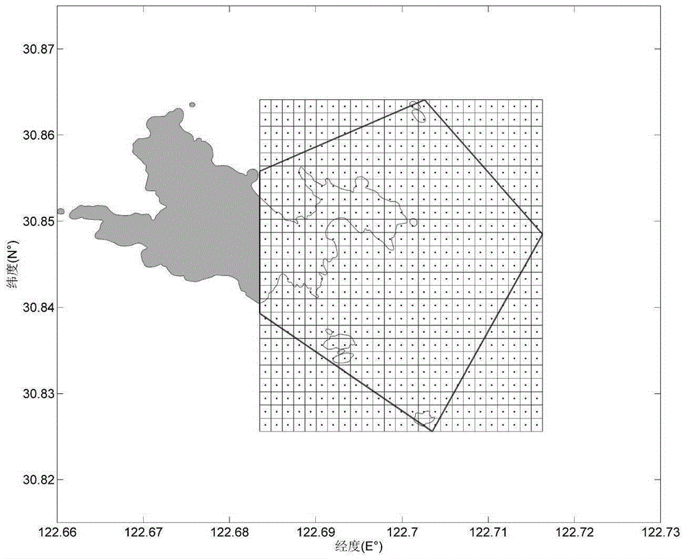
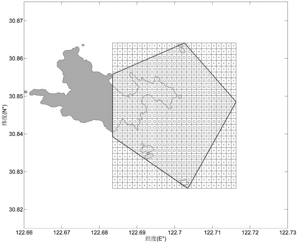
[0039] Calculation of the actual sea area of ​​the marine ranch in the island and reef sea area and the sea area of ​​different water depths

[0040]1. Taking the marine ranching planning area of ​​a certain island and reef sea area as an example, calculate the actual sea area of ​​the marine ranch and the area of ​​the sea area at different water depths;

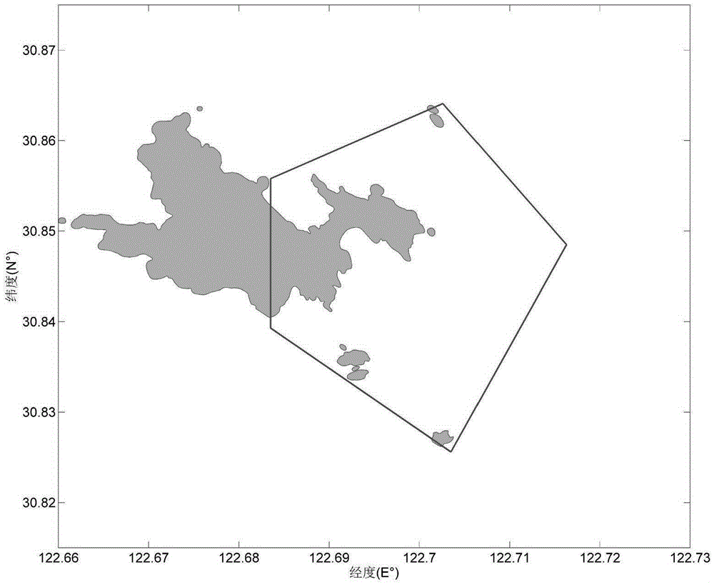
[0041] 2. Obtain the geographic coordinates of the coastlines of the islands and reefs contained in the sea area of ​​​​the marine ranch. Several points on the coastlines of each island and reef can form any closed polygon. There can be a total of i closed polygons for i islands and reefs, which are recorded as A 1 -A i ;

[0042] 3. Given the geographic coordinate range of the marine ranching area, form an arbitrary closed polygon, denoted as B, which has overlapping parts with the closed polygon formed by the coastline of islands and reefs ( figure 1 );

[0043] 4. According to the geographic coordinates of the marine ...


PUM


Abstract

The invention discloses a method for measuring and calculating a construction area of a marine ranching in island reef waters featuring complex terrain. The method comprises the following steps: performing uniform grid division on approximate rectangular waters defined by the minimum and the maximum coordinates in east-west direction and north-south direction of planned waters of the marine ranching, determining and calculating the number of control points that fall within an actual planning region featuring arbitrary polygon shape, and deducting the number of control points that fall within land such as island reefs, multiplying the proportion of the number of control points within the waters of the planning region of the total number of control points with the area of the aforementioned rectangular waters so as to obtain the product which is the total area of the planning region of the marine ranching. According to the invention, when the method is used for measuring and calculating the area of the marine ranching, in accordance with water depth data interpolation, the water depth value of each control point is calculated, so that the area of waters having different water depth sections can be calculated, which provides accurate sea area data for marine ranching planning regions when coast marine entities report a marine ranching planning region, plans a marine ranching construction plan, estimates a marine ranching engineering amount that is constructable, and conducts marine environment assessments and the like.

Description

technical field [0001] The invention relates to a method for measurement and calculation, in particular to a method for measurement and calculation of the construction area of ​​a marine ranch area in a sea area with complex terrain islands and reefs. Background technique [0002] Marine ranching is a "release system based on marine ecosystem management" that combines various fishery production factors organically through artificial fish reefs and other biological habitat improvement technologies, fishery resource proliferation technologies such as larvae release, and fish behavior control technologies such as audio-feeding baiting and domestication. The controllable mechanism of "breeding-recapture" maximizes the use of sea area productivity and sea area space, so that the comprehensive output of fishery can obtain sustainable benefits of fishery production and management mode. Many coastal countries around the world use marine ranching as the main means of their fishery mo...

Claims


Application Information

Patent Timeline
IPC IPC(8): G06T7/60
CPCG06T2207/20021
Inventor 林军邓明星闫庆章守宇
Owner SHANGHAI OCEAN UNIV
Why Eureka
Try Eureka