Method for predicating road jam through mobile phone information

A mobile phone information and road technology, which is used in location-based services, traffic control systems for road vehicles, wireless communications, etc. The effect of running speed

Inactive Publication Date: 2016-07-20
DALIAN UNIV OF TECH
View PDF7 Cites 13 Cited by
  • Summary
  • Abstract
  • Description
  • Claims
  • Application Information

AI Technical Summary

Problems solved by technology

Therefore, researchers must obtain enough vehicle GPS information to calculate accurately. Usually, in the first-tier cities, there are many vehicles equipped with GPS, but in other cities, the number of vehicles with GPS installed or turned on is relatively small, and the GPS function The consumption is high, and the calculated results are not very accurate in many cases, so the researchers' research in this field has become difficult
Some researchers obtain more data in real time by installing GPS on taxis. However, due to the single and incomplete data collection object, the difficulty of traffic data collection has brought great difficulty to the research and development of researchers.

Method used


Image

  • Method for predicating road jam through mobile phone information
  • Method for predicating road jam through mobile phone information
  • Method for predicating road jam through mobile phone information

Examples


Embodiment Construction

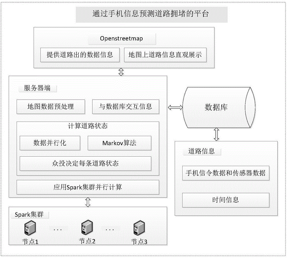
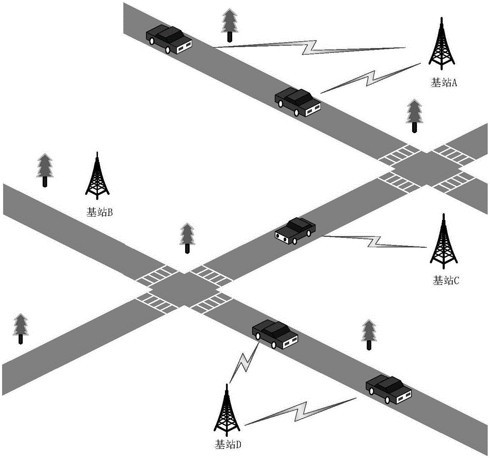
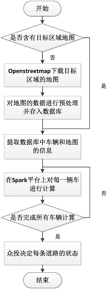
[0067] Such as figure 1 As shown, a method for predicting road congestion through mobile phone signaling, the method is composed of Openstreetmap, server, database, Spark cluster and road information; the server is responsible for managing the Spark cluster, preprocessing the map information of Openstreetmap, Data interaction with the database; OpenStreetmap is an online map collaboration plan, responsible for providing system map data, which is the basis of the entire system data; the server-side Markov algorithm is implemented by the Java language, and at the same time, the Spark cluster is used for parallel computing to ensure the speed of the algorithm and The real-time nature of the data; the Markov algorithm uses the idea of ​​dynamic programming to calculate the general path of travel from some inaccurate points, and calculates the speed from the length and time of the path, and matches the corresponding road conditions through the speed. The congestion situation of eac...


PUM


Abstract

The invention belongs to the field of computer application technology, and relates to a method for predicting road jam through mobile phone information. According to the method, a road jam condition is calculated based on a Markov algorithm through acquiring a large amount of mobile phone positioning information. The method realizes accurate analysis on the road jam condition through simply and quickly generating a map database, storing road data into the database, introducing the positioning information into the database, calculating the data in the database and obtaining the jam condition. The method has advantages of low cost, large coverage area and high accuracy.

Description

technical field [0001] The invention belongs to the technical field of computer applications and relates to a method for predicting road congestion through mobile phone information. Background technique [0002] With the explosive growth of the number of cars, traffic congestion has become an important problem in urban traffic. At present, more and more researchers are investing in this field. However, the technologies studied at this stage are basically based on static sensors, and some technologies are researched by means of vehicle-mounted GPS. These methods have great limitations. The installation of detectors and cameras on the road is a static sensor method. When the vehicle passes, the continuous sensors on the road will record the time of the vehicle passing, thereby calculating the speed of the vehicle. The results obtained by the sensor method are usually accurate, but the cost of deployment, operation, maintenance and replacement of static sensors is relatively e...

Claims


Application Information

Patent Timeline
Patent Type & Authority Applications(China)
IPC IPC(8): G08G1/01H04W4/02H04W4/04
CPCG08G1/012H04W4/026H04W4/027H04W4/04
Inventor 申彦明张通
Owner DALIAN UNIV OF TECH
Why Eureka
Try Eureka